M4.6 earthquake 69 km SE of Unalaska, Alaska
A magnitude 4.6 earthquake struck 69 km SE of Unalaska, Alaska on Sun, Aug 7, 2022, 6:01 AM AKDT (14:01 UTC), 43 km (27 mi) below the surface.
Map
Where this earthquake was located, with the others nearby. Select one for its page.
The earthquake
- Magnitude
- 4.6 (mb), light
- Local time
- UTC
- 2022-08-07 14:01:46 UTC
- Depth
- 43.1 km (26.8 mi), shallow
- Epicenter
- 53.484° N, 165.707° W
- Region
- Alaska
- Felt reports
- 2
- Strongest shaking
- II, weak shaking
- Tsunami flag
- No
- Status
- Reviewed by a seismologist
Shaking
The USGS ShakeMap: shaking estimated from seismic stations and the quake’s size, on the Modified Mercalli intensity scale.
- Strongest estimated
- II, weak shaking
- Peak ground acceleration
- 0.2% of gravity
- Peak ground velocity
- -2.8 cm/s
- Map
- Automatic

Did you feel it?
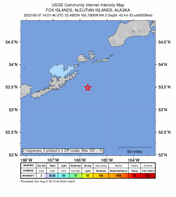
2 people reported to the USGS what they felt; the strongest reported shaking was III, weak shaking.
How well it is located
Reviewed by a seismologist.
- Location uncertainty
- About 4.6 km horizontally, 6.0 km in depth
- Magnitude uncertainty
- ±0.05
- Depth from
- From location
- Station coverage gap
- 163°
- Stations used
- 116
Nearest places
Distance and direction from each place to the epicenter, with its forecast.
Nearby
Within 100 km, magnitude 1.6 and up: 137 in the 60 days after this one and 68 in the 30 days before it.
After
- 1.670 km SE of Unalaska, Alaska · 1514 days ago · 21 km deep · 0 km away
- 1.987 km S of Unalaska, Alaska · 1514 days ago · 19 km deep · 82 km away
- 1.680 km ESE of Akutan, Alaska · 1513 days ago · 52 km deep · 94 km away
- 3.885 km S of Unalaska, Alaska · 1513 days ago · 35 km deep · 78 km away
- 1.778 km S of Unalaska, Alaska · 1512 days ago · 20 km deep · 75 km away
- 2.554 km SSE of Unalaska, Alaska · 1510 days ago · 43 km deep · 26 km away
- 2.080 km SE of Akutan, Alaska · 1510 days ago · 49 km deep · 58 km away
- 1.985 km SE of Unalaska, Alaska · 1509 days ago · 36 km deep · 22 km away
- 2.688 km SE of Akutan, Alaska · 1509 days ago · 35 km deep · 61 km away
- 1.880 km SE of Unalaska, Alaska · 1509 days ago · 26 km deep · 19 km away
- 1.674 km S of Unalaska, Alaska · 1509 days ago · 25 km deep · 71 km away
- 1.681 km SE of Akutan, Alaska · 1508 days ago · 55 km deep · 56 km away
- 1.853 km SE of Akutan, Alaska · 1508 days ago · 50 km deep · 40 km away
- 1.659 km SE of Akutan, Alaska · 1507 days ago · 45 km deep · 43 km away
- 1.715 km SE of Akutan, Alaska · 1507 days ago · 74 km deep · 63 km away
- 2.7Fox Islands, Aleutian Islands, Alaska · 1507 days ago · 76 km deep · 49 km away
- 1.675 km SSE of Unalaska, Alaska · 1506 days ago · 36 km deep · 31 km away
- 1.778 km SSE of Unalaska, Alaska · 1506 days ago · 21 km deep · 31 km away
- 1.785 km SSW of Unalaska, Alaska · 1506 days ago · 34 km deep · 92 km away
- 4.195 km SSW of Unalaska, Alaska · 1506 days ago · 35 km deep · 94 km away
- 1.984 km SSW of Unalaska, Alaska · 1506 days ago · 40 km deep · 91 km away
- 3.577 km SSW of Unalaska, Alaska · 1506 days ago · 35 km deep · 81 km away
- 3.080 km S of Unalaska, Alaska · 1506 days ago · 32 km deep · 79 km away
- 2.883 km SSW of Unalaska, Alaska · 1506 days ago · 27 km deep · 81 km away
- 3.186 km S of Unalaska, Alaska · 1506 days ago · 35 km deep · 81 km away
- 3.084 km S of Unalaska, Alaska · 1506 days ago · 26 km deep · 81 km away
- 3.087 km S of Unalaska, Alaska · 1506 days ago · 29 km deep · 80 km away
- 1.978 km SSE of Akutan, Alaska · 1505 days ago · 44 km deep · 33 km away
- 1.688 km SSW of Unalaska, Alaska · 1505 days ago · 26 km deep · 92 km away
- 1.924 km SSE of Unalaska, Alaska · 1505 days ago · 72 km deep · 50 km away
- 1.888 km SSW of Unalaska, Alaska · 1504 days ago · 37 km deep · 93 km away
- 3.386 km SSW of Unalaska, Alaska · 1504 days ago · 35 km deep · 84 km away
- 1.6Fox Islands, Aleutian Islands, Alaska · 1504 days ago · 21 km deep · 84 km away
- 2.857 km SSW of Unalaska, Alaska · 1504 days ago · 96 km deep · 73 km away
- 1.682 km SSW of Unalaska, Alaska · 1504 days ago · 26 km deep · 81 km away
- 1.732 km SE of Unalaska, Alaska · 1502 days ago · 67 km deep · 37 km away
- 1.895 km SE of Akutan, Alaska · 1502 days ago · 26 km deep · 67 km away
- 1.776 km SE of Akutan, Alaska · 1502 days ago · 53 km deep · 62 km away
- 1.953 km ESE of Unalaska, Alaska · 1501 days ago · 33 km deep · 19 km away
- 1.979 km SE of Akutan, Alaska · 1501 days ago · 55 km deep · 63 km away
- 1.675 km S of Akutan, Alaska · 1500 days ago · 44 km deep · 7 km away
- 1.783 km SSW of Unalaska, Alaska · 1499 days ago · 21 km deep · 90 km away
- 1.974 km SSE of Akutan, Alaska · 1499 days ago · 40 km deep · 24 km away
- 1.993 km SE of Akutan, Alaska · 1499 days ago · 18 km deep · 50 km away
- 3.5126 km SE of Akutan, Alaska · 1497 days ago · 35 km deep · 78 km away
- 2.870 km SE of Akutan, Alaska · 1493 days ago · 35 km deep · 62 km away
- 3.1Fox Islands, Aleutian Islands, Alaska · 1493 days ago · 13 km deep · 74 km away
- 2.68 km WSW of Unalaska, Alaska · 1493 days ago · 12 km deep · 73 km away
- 1.6Fox Islands, Aleutian Islands, Alaska · 1493 days ago · 11 km deep · 70 km away
- 2.77 km WSW of Unalaska, Alaska · 1493 days ago · 13 km deep · 74 km away
- 1.677 km SE of Akutan, Alaska · 1491 days ago · 26 km deep · 45 km away
- 2.077 km SSE of Akutan, Alaska · 1489 days ago · 28 km deep · 29 km away
- 1.660 km SSE of Akutan, Alaska · 1489 days ago · 50 km deep · 27 km away
- 3.880 km SSW of Unalaska, Alaska · 1488 days ago · 36 km deep · 80 km away
- 2.885 km S of Unalaska, Alaska · 1488 days ago · 31 km deep · 82 km away
- 3.387 km SE of Akutan, Alaska · 1488 days ago · 35 km deep · 46 km away
- 3.573 km SE of Akutan, Alaska · 1488 days ago · 44 km deep · 42 km away
- 1.756 km SW of Unalaska, Alaska · 1488 days ago · 13 km deep · 95 km away
- 3.041 km ESE of Unalaska, Alaska · 1488 days ago · 65 km deep · 34 km away
- 1.882 km S of Unalaska, Alaska · 1488 days ago · 20 km deep · 65 km away
The first 60 of 137.
Before
- 1.983 km S of Unalaska, Alaska · 1515 days ago · 26 km deep · 80 km away
- 1.6Fox Islands, Aleutian Islands, Alaska · 1515 days ago · 26 km deep · 82 km away
- 2.962 km SSE of Unalaska, Alaska · 1515 days ago · 42 km deep · 46 km away
- 1.797 km SE of Akutan, Alaska · 1515 days ago · 47 km deep · 72 km away
- 1.7109 km SE of Akutan, Alaska · 1516 days ago · 25 km deep · 78 km away
- 1.949 km SE of Akutan, Alaska · 1516 days ago · 43 km deep · 43 km away
- 1.756 km E of Akutan, Alaska · 1516 days ago · 67 km deep · 82 km away
- 1.756 km E of Akutan, Alaska · 1516 days ago · 71 km deep · 87 km away
- 1.9105 km SE of Unalaska, Alaska · 1517 days ago · 4 km deep · 42 km away
- 2.580 km S of Unalaska, Alaska · 1518 days ago · 35 km deep · 70 km away
- 1.670 km S of Unalaska, Alaska · 1518 days ago · 49 km deep · 73 km away
- 1.8Fox Islands, Aleutian Islands, Alaska · 1518 days ago · 75 km deep · 53 km away
- 1.676 km SSE of Akutan, Alaska · 1519 days ago · 46 km deep · 29 km away
- 1.829 km NNW of Dutch Harbor, Alaska · 1519 days ago · 119 km deep · 98 km away
- 3.078 km SSE of Akutan, Alaska · 1520 days ago · 35 km deep · 24 km away
- 2.978 km SSE of Akutan, Alaska · 1520 days ago · 21 km deep · 22 km away
- 4.334 km NNE of Dutch Harbor, Alaska · 1521 days ago · 110 km deep · 90 km away
- 2.581 km SSE of Akutan, Alaska · 1521 days ago · 35 km deep · 24 km away
- 5.367 km SSE of Akutan, Alaska · 1521 days ago · 40 km deep · 21 km away · felt by 5 · tsunami flag
- 1.875 km S of Unalaska, Alaska · 1521 days ago · 70 km deep · 71 km away
Earthquakes todayAlaska earthquakesLive radar here
Sources
From the USGS Earthquake Hazards Program and its partner networks, event us6000i8wb (also filed as ak022a2f1dyu). Read Tue, Sep 29, 2026, 7:17 PM UTC.