M5.1 earthquake 48 km NW of Ninilchik, Alaska
A magnitude 5.1 earthquake struck 48 km NW of Ninilchik, Alaska on Thu, Jan 20, 2022, 8:18 PM AKST (05:18 UTC), 115 km (72 mi) below the surface.
Map
Where this earthquake was located, with the others nearby. Select one for its page.
The earthquake
- Magnitude
- 5.1 (Mww, W-phase moment), moderate
- Magnitude from
- Alaska Earthquake Center
- Local time
- UTC
- 2022-01-21 05:18:26 UTC
- Depth
- 115.3 km (71.6 mi), intermediate-depth
- Epicenter
- 60.316° N, 152.360° W
- Region
- Alaska
- Felt reports
- 911
- Strongest shaking
- IV, light shaking
- Tsunami flag
- Yes: a large quake in an oceanic region
- Status
- Reviewed by a seismologist
Magnitude estimates
Different scales measure different things and differ by a few tenths. The USGS marks one as preferred, and it is the one this page uses.
| Mag. | Scale | Computed by | Notes |
|---|---|---|---|
| 5.1 | Mww, W-phase moment | Alaska Earthquake Center | Preferred · Preliminary |
| 5.1 | Mww, W-phase moment | USGS National Earthquake Information Center | Reviewed · ±0.042 · 55 stations |
| 5.3 | ML, local (Richter) | NOAA National Tsunami Warning Center | Reviewed · 19 stations |
| 5.0 | Mwr, regional moment | USGS National Earthquake Information Center | Moment tensor · Reviewed |
Tsunami
The USGS flags a quake this large in an oceanic region. The flag does not mean a tsunami happened; the tsunami warning centers decide that, and their messages are below when they issued any.
Current tsunami warnings: tsunami.gov. Warnings in force in the US also appear on our alerts pages.
Shaking
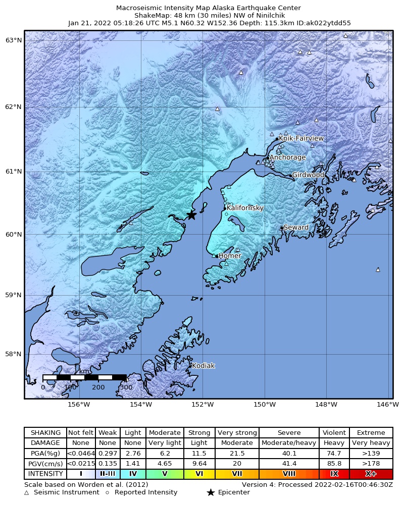
The USGS ShakeMap: shaking estimated from seismic stations and the quake’s size, on the Modified Mercalli intensity scale.
- Strongest estimated
- IV, light shaking
- Peak ground acceleration
- 2.6% of gravity
- Peak ground velocity
- -0.1 cm/s
- Map
- Automatic
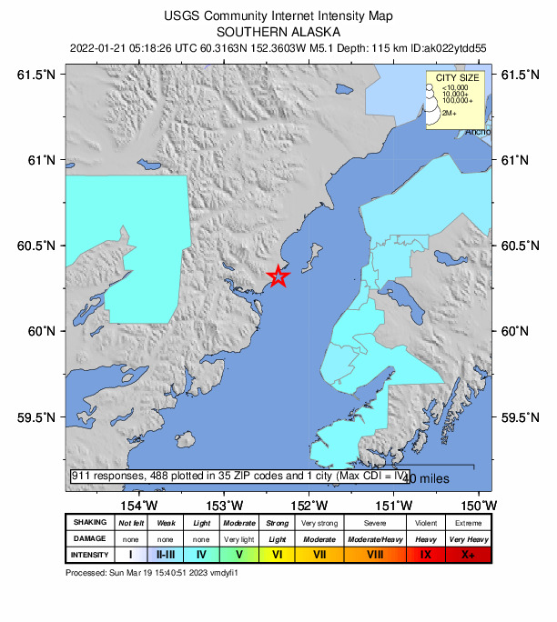
Did you feel it?
911 people reported to the USGS what they felt; the strongest reported shaking was V, moderate shaking.
Fault motion and ground failure
How the rock slipped, from the moment tensor, and the USGS estimate of landslides and liquefaction.
- Faulting
- Strike-slip
- Moment magnitude
- 5.1 Mww
- Nodal plane 1
- Strike 325°, dip 86°, rake 177°
- Nodal plane 2
- Strike 55°, dip 87°, rake 4°
How well it is located
Reviewed by a seismologist.
- Stations used
- 224
Nearest places
Distance and direction from each place to the epicenter, with its forecast.
Nearby
Within 100 km, magnitude 2.1 and up: 126 in the 60 days after this one and 47 in the 30 days before it.
After
- 2.244 km ENE of Pedro Bay, Alaska · 1714 days ago · 138 km deep · 69 km away
- 3.842 km ESE of Pedro Bay, Alaska · 1714 days ago · 113 km deep · 94 km away
- 2.759 km WNW of Nanwalek, Alaska · 1713 days ago · 99 km deep · 92 km away
- 3.164 km ESE of Pedro Bay, Alaska · 1712 days ago · 109 km deep · 97 km away
- 2.656 km WNW of Anchor Point, Alaska · 1712 days ago · 98 km deep · 44 km away
- 2.466 km WNW of Happy Valley, Alaska · 1712 days ago · 117 km deep · 37 km away
- 2.227 km ENE of Pedro Bay, Alaska · 1712 days ago · 155 km deep · 86 km away
- 3.239 km ENE of Pedro Bay, Alaska · 1711 days ago · 135 km deep · 77 km away
- 2.147 km ESE of Port Alsworth, Alaska · 1710 days ago · 160 km deep · 66 km away
- 2.147 km ESE of Port Alsworth, Alaska · 1710 days ago · 160 km deep · 66 km away
- 2.649 km ENE of Pedro Bay, Alaska · 1709 days ago · 147 km deep · 64 km away · felt by 1
- 2.931 km WNW of Nanwalek, Alaska · 1709 days ago · 88 km deep · 93 km away
- 2.246 km W of Anchor Point, Alaska · 1709 days ago · 90 km deep · 69 km away
- 2.350 km ENE of Port Alsworth, Alaska · 1709 days ago · 169 km deep · 60 km away
- 2.764 km WNW of Nikiski, Alaska · 1708 days ago · 118 km deep · 64 km away
- 2.161 km E of Port Alsworth, Alaska · 1708 days ago · 148 km deep · 48 km away
- 2.323 km E of Pedro Bay, Alaska · 1708 days ago · 145 km deep · 97 km away · felt by 1
- 2.328 km WNW of Ninilchik, Alaska · 1708 days ago · 66 km deep · 21 km away
- 3.04 km WSW of Anchor Point, Alaska · 1707 days ago · 57 km deep · 66 km away
- 3.144 km W of Anchor Point, Alaska · 1707 days ago · 82 km deep · 64 km away · felt by 1
- 2.237 km NW of Nikiski, Alaska · 1707 days ago · 79 km deep · 73 km away
- 2.228 km WNW of Anchor Point, Alaska · 1707 days ago · 72 km deep · 50 km away
- 2.218 km SE of Kasilof, Alaska · 1704 days ago · 60 km deep · 73 km away
- 2.223 km W of Tyonek, Alaska · 1704 days ago · 78 km deep · 98 km away
- 3.367 km WNW of Anchor Point, Alaska · 1703 days ago · 112 km deep · 47 km away · felt by 1
- 3.731 km ESE of Pedro Bay, Alaska · 1703 days ago · 131 km deep · 93 km away · tsunami flag
- 2.443 km WNW of Nanwalek, Alaska · 1703 days ago · 72 km deep · 98 km away
- 2.452 km E of Pedro Bay, Alaska · 1703 days ago · 107 km deep · 81 km away
- 2.431 km WNW of Nanwalek, Alaska · 1701 days ago · 72 km deep · 93 km away
- 2.749 km NE of Pedro Bay, Alaska · 1701 days ago · 155 km deep · 65 km away
- 2.567 km W of Tyonek, Alaska · 1700 days ago · 113 km deep · 81 km away
- 3.070 km W of Happy Valley, Alaska · 1700 days ago · 114 km deep · 43 km away
- 4.057 km WNW of Anchor Point, Alaska · 1700 days ago · 103 km deep · 46 km away · felt by 7 · tsunami flag
- 2.267 km W of Tyonek, Alaska · 1699 days ago · 115 km deep · 80 km away
- 2.247 km ESE of Port Alsworth, Alaska · 1697 days ago · 162 km deep · 66 km away
- 2.13 km WSW of Kasilof, Alaska · 1697 days ago · 54 km deep · 56 km away
- 2.133 km WNW of Clam Gulch, Alaska · 1697 days ago · 81 km deep · 25 km away
- 2.753 km WNW of Happy Valley, Alaska · 1696 days ago · 84 km deep · 27 km away · felt by 1
- 2.717 km E of Clam Gulch, Alaska · 1696 days ago · 63 km deep · 72 km away
- 2.356 km NW of Ninilchik, Alaska · 1696 days ago · 94 km deep · 8 km away
- 2.23 km NNW of Kachemak City, Alaska · 1696 days ago · 55 km deep · 84 km away
- 2.756 km ESE of Pedro Bay, Alaska · 1696 days ago · 100 km deep · 95 km away
- 2.262 km ENE of Pedro Bay, Alaska · 1696 days ago · 127 km deep · 51 km away
- 2.436 km ENE of Pedro Bay, Alaska · 1695 days ago · 144 km deep · 77 km away
- 2.265 km W of Tyonek, Alaska · 1694 days ago · 117 km deep · 80 km away
- 2.143 km E of Pedro Bay, Alaska · 1694 days ago · 110 km deep · 82 km away
- 2.160 km WNW of Anchor Point, Alaska · 1694 days ago · 98 km deep · 56 km away
- 2.165 km ENE of Pedro Bay, Alaska · 1693 days ago · 109 km deep · 49 km away
- 2.56 km ESE of Nikolaevsk, Alaska · 1693 days ago · 52 km deep · 76 km away
- 2.261 km W of Happy Valley, Alaska · 1693 days ago · 111 km deep · 38 km away
- 2.148 km ESE of Pedro Bay, Alaska · 1693 days ago · 104 km deep · 93 km away
- 2.163 km ESE of Pedro Bay, Alaska · 1693 days ago · 95 km deep · 95 km away
- 2.570 km WNW of Ninilchik, Alaska · 1693 days ago · 115 km deep · 31 km away
- 2.167 km W of Salamatof, Alaska · 1692 days ago · 5 km deep · 28 km away
- 3.020 km SW of Tyonek, Alaska · 1692 days ago · 85 km deep · 87 km away
- 2.354 km WNW of Nanwalek, Alaska · 1692 days ago · 90 km deep · 87 km away
- 2.322 km NNW of Ninilchik, Alaska · 1692 days ago · 72 km deep · 30 km away
- 2.435 km E of Port Alsworth, Alaska · 1692 days ago · 186 km deep · 73 km away
- 2.134 km ENE of Pedro Bay, Alaska · 1691 days ago · 130 km deep · 81 km away
- 2.832 km ESE of Pedro Bay, Alaska · 1691 days ago · 127 km deep · 97 km away
The first 60 of 126.
Before
- 2.110 km NW of Sterling, Alaska · 1716 days ago · 46 km deep · 87 km away
- 2.133 km ENE of Pedro Bay, Alaska · 1716 days ago · 153 km deep · 82 km away
- 2.454 km ENE of Pedro Bay, Alaska · 1719 days ago · 122 km deep · 59 km away
- 2.354 km WSW of Anchor Point, Alaska · 1719 days ago · 91 km deep · 75 km away
- 2.116 km N of Nikiski, Alaska · 1721 days ago · 68 km deep · 83 km away
- 2.456 km WNW of Ninilchik, Alaska · 1721 days ago · 108 km deep · 18 km away
- 2.317 km ESE of Kasilof, Alaska · 1721 days ago · 57 km deep · 77 km away
- 2.133 km WNW of Nanwalek, Alaska · 1722 days ago · 79 km deep · 91 km away
- 2.461 km ENE of Pedro Bay, Alaska · 1723 days ago · 3 km deep · 54 km away
- 3.761 km E of Port Alsworth, Alaska · 1723 days ago · 134 km deep · 50 km away · felt by 1 · tsunami flag
- 2.662 km ENE of Pedro Bay, Alaska · 1723 days ago · 5 km deep · 53 km away
- 2.560 km E of Pedro Bay, Alaska · 1724 days ago · 97 km deep · 70 km away
- 2.325 km W of Anchor Point, Alaska · 1724 days ago · 70 km deep · 56 km away
- 2.156 km WSW of Anchor Point, Alaska · 1724 days ago · 101 km deep · 77 km away
- 2.912 km ENE of Fox River, Alaska · 1725 days ago · 20 km deep · 100 km away · felt by 2
- 2.338 km ENE of Pedro Bay, Alaska · 1725 days ago · 137 km deep · 76 km away
- 2.262 km E of Pedro Bay, Alaska · 1725 days ago · 101 km deep · 67 km away
- 2.428 km WNW of Salamatof, Alaska · 1726 days ago · 75 km deep · 50 km away
- 2.628 km WNW of Kalifornsky, Alaska · 1727 days ago · 71 km deep · 36 km away
- 2.666 km WNW of Anchor Point, Alaska · 1727 days ago · 114 km deep · 45 km away
Earthquakes todayAlaska earthquakesLive radar here
Sources
From the USGS Earthquake Hazards Program and its partner networks, event ak022ytdd55 (also filed as at00r61o2q, us7000gdrq). Read Thu, Oct 1, 2026, 7:00 PM UTC.