M3.9 earthquake 34 km SE of Mina, Nevada
A magnitude 3.9 earthquake struck 34 km SE of Mina, Nevada on Thu, Jun 16, 2022, 9:55 AM PDT (16:55 UTC), 8 km (5 mi) below the surface.
Map
Where this earthquake was located, with the others nearby. Select one for its page.
The earthquake
- Magnitude
- 3.9 (Mw, moment), minor
- Magnitude from
- Nevada Seismological Laboratory
- Local time
- UTC
- 2022-06-16 16:55:23 UTC
- Depth
- 7.9 km (4.9 mi), shallow
- Epicenter
- 38.172° N, 117.823° W
- Region
- Nevada
- Felt reports
- 10
- Strongest shaking
- IV, light shaking
- PAGER alert
- Green
- Tsunami flag
- No
- Status
- Reviewed by a seismologist
Magnitude estimates
Different scales measure different things and differ by a few tenths. The USGS marks one as preferred, and it is the one this page uses.
| Mag. | Scale | Computed by | Notes |
|---|---|---|---|
| 3.9 | Mw, moment | Nevada Seismological Laboratory | Preferred · Reviewed |
| 3.9 | Mwr, regional moment | USGS National Earthquake Information Center | Reviewed · ±0.027 · 136 stations |
Shaking
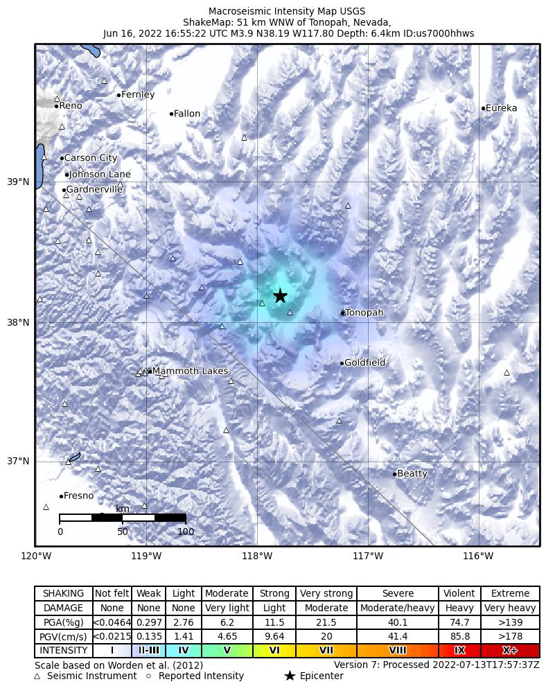
The USGS ShakeMap: shaking estimated from seismic stations and the quake’s size, on the Modified Mercalli intensity scale.
- Strongest estimated
- IV, light shaking
- Peak ground acceleration
- 6.2% of gravity
- Peak ground velocity
- 1.7 cm/s
- Map
- Automatic
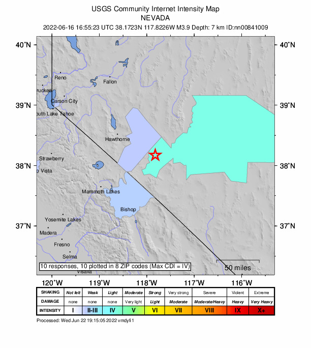
Did you feel it?
10 people reported to the USGS what they felt; the strongest reported shaking was IV, light shaking.
Estimated impact
The USGS PAGER system estimates deaths and economic losses from the shaking and the population and buildings exposed to it.
- Alert level
- Green: little or no damage or loss of life expected
| Range | Chance |
|---|---|
| Under 1 | 65% |
| 1 to 10 | 30% |
| 10 to 100 | 4% |
| 100 to 1,000 | Under 1% |
| 1,000 to 10,000 | Under 1% |
| 10,000 to 100,000 | Under 1% |
| 100,000 to 10,000,000 | Under 1% |
| Range, million USD | Chance |
|---|---|
| Under 1 | 65% |
| 1 to 10 | 30% |
| 10 to 100 | 4% |
| 100 to 1,000 | Under 1% |
| 1,000 to 10,000 | Under 1% |
| 10,000 to 100,000 | Under 1% |
| 100,000 to 10,000,000 | Under 1% |
Fault motion and ground failure
How the rock slipped, from the moment tensor, and the USGS estimate of landslides and liquefaction.
- Faulting
- Strike-slip
- Nodal plane 1
- Strike 356°, dip 64°, rake -180°
- Nodal plane 2
- Strike 266°, dip 90°, rake -26°
How well it is located
Reviewed by a seismologist.
- Station coverage gap
- 40°
- Stations used
- 28
Nearest places
Distance and direction from each place to the epicenter, with its forecast.
Nearby
Within 100 km, magnitude 1.5 and up: 88 in the 60 days after this one and 35 in the 30 days before it.
After
- 1.834 km SE of Mina, Nevada · 1571 days ago · 8 km deep · 0 km away
- 1.935 km SE of Mina, Nevada · 1571 days ago · 8 km deep · 0 km away
- 1.835 km SE of Mina, Nevada · 1571 days ago · 8 km deep · 1 km away
- 2.134 km SE of Mina, Nevada · 1570 days ago · 8 km deep · 1 km away
- 1.533 km SE of Mina, Nevada · 1570 days ago · 7 km deep · 1 km away
- 1.535 km SE of Mina, Nevada · 1570 days ago · 8 km deep · 1 km away
- 1.527 km SW of Mina, Nevada · 1570 days ago · 11 km deep · 48 km away
- 2.035 km SE of Mina, Nevada · 1570 days ago · 9 km deep · 1 km away
- 1.634 km SE of Mina, Nevada · 1570 days ago · 8 km deep · 1 km away
- 1.929 km SSE of Mina, Nevada · 1570 days ago · 10 km deep · 12 km away
- 1.527 km SSE of Mina, Nevada · 1569 days ago · 4 km deep · 16 km away
- 1.935 km SE of Mina, Nevada · 1569 days ago · 9 km deep · 1 km away
- 1.5Nevada · 1569 days ago · 8 km deep · 0 km away
- 1.535 km SE of Mina, Nevada · 1569 days ago · 9 km deep · 1 km away
- 2.035 km SE of Mina, Nevada · 1569 days ago · 9 km deep · 0 km away
- 1.726 km SW of Mina, Nevada · 1568 days ago · 8 km deep · 48 km away
- 2.434 km SE of Mina, Nevada · 1567 days ago · 8 km deep · 0 km away
- 2.432 km SE of Mina, Nevada · 1566 days ago · 8 km deep · 6 km away
- 1.933 km SSW of Mina, Nevada · 1565 days ago · 11 km deep · 37 km away
- 2.330 km SE of Mina, Nevada · 1564 days ago · 11 km deep · 5 km away
- 1.532 km SE of Mina, Nevada · 1563 days ago · 7 km deep · 5 km away
- 1.954km ENE of Big Pine, CA · 1563 days ago · 1 km deep · 100 km away
- 1.732 km SSW of Mina, Nevada · 1561 days ago · 2 km deep · 37 km away
- 1.734 km SE of Mina, Nevada · 1559 days ago · 8 km deep · 0 km away
- 1.734 km SE of Mina, Nevada · 1559 days ago · 8 km deep · 0 km away
- 1.534 km SE of Mina, Nevada · 1559 days ago · 8 km deep · 1 km away
- 2.230 km SE of Mina, Nevada · 1559 days ago · 10 km deep · 6 km away
- 2.230 km SE of Mina, Nevada · 1557 days ago · 10 km deep · 7 km away
- 3.935 km SE of Mina, Nevada · 1557 days ago · 8 km deep · 6 km away · felt by 1
- 1.628 km S of Mina, Nevada · 1557 days ago · 3 km deep · 24 km away
- 1.835 km ESE of Mina, Nevada · 1557 days ago · 6 km deep · 7 km away
- 2.233 km SE of Mina, Nevada · 1556 days ago · 8 km deep · 6 km away
- 1.534 km SE of Mina, Nevada · 1552 days ago · 8 km deep · 1 km away
- 1.526 km SSW of Mina, Nevada · 1552 days ago · 9 km deep · 32 km away
- 2.130 km SE of Mina, Nevada · 1552 days ago · 10 km deep · 7 km away
- 2.018 km NE of Hawthorne, Nevada · 1552 days ago · 0 km deep · 75 km away
- 1.739km NNE of Toms Place, CA · 1551 days ago · 8 km deep · 70 km away
- 1.625 km SSW of Mina, Nevada · 1550 days ago · 8 km deep · 33 km away
- 1.526 km SSW of Mina, Nevada · 1550 days ago · 9 km deep · 33 km away
- 2.028 km SSE of Mina, Nevada · 1550 days ago · 5 km deep · 16 km away
- 2.17km SE of Deep Springs, CA · 1550 days ago · 11 km deep · 94 km away
- 1.828 km NNW of Benton, California · 1549 days ago · 9 km deep · 70 km away
- 1.929 km SE of Mina, Nevada · 1546 days ago · 9 km deep · 6 km away
- 1.530 km SE of Mina, Nevada · 1545 days ago · 9 km deep · 5 km away
- 1.631 km SE of Mina, Nevada · 1544 days ago · 11 km deep · 4 km away
- 2.723 km SSW of Mina, Nevada · 1542 days ago · 10 km deep · 30 km away
- 1.621 km NE of Goldfield, Nevada · 1541 days ago · 0 km deep · 72 km away
- 1.937 km W of Gabbs, Nevada · 1541 days ago · 11 km deep · 90 km away
- 2.431 km SE of Mina, Nevada · 1540 days ago · 8 km deep · 5 km away
- 2.134km SSW of Qualeys Camp, NV · 1540 days ago · 10 km deep · 75 km away
- 2.244km NNE of Toms Place, CA · 1538 days ago · 9 km deep · 63 km away
- 3.144km NNE of Toms Place, CA · 1538 days ago · 10 km deep · 62 km away · felt by 3
- 2.134 km SE of Mina, Nevada · 1538 days ago · 8 km deep · 0 km away
- 1.532 km SE of Mina, Nevada · 1537 days ago · 11 km deep · 3 km away
- 1.629 km SSE of Mina, Nevada · 1537 days ago · 12 km deep · 11 km away
- 1.628 km SSE of Mina, Nevada · 1536 days ago · 8 km deep · 15 km away
- 1.634 km SE of Mina, Nevada · 1536 days ago · 6 km deep · 0 km away
- 1.920km SE of Bodie, CA · 1536 days ago · 9 km deep · 90 km away
- 1.612 km NNE of Benton, California · 1536 days ago · 14 km deep · 61 km away
- 2.317km SSE of Bodie, CA · 1535 days ago · 9 km deep · 96 km away
The first 60 of 88.
Before
- 1.829 km SE of Mina, Nevada · 1572 days ago · 8 km deep · 5 km away
- 1.518 km NE of Mina, Nevada · 1572 days ago · 1 km deep · 36 km away
- 1.830 km SSE of Mina, Nevada · 1575 days ago · 2 km deep · 16 km away
- 1.830 km SSE of Mina, Nevada · 1575 days ago · 5 km deep · 16 km away
- 3.018 km NE of Mina, Nevada · 1578 days ago · 4 km deep · 36 km away · felt by 2
- 1.530 km SE of Mina, Nevada · 1578 days ago · 7 km deep · 5 km away
- 2.643km S of Qualeys Camp, NV · 1580 days ago · 7 km deep · 67 km away
- 2.142km S of Qualeys Camp, NV · 1581 days ago · 6 km deep · 68 km away
- 1.54km NW of Dixon Lane-Meadow Creek, CA · 1582 days ago · 5 km deep · 100 km away
- 1.5Nevada · 1582 days ago · 8 km deep · 5 km away
- 2.417 km S of Mina, Nevada · 1583 days ago · 2 km deep · 28 km away
- 1.834 km SE of Mina, Nevada · 1583 days ago · 4 km deep · 1 km away
- 2.135 km SE of Mina, Nevada · 1583 days ago · 4 km deep · 3 km away
- 1.729 km SE of Mina, Nevada · 1584 days ago · 4 km deep · 6 km away
- 3.430 km SE of Mina, Nevada · 1585 days ago · 4 km deep · 5 km away · felt by 2
- 2.332 km SE of Mina, Nevada · 1585 days ago · 8 km deep · 5 km away
- 1.631 km SE of Mina, Nevada · 1587 days ago · 10 km deep · 6 km away
- 2.829 km S of Mina, Nevada · 1587 days ago · 11 km deep · 25 km away · felt by 1
- 2.25km ENE of Dixon Lane-Meadow Creek, CA · 1589 days ago · 4 km deep · 98 km away · felt by 2
- 2.235 km SE of Mina, Nevada · 1590 days ago · 8 km deep · 1 km away
Earthquakes todayNevada earthquakesLive radar here
Sources
From the USGS Earthquake Hazards Program and its partner networks, event nn00841009 (also filed as us7000hhws). Read Sun, Oct 4, 2026, 10:58 AM UTC.