M3.1 earthquake 63 km W of Anchor Point, Alaska
A magnitude 3.1 earthquake struck 63 km W of Anchor Point, Alaska on Fri, Aug 12, 2022, 3:49 PM AKDT (23:49 UTC), 111 km (69 mi) below the surface.
A larger quake followed: M4.6 64 km WNW of Anchor Point, Alaska. This one was a foreshock.
Map
Where this earthquake was located, with the others nearby. Select one for its page.
The earthquake
- Magnitude
- 3.1 (ML, local (Richter)), minor
- Magnitude from
- Alaska Earthquake Center
- Local time
- UTC
- 2022-08-12 23:49:58 UTC
- Depth
- 111.1 km (69.0 mi), intermediate-depth
- Epicenter
- 59.853° N, 152.951° W
- Region
- Alaska
- Felt reports
- 1
- Tsunami flag
- No
- Status
- Reviewed by a seismologist
Magnitude estimates
Different scales measure different things and differ by a few tenths. The USGS marks one as preferred, and it is the one this page uses.
| Mag. | Scale | Computed by | Notes |
|---|---|---|---|
| 3.1 | ML, local (Richter) | Alaska Earthquake Center | Preferred · Preliminary |
| 3.4 | ML, local (Richter) | USGS National Earthquake Information Center | Reviewed · ±0.031 · 138 stations |
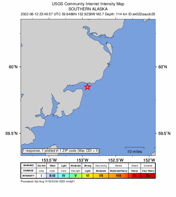
Did you feel it?
1 person reported to the USGS what they felt; the strongest reported shaking was II, weak shaking.
How well it is located
Reviewed by a seismologist.
- Stations used
- 176
Nearest places
Distance and direction from each place to the epicenter, with its forecast.
Nearby
Within 100 km, magnitude 1.5 and up: at least 202 in the 60 days after this one and at least 200 in the 30 days before it.
After
- 3.255 km E of Pedro Bay, Alaska · 1512 days ago · 103 km deep · 16 km away
- 1.657 km E of Port Alsworth, Alaska · 1512 days ago · 136 km deep · 42 km away
- 1.546 km WSW of Salamatof, Alaska · 1512 days ago · 70 km deep · 84 km away
- 2.166 km ESE of Pedro Bay, Alaska · 1512 days ago · 106 km deep · 44 km away
- 1.850 km W of Happy Valley, Alaska · 1512 days ago · 93 km deep · 28 km away
- 1.738 km WNW of Anchor Point, Alaska · 1512 days ago · 70 km deep · 26 km away
- 3.869 km ENE of Pedro Bay, Alaska · 1512 days ago · 106 km deep · 23 km away · felt by 2
- 2.474 km WNW of Ninilchik, Alaska · 1511 days ago · 102 km deep · 46 km away
- 1.842 km W of Nanwalek, Alaska · 1511 days ago · 68 km deep · 65 km away
- 1.763 km W of Happy Valley, Alaska · 1511 days ago · 105 km deep · 21 km away
- 1.543 km W of Anchor Point, Alaska · 1511 days ago · 87 km deep · 22 km away
- 1.816 km SSE of Pedro Bay, Alaska · 1510 days ago · 10 km deep · 63 km away
- 1.547 km E of Pedro Bay, Alaska · 1510 days ago · 131 km deep · 18 km away
- 2.959 km WNW of Anchor Point, Alaska · 1510 days ago · 90 km deep · 16 km away
- 2.011 km WNW of Happy Valley, Alaska · 1510 days ago · 57 km deep · 61 km away
- 1.69 km ENE of Pedro Bay, Alaska · 1510 days ago · 164 km deep · 56 km away
- 1.739 km NW of Ninilchik, Alaska · 1510 days ago · 91 km deep · 67 km away
- 3.221 km WNW of Anchor Point, Alaska · 1509 days ago · 73 km deep · 43 km away · felt by 10
- 1.651 km WNW of Ninilchik, Alaska · 1509 days ago · 102 km deep · 56 km away
- 1.561 km ESE of Pedro Bay, Alaska · 1509 days ago · 90 km deep · 28 km away
- 1.666 km E of Port Alsworth, Alaska · 1509 days ago · 128 km deep · 44 km away
- 1.913 km E of Ninilchik, Alaska · 1509 days ago · 50 km deep · 88 km away
- 1.566 km W of Nanwalek, Alaska · 1509 days ago · 89 km deep · 57 km away
- 4.2Southern Alaska · 1509 days ago · 72 km deep · 84 km away · felt by 31 · tsunami flag
- 1.646 km NW of Ninilchik, Alaska · 1508 days ago · 92 km deep · 61 km away
- 1.663 km ESE of Pedro Bay, Alaska · 1508 days ago · 89 km deep · 31 km away
- 1.660 km E of Pedro Bay, Alaska · 1508 days ago · 101 km deep · 5 km away
- 1.971 km WNW of Happy Valley, Alaska · 1508 days ago · 123 km deep · 26 km away
- 1.867 km WNW of Happy Valley, Alaska · 1508 days ago · 111 km deep · 27 km away
- 1.737 km SE of Pedro Bay, Alaska · 1508 days ago · 120 km deep · 48 km away
- 1.656 km WNW of Happy Valley, Alaska · 1508 days ago · 102 km deep · 28 km away
- 1.941 km ESE of Pope-Vannoy Landing, Alaska · 1508 days ago · 122 km deep · 66 km away
- 1.760 km W of Anchor Point, Alaska · 1508 days ago · 103 km deep · 3 km away
- 1.667 km W of Nanwalek, Alaska · 1508 days ago · 84 km deep · 58 km away
- 1.845 km E of Pedro Bay, Alaska · 1508 days ago · 134 km deep · 20 km away
- 1.768 km WNW of Happy Valley, Alaska · 1507 days ago · 107 km deep · 28 km away
- 1.660 km E of Pedro Bay, Alaska · 1507 days ago · 103 km deep · 5 km away
- 1.532 km WSW of Salamatof, Alaska · 1507 days ago · 76 km deep · 94 km away
- 2.157 km E of Pedro Bay, Alaska · 1507 days ago · 102 km deep · 8 km away
- 1.770 km WNW of Happy Valley, Alaska · 1507 days ago · 118 km deep · 36 km away
- 1.518 km NW of Ninilchik, Alaska · 1506 days ago · 62 km deep · 71 km away
- 1.662 km ENE of Pedro Bay, Alaska · 1506 days ago · 127 km deep · 8 km away
- 1.662 km ESE of Pope-Vannoy Landing, Alaska · 1506 days ago · 100 km deep · 71 km away
- 1.562 km W of Anchor Point, Alaska · 1506 days ago · 105 km deep · 3 km away
- 1.946 km WNW of Nanwalek, Alaska · 1506 days ago · 81 km deep · 46 km away
- 1.633 km WSW of Anchor Point, Alaska · 1506 days ago · 72 km deep · 39 km away
- 2.262 km E of Pedro Bay, Alaska · 1506 days ago · 98 km deep · 3 km away
- 1.867 km NW of Ninilchik, Alaska · 1506 days ago · 102 km deep · 70 km away
- 1.651 km WSW of Anchor Point, Alaska · 1505 days ago · 87 km deep · 30 km away
- 1.663 km E of Pedro Bay, Alaska · 1505 days ago · 90 km deep · 11 km away
- 1.652 km WNW of Nanwalek, Alaska · 1505 days ago · 76 km deep · 39 km away
- 2.144 km ESE of Port Alsworth, Alaska · 1505 days ago · 171 km deep · 44 km away
- 2.269 km NW of Ninilchik, Alaska · 1505 days ago · 104 km deep · 73 km away
- 2.238 km E of Pedro Bay, Alaska · 1505 days ago · 123 km deep · 26 km away
- 2.066 km W of Happy Valley, Alaska · 1505 days ago · 119 km deep · 23 km away
- 2.2Southern Alaska · 1505 days ago · 69 km deep · 92 km away
- 2.249 km NE of Pedro Bay, Alaska · 1505 days ago · 134 km deep · 31 km away
- 1.948 km SE of Pedro Bay, Alaska · 1505 days ago · 112 km deep · 58 km away
- 1.8Southern Alaska · 1505 days ago · 111 km deep · 85 km away
- 2.057 km WNW of Anchor Point, Alaska · 1505 days ago · 100 km deep · 8 km away
The first 60 of at least 202.
Before
- 1.845 km NW of Ninilchik, Alaska · 1513 days ago · 91 km deep · 60 km away
- 1.749 km W of Anchor Point, Alaska · 1513 days ago · 78 km deep · 17 km away
- 1.658 km W of Happy Valley, Alaska · 1513 days ago · 89 km deep · 23 km away
- 1.66 km NNE of Fritz Creek, Alaska · 1513 days ago · 56 km deep · 96 km away
- 2.868 km E of Port Alsworth, Alaska · 1513 days ago · 108 km deep · 33 km away
- 1.853 km WNW of Anchor Point, Alaska · 1513 days ago · 99 km deep · 16 km away
- 1.737 km W of Nanwalek, Alaska · 1513 days ago · 70 km deep · 57 km away
- 1.760 km WNW of Nanwalek, Alaska · 1513 days ago · 89 km deep · 37 km away
- 1.615 km NNW of Ninilchik, Alaska · 1513 days ago · 72 km deep · 77 km away
- 2.0Southern Alaska · 1513 days ago · 116 km deep · 17 km away
- 2.153 km E of Pedro Bay, Alaska · 1513 days ago · 104 km deep · 18 km away
- 2.157 km E of Port Alsworth, Alaska · 1514 days ago · 140 km deep · 41 km away
- 1.7Southern Alaska · 1514 days ago · 92 km deep · 81 km away
- 1.969 km ENE of Pedro Bay, Alaska · 1514 days ago · 112 km deep · 23 km away
- 1.953 km NW of Ninilchik, Alaska · 1514 days ago · 98 km deep · 62 km away
- 1.654 km WNW of Nanwalek, Alaska · 1514 days ago · 77 km deep · 36 km away
- 2.57 km N of Nikolaevsk, Alaska · 1514 days ago · 71 km deep · 75 km away · felt by 1
- 2.265 km E of Port Alsworth, Alaska · 1514 days ago · 144 km deep · 48 km away
- 1.551 km WNW of Ninilchik, Alaska · 1514 days ago · 93 km deep · 58 km away
- 1.551 km WNW of Happy Valley, Alaska · 1514 days ago · 96 km deep · 33 km away
Earthquakes todayAlaska earthquakesLive radar here
Sources
From the USGS Earthquake Hazards Program and its partner networks, event ak022aaudc35 (also filed as us6000iaeh). Read Sat, Oct 3, 2026, 2:48 PM UTC.