M4.7 earthquake 43 km SSW of Adak, Alaska
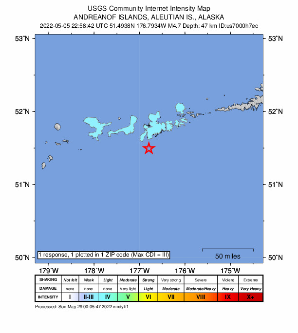
A magnitude 4.7 earthquake struck 43 km SSW of Adak, Alaska on Thu, May 5, 2022, 1:58 PM HADT (22:58 UTC), 47 km (29 mi) below the surface.
Map
Where this earthquake was located, with the others nearby. Select one for its page.
The earthquake
- Magnitude
- 4.7 (mb), light
- Local time
- UTC
- 2022-05-05 22:58:42 UTC
- Depth
- 47.1 km (29.2 mi), shallow
- Epicenter
- 51.498° N, 176.801° W
- Region
- Alaska
- Felt reports
- 1
- Tsunami flag
- No
- Status
- Reviewed by a seismologist
Did you feel it?
1 person reported to the USGS what they felt; the strongest reported shaking was III, weak shaking.
How well it is located
Reviewed by a seismologist.
- Location uncertainty
- About 5.0 km horizontally, 4.8 km in depth
- Magnitude uncertainty
- ±0.03
- Depth from
- From location
- Station coverage gap
- 129°
- Stations used
- 103
Nearby
Within 100 km, magnitude 1.7 and up: 123 in the 60 days after this one and 69 in the 30 days before it.
After
- 1.7103 km WSW of Adak, Alaska · 1608 days ago · 67 km deep · 86 km away
- 1.765 km SE of Adak, Alaska · 1608 days ago · 21 km deep · 50 km away
- 1.859 km SSE of Adak, Alaska · 1607 days ago · 21 km deep · 42 km away
- 2.864 km SSE of Adak, Alaska · 1606 days ago · 35 km deep · 44 km away
- 2.057 km NE of Adak, Alaska · 1605 days ago · 167 km deep · 97 km away
- 1.765 km SSE of Adak, Alaska · 1604 days ago · 21 km deep · 36 km away
- 3.47 km SE of Adak, Alaska · 1603 days ago · 10 km deep · 40 km away · felt by 1
- 1.986 km SW of Adak, Alaska · 1603 days ago · 39 km deep · 60 km away
- 3.867 km SW of Adak, Alaska · 1602 days ago · 67 km deep · 44 km away
- 3.287 km SSE of Adak, Alaska · 1601 days ago · 24 km deep · 53 km away
- 1.780 km SSE of Adak, Alaska · 1601 days ago · 14 km deep · 47 km away
- 2.026 km E of Adak, Alaska · 1601 days ago · 180 km deep · 53 km away
- 2.654 km SE of Adak, Alaska · 1600 days ago · 38 km deep · 42 km away
- 1.7126 km SW of Adak, Alaska · 1600 days ago · 16 km deep · 96 km away
- 1.950 km NE of Adak, Alaska · 1600 days ago · 151 km deep · 89 km away
- 1.764 km SE of Adak, Alaska · 1599 days ago · 30 km deep · 61 km away
- 1.857 km ESE of Adak, Alaska · 1599 days ago · 59 km deep · 72 km away
- 1.8111 km WSW of Adak, Alaska · 1598 days ago · 13 km deep · 94 km away
- 1.728 km ESE of Adak, Alaska · 1598 days ago · 68 km deep · 47 km away
- 3.259 km SSW of Adak, Alaska · 1597 days ago · 39 km deep · 22 km away
- 1.823 km SE of Adak, Alaska · 1597 days ago · 70 km deep · 42 km away
- 1.865 km SE of Adak, Alaska · 1597 days ago · 27 km deep · 55 km away
- 2.059 km SSE of Adak, Alaska · 1596 days ago · 39 km deep · 44 km away
- 2.667 km S of Adak, Alaska · 1596 days ago · 34 km deep · 31 km away
- 1.985 km W of Adak, Alaska · 1594 days ago · 186 km deep · 90 km away
- 2.757 km ESE of Adak, Alaska · 1594 days ago · 42 km deep · 62 km away
- 3.273 km SW of Adak, Alaska · 1594 days ago · 44 km deep · 41 km away
- 2.045 km ESE of Adak, Alaska · 1593 days ago · 69 km deep · 64 km away
- 2.648 km S of Adak, Alaska · 1593 days ago · 33 km deep · 18 km away
- 2.04 km ENE of Adak, Alaska · 1593 days ago · 5 km deep · 46 km away
- 1.9124 km SW of Adak, Alaska · 1592 days ago · 19 km deep · 86 km away
- 1.791 km WSW of Adak, Alaska · 1592 days ago · 61 km deep · 72 km away
- 2.460 km NE of Adak, Alaska · 1591 days ago · 184 km deep · 100 km away
- 2.045 km ENE of Adak, Alaska · 1591 days ago · 124 km deep · 78 km away
- 2.686 km SW of Adak, Alaska · 1591 days ago · 35 km deep · 48 km away
- 1.769 km ESE of Adak, Alaska · 1590 days ago · 58 km deep · 82 km away
- 2.959 km SSW of Adak, Alaska · 1590 days ago · 34 km deep · 20 km away
- 1.855 km SSW of Adak, Alaska · 1590 days ago · 39 km deep · 19 km away
- 1.725 km SE of Adak, Alaska · 1589 days ago · 63 km deep · 35 km away
- 3.4131 km SW of Adak, Alaska · 1589 days ago · 35 km deep · 95 km away
- 1.881 km E of Adak, Alaska · 1588 days ago · 61 km deep · 96 km away
- 2.166 km ENE of Adak, Alaska · 1588 days ago · 143 km deep · 99 km away
- 3.470 km SSW of Adak, Alaska · 1588 days ago · 35 km deep · 28 km away
- 3.650 km NE of Adak, Alaska · 1586 days ago · 136 km deep · 90 km away
- 2.6100 km WSW of Adak, Alaska · 1586 days ago · 64 km deep · 79 km away
- 1.754 km S of Adak, Alaska · 1586 days ago · 38 km deep · 13 km away
- 2.963 km SSW of Adak, Alaska · 1586 days ago · 35 km deep · 20 km away
- 3.083 km SE of Adak, Alaska · 1585 days ago · 36 km deep · 75 km away
- 1.944 km ENE of Adak, Alaska · 1585 days ago · 188 km deep · 76 km away
- 1.9120 km WSW of Adak, Alaska · 1584 days ago · 33 km deep · 95 km away
- 1.871 km SE of Adak, Alaska · 1584 days ago · 44 km deep · 64 km away
- 3.146 km WSW of Adak, Alaska · 1583 days ago · 102 km deep · 44 km away
- 2.5120 km SW of Adak, Alaska · 1583 days ago · 37 km deep · 91 km away
- 3.370 km SSE of Adak, Alaska · 1583 days ago · 35 km deep · 53 km away
- 1.855 km SSE of Adak, Alaska · 1583 days ago · 21 km deep · 34 km away
- 1.969 km ESE of Adak, Alaska · 1582 days ago · 34 km deep · 71 km away
- 2.699 km WSW of Adak, Alaska · 1581 days ago · 65 km deep · 79 km away
- 2.7104 km WSW of Adak, Alaska · 1579 days ago · 63 km deep · 85 km away
- 1.749 km SSW of Adak, Alaska · 1578 days ago · 35 km deep · 13 km away
- 1.9Andreanof Islands, Aleutian Islands, Alaska · 1577 days ago · 29 km deep · 10 km away
The first 60 of 123.
Before
- 1.889 km SW of Adak, Alaska · 1608 days ago · 26 km deep · 56 km away
- 3.552 km S of Adak, Alaska · 1608 days ago · 35 km deep · 10 km away
- 1.7119 km WSW of Adak, Alaska · 1608 days ago · 13 km deep · 99 km away
- 1.7104 km WSW of Adak, Alaska · 1610 days ago · 29 km deep · 82 km away
- 2.6120 km SW of Adak, Alaska · 1610 days ago · 27 km deep · 88 km away
- 2.5112 km SW of Adak, Alaska · 1610 days ago · 35 km deep · 79 km away
- 1.870 km SSW of Adak, Alaska · 1610 days ago · 27 km deep · 29 km away
- 2.053 km SSW of Adak, Alaska · 1610 days ago · 35 km deep · 17 km away
- 1.952 km S of Adak, Alaska · 1611 days ago · 29 km deep · 13 km away
- 2.162 km SSE of Adak, Alaska · 1612 days ago · 46 km deep · 46 km away
- 2.757 km ENE of Adak, Alaska · 1613 days ago · 237 km deep · 92 km away
- 1.856 km SSE of Adak, Alaska · 1613 days ago · 8 km deep · 42 km away
- 1.956 km SSE of Adak, Alaska · 1614 days ago · 23 km deep · 42 km away
- 1.866 km S of Adak, Alaska · 1615 days ago · 18 km deep · 29 km away
- 2.162 km SSE of Adak, Alaska · 1615 days ago · 26 km deep · 31 km away
- 2.655 km SSE of Adak, Alaska · 1616 days ago · 33 km deep · 42 km away
- 1.945 km SW of Adak, Alaska · 1618 days ago · 29 km deep · 23 km away
- 1.741 km SW of Adak, Alaska · 1618 days ago · 17 km deep · 29 km away
- 1.9119 km WSW of Adak, Alaska · 1618 days ago · 19 km deep · 99 km away
- 2.549 km SSE of Adak, Alaska · 1619 days ago · 35 km deep · 31 km away
Earthquakes todayAlaska earthquakesLive radar here
Sources
From the USGS Earthquake Hazards Program and its partner networks, event us7000h7ec (also filed as ak0225r3mfq2). Read Tue, Sep 29, 2026, 6:55 PM UTC.