M4.2 earthquake 244 km W of Adak, Alaska
A magnitude 4.2 earthquake struck 244 km W of Adak, Alaska on Sun, Aug 21, 2022, 3:47 PM GMT+12 (03:47 UTC), 88 km (55 mi) below the surface.
A larger quake followed: M4.6 210 km WSW of Adak, Alaska. This one was a foreshock.
Map
Where this earthquake was located, with the others nearby. Select one for its page.
The earthquake
- Magnitude
- 4.2 (mb), light
- Local time
- UTC
- 2022-08-21 03:47:46 UTC
- Depth
- 88.3 km (54.8 mi), intermediate-depth
- Epicenter
- 51.499° N, 179.876° E
- Region
- Alaska
- Strongest shaking
- III, weak shaking
- Tsunami flag
- No
- Status
- Reviewed by a seismologist
Shaking
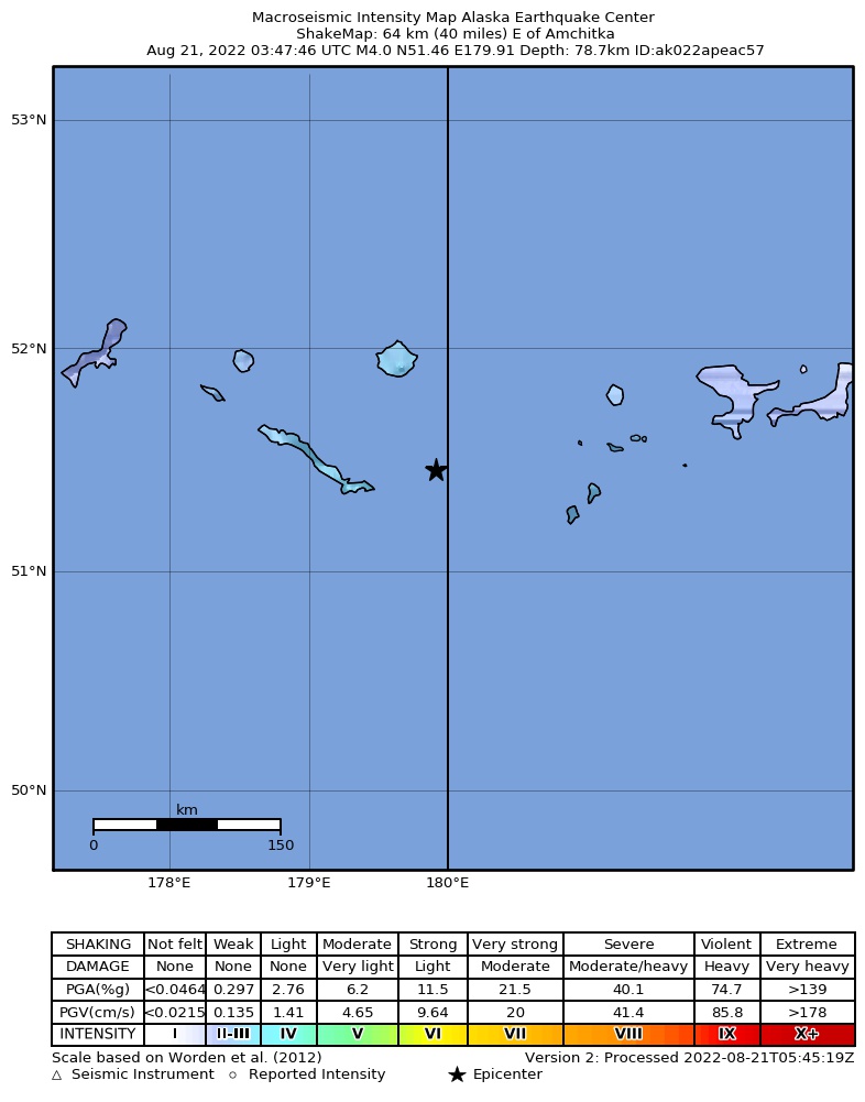
The USGS ShakeMap: shaking estimated from seismic stations and the quake’s size, on the Modified Mercalli intensity scale.
- Strongest estimated
- III, weak shaking
- Peak ground acceleration
- 0.4% of gravity
- Peak ground velocity
- -3.0 cm/s
- Map
- Automatic
Did you feel it?
No one has reported feeling this quake to the USGS.
How well it is located
Reviewed by a seismologist.
- Location uncertainty
- About 4.7 km horizontally, 4.5 km in depth
- Magnitude uncertainty
- ±0.04
- Depth from
- From location
- Station coverage gap
- 135°
- Stations used
- 74
Nearby
Within 100 km, magnitude 1.5 and up: 117 in the 60 days after this one and 78 in the 30 days before it.
After
- 3.3Rat Islands, Aleutian Islands, Alaska · 1501 days ago · 74 km deep · 65 km away
- 1.8210 km W of Adak, Alaska · 1501 days ago · 72 km deep · 39 km away
- 1.8Rat Islands, Aleutian Islands, Alaska · 1501 days ago · 36 km deep · 61 km away
- 1.6177 km WSW of Adak, Alaska · 1501 days ago · 18 km deep · 95 km away
- 2.7Rat Islands, Aleutian Islands, Alaska · 1500 days ago · 86 km deep · 95 km away
- 2.5258 km W of Adak, Alaska · 1499 days ago · 97 km deep · 33 km away
- 1.8235 km WSW of Adak, Alaska · 1499 days ago · 15 km deep · 31 km away
- 1.7259 km W of Adak, Alaska · 1498 days ago · 5 km deep · 55 km away
- 1.8170 km WSW of Adak, Alaska · 1498 days ago · 22 km deep · 76 km away
- 1.8168 km W of Adak, Alaska · 1498 days ago · 7 km deep · 78 km away
- 1.7258 km W of Adak, Alaska · 1498 days ago · 9 km deep · 55 km away
- 1.6258 km W of Adak, Alaska · 1498 days ago · 8 km deep · 53 km away
- 2.9Rat Islands, Aleutian Islands, Alaska · 1497 days ago · 101 km deep · 98 km away
- 3.1264 km W of Adak, Alaska · 1496 days ago · 64 km deep · 20 km away
- 2.8Andreanof Islands, Aleutian Islands, Alaska · 1496 days ago · 109 km deep · 68 km away
- 1.9155 km WSW of Adak, Alaska · 1496 days ago · 60 km deep · 90 km away
- 1.9175 km WSW of Adak, Alaska · 1496 days ago · 24 km deep · 91 km away
- 1.6298 km W of Adak, Alaska · 1495 days ago · 61 km deep · 55 km away
- 3.0Rat Islands, Aleutian Islands, Alaska · 1495 days ago · 81 km deep · 80 km away
- 1.8Rat Islands, Aleutian Islands, Alaska · 1494 days ago · 25 km deep · 69 km away
- 1.8271 km W of Adak, Alaska · 1494 days ago · 67 km deep · 27 km away
- 3.5219 km W of Adak, Alaska · 1494 days ago · 196 km deep · 50 km away
- 1.6225 km W of Adak, Alaska · 1493 days ago · 6 km deep · 24 km away
- 3.7205 km WSW of Adak, Alaska · 1492 days ago · 40 km deep · 74 km away
- 3.0186 km WSW of Adak, Alaska · 1492 days ago · 31 km deep · 65 km away
- 3.9252 km W of Adak, Alaska · 1492 days ago · 135 km deep · 52 km away
- 2.0189 km WSW of Adak, Alaska · 1491 days ago · 36 km deep · 72 km away
- 1.8Rat Islands, Aleutian Islands, Alaska · 1490 days ago · 56 km deep · 86 km away
- 2.0194 km W of Adak, Alaska · 1490 days ago · 55 km deep · 52 km away
- 1.8242 km WSW of Adak, Alaska · 1489 days ago · 52 km deep · 8 km away
- 3.9Rat Islands, Aleutian Islands, Alaska · 1489 days ago · 100 km deep · 90 km away
- 1.7157 km WSW of Adak, Alaska · 1489 days ago · 26 km deep · 95 km away
- 2.5166 km WSW of Adak, Alaska · 1488 days ago · 25 km deep · 88 km away
- 2.5232 km W of Adak, Alaska · 1488 days ago · 16 km deep · 27 km away
- 2.6206 km W of Adak, Alaska · 1486 days ago · 105 km deep · 47 km away
- 1.9Rat Islands, Aleutian Islands, Alaska · 1486 days ago · 16 km deep · 86 km away
- 1.9207 km WSW of Adak, Alaska · 1486 days ago · 9 km deep · 78 km away
- 2.3228 km W of Adak, Alaska · 1486 days ago · 91 km deep · 32 km away
- 2.7262 km WSW of Adak, Alaska · 1485 days ago · 28 km deep · 34 km away
- 1.8294 km W of Adak, Alaska · 1485 days ago · 86 km deep · 65 km away
- 3.3254 km WSW of Adak, Alaska · 1485 days ago · 31 km deep · 30 km away
- 2.7Rat Islands, Aleutian Islands, Alaska · 1485 days ago · 88 km deep · 100 km away
- 2.8207 km W of Adak, Alaska · 1485 days ago · 168 km deep · 80 km away
- 2.8Rat Islands, Aleutian Islands, Alaska · 1484 days ago · 106 km deep · 78 km away
- 1.9252 km WSW of Adak, Alaska · 1484 days ago · 15 km deep · 14 km away
- 1.8160 km WSW of Adak, Alaska · 1483 days ago · 24 km deep · 93 km away
- 2.1171 km WSW of Adak, Alaska · 1483 days ago · 22 km deep · 80 km away
- 1.8234 km W of Adak, Alaska · 1483 days ago · 13 km deep · 32 km away
- 2.8261 km WSW of Adak, Alaska · 1483 days ago · 10 km deep · 18 km away
- 2.7225 km W of Adak, Alaska · 1482 days ago · 79 km deep · 22 km away
- 2.1252 km WSW of Adak, Alaska · 1481 days ago · 7 km deep · 14 km away
- 2.9Rat Islands, Aleutian Islands, Alaska · 1480 days ago · 18 km deep · 73 km away
- 2.1246 km WSW of Adak, Alaska · 1479 days ago · 25 km deep · 68 km away
- 2.0248 km WSW of Adak, Alaska · 1479 days ago · 17 km deep · 67 km away
- 1.8189 km W of Adak, Alaska · 1478 days ago · 80 km deep · 58 km away
- 2.1Rat Islands, Aleutian Islands, Alaska · 1478 days ago · 105 km deep · 99 km away
- 2.9285 km W of Adak, Alaska · 1478 days ago · 19 km deep · 47 km away
- 3.8Rat Islands, Aleutian Islands, Alaska · 1477 days ago · 46 km deep · 75 km away
- 3.3208 km W of Adak, Alaska · 1477 days ago · 16 km deep · 36 km away
- 1.8266 km W of Adak, Alaska · 1477 days ago · 60 km deep · 25 km away
The first 60 of 117.
Before
- 1.9Rat Islands, Aleutian Islands, Alaska · 1502 days ago · 46 km deep · 68 km away
- 1.8168 km WSW of Adak, Alaska · 1505 days ago · 20 km deep · 97 km away
- 3.6Rat Islands, Aleutian Islands, Alaska · 1505 days ago · 38 km deep · 98 km away
- 1.5Rat Islands, Aleutian Islands, Alaska · 1505 days ago · 60 km deep · 67 km away
- 2.7265 km W of Adak, Alaska · 1505 days ago · 155 km deep · 59 km away
- 1.7196 km WSW of Adak, Alaska · 1505 days ago · 19 km deep · 54 km away
- 3.4Rat Islands, Aleutian Islands, Alaska · 1506 days ago · 29 km deep · 70 km away
- 1.9179 km WSW of Adak, Alaska · 1506 days ago · 14 km deep · 76 km away
- 1.8Rat Islands, Aleutian Islands, Alaska · 1506 days ago · 5 km deep · 23 km away
- 1.9168 km WSW of Adak, Alaska · 1506 days ago · 11 km deep · 77 km away
- 1.6175 km W of Adak, Alaska · 1507 days ago · 73 km deep · 70 km away
- 2.0255 km WSW of Adak, Alaska · 1507 days ago · 34 km deep · 23 km away
- 1.8239 km WSW of Adak, Alaska · 1508 days ago · 10 km deep · 57 km away
- 1.9Rat Islands, Aleutian Islands, Alaska · 1508 days ago · 26 km deep · 85 km away
- 1.6280 km WSW of Adak, Alaska · 1508 days ago · 17 km deep · 49 km away
- 1.9277 km WSW of Adak, Alaska · 1508 days ago · 53 km deep · 33 km away
- 1.8226 km WSW of Adak, Alaska · 1508 days ago · 9 km deep · 66 km away
- 1.7158 km WSW of Adak, Alaska · 1508 days ago · 74 km deep · 87 km away
- 1.7183 km WSW of Adak, Alaska · 1508 days ago · 20 km deep · 72 km away
- 3.3287 km WSW of Adak, Alaska · 1511 days ago · 10 km deep · 68 km away
Earthquakes todayAlaska earthquakesLive radar here
Sources
From the USGS Earthquake Hazards Program and its partner networks, event us6000icgw (also filed as ak022apeac57). Read Wed, Sep 30, 2026, 9:19 PM UTC.