M3.9 earthquake 76 km ESE of Adak, Alaska
A magnitude 3.9 earthquake struck 76 km ESE of Adak, Alaska on Fri, Jul 15, 2022, 8:31 PM HADT (05:31 UTC), 47 km (29 mi) below the surface.
A larger quake followed: M4.7 21 km SSW of Adak, Alaska. This one was a foreshock.
Map
Where this earthquake was located, with the others nearby. Select one for its page.
The earthquake
- Magnitude
- 3.9 (mb), minor
- Local time
- UTC
- 2022-07-16 05:31:48 UTC
- Depth
- 46.5 km (28.9 mi), shallow
- Epicenter
- 51.584° N, 175.630° W
- Region
- Alaska
- Strongest shaking
- II, weak shaking
- Tsunami flag
- No
- Status
- Reviewed by a seismologist
Shaking
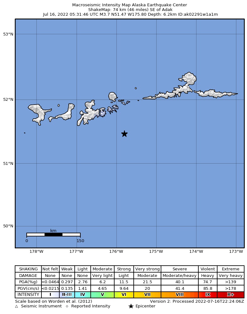
The USGS ShakeMap: shaking estimated from seismic stations and the quake’s size, on the Modified Mercalli intensity scale.
- Strongest estimated
- II, weak shaking
- Peak ground acceleration
- 0.1% of gravity
- Peak ground velocity
- -3.8 cm/s
- Map
- Automatic
Did you feel it?
No one has reported feeling this quake to the USGS.
How well it is located
Reviewed by a seismologist.
- Location uncertainty
- About 5.2 km horizontally, 7.3 km in depth
- Magnitude uncertainty
- ±0.11
- Depth from
- From location
- Station coverage gap
- 184°, poorly surrounded by stations
- Stations used
- 76
Nearby
Within 100 km, magnitude 1.5 and up: at least 199 in the 60 days after this one and 145 in the 30 days before it.
After
- 1.785 km ESE of Adak, Alaska · 1536 days ago · 35 km deep · 14 km away
- 1.980 km SE of Adak, Alaska · 1536 days ago · 22 km deep · 14 km away
- 1.747 km W of Atka, Alaska · 1536 days ago · 13 km deep · 82 km away
- 1.747 km W of Atka, Alaska · 1536 days ago · 13 km deep · 85 km away
- 3.029 km SSW of Atka, Alaska · 1536 days ago · 170 km deep · 95 km away
- 2.478 km WNW of Atka, Alaska · 1536 days ago · 206 km deep · 88 km away
- 3.144 km S of Adak, Alaska · 1535 days ago · 35 km deep · 63 km away
- 1.743 km W of Atka, Alaska · 1535 days ago · 25 km deep · 86 km away
- 1.566 km SE of Adak, Alaska · 1535 days ago · 45 km deep · 32 km away
- 2.873 km NE of Adak, Alaska · 1535 days ago · 210 km deep · 87 km away
- 1.686 km ESE of Adak, Alaska · 1535 days ago · 10 km deep · 13 km away
- 1.642 km W of Atka, Alaska · 1535 days ago · 26 km deep · 84 km away
- 1.945 km W of Atka, Alaska · 1534 days ago · 13 km deep · 84 km away
- 1.661 km SE of Adak, Alaska · 1534 days ago · 22 km deep · 35 km away
- 2.950 km SE of Adak, Alaska · 1534 days ago · 37 km deep · 34 km away
- 1.859 km W of Atka, Alaska · 1534 days ago · 129 km deep · 80 km away
- 3.470 km SW of Atka, Alaska · 1534 days ago · 35 km deep · 53 km away
- 1.5Andreanof Islands, Aleutian Islands, Alaska · 1534 days ago · 13 km deep · 63 km away
- 1.843 km W of Atka, Alaska · 1533 days ago · 25 km deep · 83 km away
- 1.785 km SSW of Atka, Alaska · 1532 days ago · 12 km deep · 53 km away
- 2.547 km W of Atka, Alaska · 1531 days ago · 17 km deep · 80 km away
- 3.764 km ESE of Adak, Alaska · 1531 days ago · 35 km deep · 14 km away
- 3.329 km SSE of Adak, Alaska · 1531 days ago · 52 km deep · 55 km away
- 2.653 km E of Adak, Alaska · 1531 days ago · 211 km deep · 45 km away
- 1.764 km SE of Adak, Alaska · 1531 days ago · 26 km deep · 26 km away
- 1.676 km SE of Adak, Alaska · 1531 days ago · 22 km deep · 22 km away
- 1.972 km WSW of Atka, Alaska · 1531 days ago · 146 km deep · 56 km away
- 1.848 km W of Atka, Alaska · 1531 days ago · 82 km deep · 83 km away
- 1.631 km W of Atka, Alaska · 1531 days ago · 83 km deep · 98 km away
- 1.664 km ENE of Adak, Alaska · 1531 days ago · 101 km deep · 47 km away
- 1.546 km SW of Atka, Alaska · 1530 days ago · 59 km deep · 76 km away
- 1.683 km E of Adak, Alaska · 1530 days ago · 137 km deep · 50 km away
- 1.9Andreanof Islands, Aleutian Islands, Alaska · 1530 days ago · 224 km deep · 55 km away
- 1.928 km ENE of Adak, Alaska · 1530 days ago · 211 km deep · 61 km away
- 2.0Andreanof Islands, Aleutian Islands, Alaska · 1529 days ago · 65 km deep · 46 km away
- 2.753 km E of Adak, Alaska · 1529 days ago · 78 km deep · 39 km away
- 1.673 km SSW of Atka, Alaska · 1529 days ago · 26 km deep · 59 km away
- 1.648 km W of Atka, Alaska · 1529 days ago · 24 km deep · 82 km away
- 1.546 km W of Atka, Alaska · 1529 days ago · 13 km deep · 80 km away
- 2.945 km SSE of Adak, Alaska · 1529 days ago · 36 km deep · 51 km away
- 1.7Andreanof Islands, Aleutian Islands, Alaska · 1528 days ago · 30 km deep · 17 km away
- 3.061 km SSW of Atka, Alaska · 1528 days ago · 65 km deep · 74 km away
- 2.857 km NE of Adak, Alaska · 1528 days ago · 189 km deep · 75 km away
- 2.064 km SE of Adak, Alaska · 1527 days ago · 26 km deep · 27 km away
- 2.853 km SE of Adak, Alaska · 1527 days ago · 45 km deep · 38 km away
- 1.748 km E of Adak, Alaska · 1527 days ago · 127 km deep · 44 km away
- 1.738 km SE of Adak, Alaska · 1526 days ago · 56 km deep · 40 km away
- 2.043 km ENE of Adak, Alaska · 1526 days ago · 123 km deep · 50 km away
- 1.568 km SSW of Atka, Alaska · 1525 days ago · 18 km deep · 69 km away
- 2.854 km WSW of Atka, Alaska · 1525 days ago · 88 km deep · 65 km away
- 1.767 km SSW of Atka, Alaska · 1525 days ago · 19 km deep · 63 km away
- 3.427 km SSE of Adak, Alaska · 1525 days ago · 72 km deep · 63 km away
- 2.153 km E of Adak, Alaska · 1525 days ago · 120 km deep · 31 km away
- 2.793 km ESE of Adak, Alaska · 1524 days ago · 49 km deep · 19 km away
- 2.770 km SE of Adak, Alaska · 1524 days ago · 34 km deep · 14 km away
- 1.662 km SW of Atka, Alaska · 1524 days ago · 44 km deep · 57 km away
- 3.485 km WSW of Atka, Alaska · 1522 days ago · 69 km deep · 38 km away
- 1.662 km SSW of Atka, Alaska · 1521 days ago · 7 km deep · 73 km away
- 3.548 km SSE of Adak, Alaska · 1521 days ago · 35 km deep · 48 km away
- 1.680 km ESE of Adak, Alaska · 1521 days ago · 22 km deep · 10 km away
The first 60 of at least 199.
Before
- 3.067 km ENE of Adak, Alaska · 1536 days ago · 140 km deep · 57 km away
- 2.253 km E of Adak, Alaska · 1536 days ago · 73 km deep · 36 km away
- 1.641 km W of Atka, Alaska · 1536 days ago · 25 km deep · 87 km away
- 3.147 km W of Atka, Alaska · 1536 days ago · 10 km deep · 81 km away
- 1.829 km ENE of Adak, Alaska · 1537 days ago · 118 km deep · 62 km away
- 2.047 km ENE of Adak, Alaska · 1537 days ago · 99 km deep · 55 km away
- 1.6Andreanof Islands, Aleutian Islands, Alaska · 1537 days ago · 39 km deep · 83 km away
- 1.816 km SSE of Adak, Alaska · 1537 days ago · 81 km deep · 63 km away
- 1.670 km ESE of Adak, Alaska · 1537 days ago · 32 km deep · 8 km away
- 1.6Andreanof Islands, Aleutian Islands, Alaska · 1537 days ago · 18 km deep · 63 km away
- 1.943 km SSE of Adak, Alaska · 1537 days ago · 33 km deep · 53 km away
- 3.0Andreanof Islands, Aleutian Islands, Alaska · 1537 days ago · 38 km deep · 53 km away
- 3.928 km SE of Adak, Alaska · 1537 days ago · 58 km deep · 54 km away
- 1.643 km S of Adak, Alaska · 1537 days ago · 30 km deep · 67 km away
- 2.059 km SSE of Adak, Alaska · 1537 days ago · 140 km deep · 60 km away
- 3.167 km ESE of Adak, Alaska · 1538 days ago · 35 km deep · 13 km away
- 2.055 km WSW of Atka, Alaska · 1538 days ago · 77 km deep · 65 km away
- 1.963 km ENE of Adak, Alaska · 1538 days ago · 151 km deep · 56 km away
- 1.654 km ESE of Adak, Alaska · 1539 days ago · 120 km deep · 25 km away
- 1.770 km E of Adak, Alaska · 1539 days ago · 67 km deep · 23 km away
Earthquakes todayAlaska earthquakesLive radar here
Sources
From the USGS Earthquake Hazards Program and its partner networks, event us6000i340 (also filed as ak02291w1a1m). Read Tue, Sep 29, 2026, 12:01 PM UTC.