M3.8 earthquake 183 km WNW of Adak, Alaska
A magnitude 3.8 earthquake struck 183 km WNW of Adak, Alaska on Tue, Mar 15, 2022, 3:36 AM HADT (12:36 UTC), 221 km (137 mi) below the surface.
A larger quake followed: M3.9 184 km WNW of Adak, Alaska. This one was a foreshock.
Map
Where this earthquake was located, with the others nearby. Select one for its page.
The earthquake
- Magnitude
- 3.8 (mb), minor
- Local time
- UTC
- 2022-03-15 12:36:57 UTC
- Depth
- 220.8 km (137.2 mi), intermediate-depth
- Epicenter
- 52.271° N, 179.233° W
- Region
- Alaska
- Strongest shaking
- II, weak shaking
- Tsunami flag
- No
- Status
- Reviewed by a seismologist
Shaking
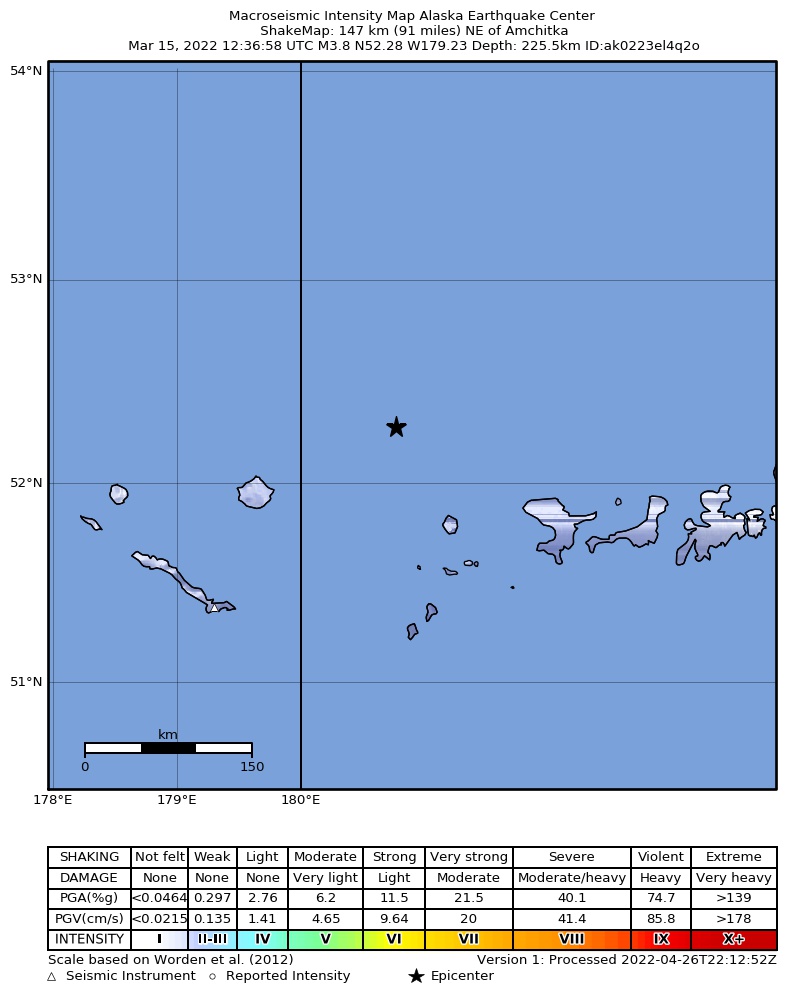
The USGS ShakeMap: shaking estimated from seismic stations and the quake’s size, on the Modified Mercalli intensity scale.
- Strongest estimated
- II, weak shaking
- Peak ground acceleration
- 0.0% of gravity
- Peak ground velocity
- -5.2 cm/s
- Map
- Automatic
Did you feel it?
No one has reported feeling this quake to the USGS.
How well it is located
Reviewed by a seismologist.
- Location uncertainty
- About 9.5 km horizontally, 6.7 km in depth
- Magnitude uncertainty
- ±0.07
- Depth from
- From location
- Station coverage gap
- 125°
- Stations used
- 110
Nearby
Within 100 km, magnitude 1.5 and up: 62 in the 60 days after this one and 15 in the 30 days before it.
After
- 1.5126 km W of Adak, Alaska · 1659 days ago · 13 km deep · 84 km away
- 2.5243 km W of Adak, Alaska · 1659 days ago · 166 km deep · 67 km away
- 2.3251 km W of Adak, Alaska · 1658 days ago · 158 km deep · 80 km away
- 1.6128 km WSW of Adak, Alaska · 1657 days ago · 5 km deep · 89 km away
- 1.8152 km WSW of Adak, Alaska · 1655 days ago · 63 km deep · 91 km away
- 3.9184 km WNW of Adak, Alaska · 1655 days ago · 178 km deep · 3 km away
- 2.1162 km WSW of Adak, Alaska · 1650 days ago · 143 km deep · 85 km away
- 3.2258 km W of Adak, Alaska · 1649 days ago · 194 km deep · 85 km away
- 1.7128 km W of Adak, Alaska · 1649 days ago · 13 km deep · 80 km away
- 2.3134 km W of Adak, Alaska · 1647 days ago · 95 km deep · 68 km away
- 1.8145 km WSW of Adak, Alaska · 1645 days ago · 6 km deep · 97 km away
- 2.1103 km W of Adak, Alaska · 1645 days ago · 133 km deep · 99 km away
- 2.7186 km W of Adak, Alaska · 1643 days ago · 83 km deep · 77 km away
- 2.1224 km W of Adak, Alaska · 1643 days ago · 76 km deep · 79 km away
- 2.5170 km W of Adak, Alaska · 1643 days ago · 13 km deep · 60 km away
- 2.0165 km W of Adak, Alaska · 1641 days ago · 79 km deep · 49 km away
- 2.1256 km W of Adak, Alaska · 1638 days ago · 85 km deep · 97 km away
- 2.2250 km W of Adak, Alaska · 1637 days ago · 154 km deep · 75 km away
- 1.9182 km W of Adak, Alaska · 1637 days ago · 109 km deep · 42 km away
- 2.8243 km W of Adak, Alaska · 1637 days ago · 199 km deep · 70 km away
- 1.8256 km W of Adak, Alaska · 1636 days ago · 14 km deep · 89 km away
- 1.7159 km WSW of Adak, Alaska · 1636 days ago · 13 km deep · 87 km away
- 2.7169 km W of Adak, Alaska · 1635 days ago · 100 km deep · 58 km away
- 1.6145 km WSW of Adak, Alaska · 1635 days ago · 15 km deep · 93 km away
- 2.9246 km W of Adak, Alaska · 1634 days ago · 181 km deep · 74 km away
- 2.9229 km WSW of Adak, Alaska · 1632 days ago · 71 km deep · 96 km away
- 2.1174 km W of Adak, Alaska · 1631 days ago · 97 km deep · 55 km away
- 2.3248 km W of Adak, Alaska · 1631 days ago · 155 km deep · 71 km away
- 2.0153 km W of Adak, Alaska · 1631 days ago · 77 km deep · 75 km away
- 3.094 km W of Adak, Alaska · 1628 days ago · 115 km deep · 98 km away
- 2.4152 km WSW of Adak, Alaska · 1624 days ago · 71 km deep · 82 km away
- 2.4181 km W of Adak, Alaska · 1624 days ago · 86 km deep · 65 km away
- 3.0132 km W of Adak, Alaska · 1621 days ago · 151 km deep · 53 km away
- 2.8203 km W of Adak, Alaska · 1620 days ago · 133 km deep · 52 km away
- 1.8132 km WSW of Adak, Alaska · 1616 days ago · 13 km deep · 86 km away
- 2.6178 km WSW of Adak, Alaska · 1616 days ago · 74 km deep · 78 km away
- 3.8192 km WNW of Adak, Alaska · 1615 days ago · 215 km deep · 10 km away
- 1.7126 km WSW of Adak, Alaska · 1615 days ago · 12 km deep · 91 km away
- 1.6134 km W of Adak, Alaska · 1614 days ago · 15 km deep · 73 km away
- 2.2180 km WSW of Adak, Alaska · 1613 days ago · 75 km deep · 78 km away
- 2.1106 km W of Adak, Alaska · 1613 days ago · 90 km deep · 88 km away
- 2.7138 km W of Adak, Alaska · 1612 days ago · 124 km deep · 68 km away
- 1.6197 km W of Adak, Alaska · 1612 days ago · 13 km deep · 53 km away
- 1.8159 km W of Adak, Alaska · 1611 days ago · 7 km deep · 54 km away
- 2.7133 km W of Adak, Alaska · 1611 days ago · 229 km deep · 55 km away
- 1.7158 km W of Adak, Alaska · 1611 days ago · 8 km deep · 57 km away
- 1.6157 km W of Adak, Alaska · 1611 days ago · 8 km deep · 57 km away
- 2.5189 km WSW of Adak, Alaska · 1609 days ago · 73 km deep · 81 km away
- 2.9147 km WNW of Adak, Alaska · 1609 days ago · 252 km deep · 36 km away
- 1.8231 km W of Adak, Alaska · 1608 days ago · 73 km deep · 83 km away
- 2.6239 km W of Adak, Alaska · 1606 days ago · 177 km deep · 60 km away
- 1.7127 km WSW of Adak, Alaska · 1606 days ago · 10 km deep · 97 km away
- 3.8249 km W of Adak, Alaska · 1605 days ago · 93 km deep · 85 km away
- 2.4105 km WNW of Adak, Alaska · 1605 days ago · 265 km deep · 79 km away
- 1.6140 km WSW of Adak, Alaska · 1605 days ago · 10 km deep · 100 km away
- 2.9206 km W of Adak, Alaska · 1604 days ago · 105 km deep · 58 km away
- 2.8202 km W of Adak, Alaska · 1604 days ago · 174 km deep · 40 km away
- 2.5208 km W of Adak, Alaska · 1603 days ago · 83 km deep · 75 km away
- 1.8131 km W of Adak, Alaska · 1603 days ago · 11 km deep · 71 km away
- 1.7192 km W of Adak, Alaska · 1601 days ago · 124 km deep · 57 km away
The first 60 of 62.
Before
- 2.0203 km W of Adak, Alaska · 1663 days ago · 121 km deep · 54 km away
- 1.7133 km WSW of Adak, Alaska · 1664 days ago · 71 km deep · 89 km away
- 2.0102 km W of Adak, Alaska · 1664 days ago · 134 km deep · 85 km away
- 2.0221 km W of Adak, Alaska · 1665 days ago · 71 km deep · 83 km away
- 1.7201 km W of Adak, Alaska · 1665 days ago · 13 km deep · 64 km away
- 2.8131 km W of Adak, Alaska · 1666 days ago · 19 km deep · 83 km away
- 2.9250 km W of Adak, Alaska · 1666 days ago · 189 km deep · 81 km away
- 3.2Rat Islands, Aleutian Islands, Alaska · 1666 days ago · 174 km deep · 85 km away
- 1.9172 km WSW of Adak, Alaska · 1672 days ago · 13 km deep · 90 km away
- 1.7131 km WSW of Adak, Alaska · 1676 days ago · 14 km deep · 89 km away
- 1.7133 km W of Adak, Alaska · 1678 days ago · 14 km deep · 78 km away
- 3.1204 km W of Adak, Alaska · 1678 days ago · 100 km deep · 71 km away
- 1.8101 km W of Adak, Alaska · 1684 days ago · 7 km deep · 88 km away
- 2.2Andreanof Islands, Aleutian Islands, Alaska · 1685 days ago · 105 km deep · 50 km away
- 1.9127 km WSW of Adak, Alaska · 1688 days ago · 13 km deep · 87 km away
Earthquakes todayAlaska earthquakesLive radar here
Sources
From the USGS Earthquake Hazards Program and its partner networks, event us6000h5tb (also filed as ak0223el4q2o). Read Wed, Sep 30, 2026, 10:53 PM UTC.