M3.7 earthquake 103 km NE of Adak, Alaska
A magnitude 3.7 earthquake struck 103 km NE of Adak, Alaska on Tue, Mar 15, 2022, 2:57 AM HADT (11:57 UTC), 245 km (152 mi) below the surface.
A larger quake followed: M4.5 62 km NNW of Atka, Alaska. This one was a foreshock.
Map
Where this earthquake was located, with the others nearby. Select one for its page.
The earthquake
- Magnitude
- 3.7 (mb), minor
- Local time
- UTC
- 2022-03-15 11:57:30 UTC
- Depth
- 245.0 km (152.3 mi), intermediate-depth
- Epicenter
- 52.619° N, 175.732° W
- Region
- Alaska
- Strongest shaking
- I, not felt shaking
- Tsunami flag
- No
- Status
- Reviewed by a seismologist
Shaking
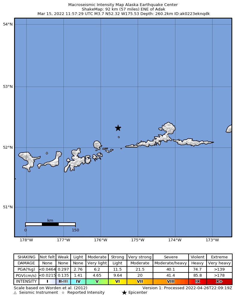
The USGS ShakeMap: shaking estimated from seismic stations and the quake’s size, on the Modified Mercalli intensity scale.
- Strongest estimated
- I, not felt shaking
- Peak ground acceleration
- 0.0% of gravity
- Peak ground velocity
- -5.7 cm/s
- Map
- Automatic
Did you feel it?
No one has reported feeling this quake to the USGS.
How well it is located
Reviewed by a seismologist.
- Location uncertainty
- About 12.1 km horizontally, 8.8 km in depth
- Magnitude uncertainty
- ±0.08
- Depth from
- From location
- Station coverage gap
- 77°
- Stations used
- 100
Nearby
Within 100 km, magnitude 1.5 and up: 56 in the 60 days after this one and 35 in the 30 days before it.
After
- 1.655 km WSW of Atka, Alaska · 1659 days ago · 13 km deep · 83 km away
- 2.270 km ENE of Adak, Alaska · 1659 days ago · 149 km deep · 63 km away
- 2.058 km W of Atka, Alaska · 1659 days ago · 130 km deep · 64 km away
- 2.333 km WNW of Atka, Alaska · 1659 days ago · 130 km deep · 81 km away
- 2.969 km WNW of Atka, Alaska · 1658 days ago · 219 km deep · 46 km away
- 1.765 km E of Adak, Alaska · 1657 days ago · 68 km deep · 88 km away
- 3.9101 km NNW of Atka, Alaska · 1656 days ago · 223 km deep · 76 km away
- 1.530 km E of Adak, Alaska · 1654 days ago · 86 km deep · 84 km away
- 2.072 km WSW of Atka, Alaska · 1654 days ago · 58 km deep · 95 km away
- 2.230 km ESE of Adak, Alaska · 1652 days ago · 73 km deep · 97 km away
- 2.253 km ENE of Adak, Alaska · 1652 days ago · 146 km deep · 59 km away
- 2.578 km E of Adak, Alaska · 1651 days ago · 222 km deep · 86 km away
- 2.944 km NE of Adak, Alaska · 1650 days ago · 204 km deep · 62 km away
- 1.975 km E of Adak, Alaska · 1649 days ago · 64 km deep · 95 km away
- 1.880 km ENE of Adak, Alaska · 1647 days ago · 17 km deep · 61 km away
- 3.834 km NW of Atka, Alaska · 1646 days ago · 186 km deep · 86 km away
- 1.955 km E of Adak, Alaska · 1646 days ago · 66 km deep · 89 km away
- 2.977 km WNW of Atka, Alaska · 1646 days ago · 257 km deep · 37 km away
- 1.882 km ENE of Adak, Alaska · 1645 days ago · 13 km deep · 68 km away
- 1.781 km ENE of Adak, Alaska · 1645 days ago · 13 km deep · 61 km away
- 1.927 km E of Adak, Alaska · 1645 days ago · 73 km deep · 93 km away
- 1.768 km ESE of Adak, Alaska · 1644 days ago · 14 km deep · 97 km away
- 3.3Andreanof Islands, Aleutian Islands, Alaska · 1642 days ago · 245 km deep · 37 km away
- 2.665 km ENE of Adak, Alaska · 1641 days ago · 199 km deep · 62 km away
- 2.747 km ENE of Adak, Alaska · 1638 days ago · 133 km deep · 72 km away
- 1.965 km WSW of Atka, Alaska · 1638 days ago · 65 km deep · 90 km away
- 2.345 km E of Adak, Alaska · 1635 days ago · 79 km deep · 81 km away
- 1.880 km ENE of Adak, Alaska · 1634 days ago · 15 km deep · 62 km away
- 2.337 km ENE of Adak, Alaska · 1634 days ago · 127 km deep · 71 km away
- 2.880 km NE of Adak, Alaska · 1633 days ago · 161 km deep · 28 km away
- 3.6Andreanof Islands, Aleutian Islands, Alaska · 1632 days ago · 82 km deep · 94 km away
- 2.551 km NE of Adak, Alaska · 1632 days ago · 188 km deep · 52 km away
- 2.755 km NNW of Atka, Alaska · 1624 days ago · 171 km deep · 80 km away
- 1.911 km E of Adak, Alaska · 1623 days ago · 85 km deep · 97 km away
- 3.477 km NW of Atka, Alaska · 1623 days ago · 200 km deep · 61 km away
- 2.264 km NE of Adak, Alaska · 1622 days ago · 165 km deep · 39 km away
- 2.783 km NNE of Adak, Alaska · 1619 days ago · 173 km deep · 26 km away
- 2.378 km ENE of Adak, Alaska · 1617 days ago · 155 km deep · 42 km away
- 4.562 km NNW of Atka, Alaska · 1617 days ago · 193 km deep · 82 km away
- 1.673 km ENE of Adak, Alaska · 1617 days ago · 7 km deep · 63 km away
- 3.723 km NNW of Atka, Alaska · 1616 days ago · 102 km deep · 95 km away
- 1.753 km WSW of Atka, Alaska · 1616 days ago · 81 km deep · 96 km away
- 2.757 km ENE of Adak, Alaska · 1614 days ago · 237 km deep · 59 km away
- 2.881 km NNE of Adak, Alaska · 1609 days ago · 225 km deep · 34 km away
- 1.935 km W of Atka, Alaska · 1609 days ago · 7 km deep · 83 km away
- 2.024 km NNW of Atka, Alaska · 1608 days ago · 133 km deep · 96 km away
- 2.371 km ENE of Adak, Alaska · 1607 days ago · 237 km deep · 52 km away
- 2.926 km NNW of Atka, Alaska · 1607 days ago · 232 km deep · 94 km away
- 2.057 km NE of Adak, Alaska · 1606 days ago · 167 km deep · 48 km away
- 2.583 km ENE of Adak, Alaska · 1603 days ago · 152 km deep · 61 km away
- 2.026 km E of Adak, Alaska · 1602 days ago · 180 km deep · 94 km away
- 1.943 km W of Atka, Alaska · 1602 days ago · 5 km deep · 80 km away
- 1.950 km NE of Adak, Alaska · 1601 days ago · 151 km deep · 57 km away
- 1.846 km WSW of Atka, Alaska · 1601 days ago · 139 km deep · 93 km away
- 1.648 km NE of Adak, Alaska · 1601 days ago · 136 km deep · 55 km away
- 1.646 km ENE of Adak, Alaska · 1601 days ago · 139 km deep · 62 km away
Before
- 2.665 km E of Adak, Alaska · 1661 days ago · 187 km deep · 70 km away
- 1.759 km E of Adak, Alaska · 1661 days ago · 71 km deep · 92 km away
- 2.047 km E of Adak, Alaska · 1662 days ago · 123 km deep · 86 km away
- 2.440 km NNW of Atka, Alaska · 1662 days ago · 178 km deep · 89 km away
- 2.150 km NE of Adak, Alaska · 1662 days ago · 146 km deep · 57 km away
- 3.6129 km NW of Atka, Alaska · 1663 days ago · 194 km deep · 37 km away
- 1.880 km ENE of Adak, Alaska · 1664 days ago · 13 km deep · 66 km away
- 2.082 km ENE of Adak, Alaska · 1665 days ago · 13 km deep · 60 km away
- 3.783 km E of Adak, Alaska · 1665 days ago · 73 km deep · 86 km away
- 2.068 km WSW of Atka, Alaska · 1665 days ago · 67 km deep · 88 km away
- 2.153 km NE of Adak, Alaska · 1665 days ago · 147 km deep · 56 km away
- 1.617 km ENE of Adak, Alaska · 1665 days ago · 78 km deep · 89 km away
- 3.086 km NE of Adak, Alaska · 1666 days ago · 170 km deep · 19 km away
- 1.65 km NE of Adak, Alaska · 1668 days ago · 7 km deep · 98 km away
- 1.852 km E of Adak, Alaska · 1668 days ago · 123 km deep · 76 km away
- 1.96 km NE of Adak, Alaska · 1669 days ago · 6 km deep · 97 km away
- 1.566 km E of Adak, Alaska · 1671 days ago · 26 km deep · 95 km away
- 1.7Andreanof Islands, Aleutian Islands, Alaska · 1671 days ago · 74 km deep · 97 km away
- 1.980 km W of Atka, Alaska · 1672 days ago · 115 km deep · 61 km away
- 4.075 km W of Atka, Alaska · 1672 days ago · 147 km deep · 63 km away
Earthquakes todayAlaska earthquakesLive radar here
Sources
From the USGS Earthquake Hazards Program and its partner networks, event us6000h5ta (also filed as ak0223eknqdk). Read Thu, Oct 1, 2026, 12:45 AM UTC.