M3.7 earthquake 6km ESE of Wilkerson, CA
A magnitude 3.7 earthquake struck 6km ESE of Wilkerson, CA on Sun, Feb 14, 2021, 3:57 AM PST (11:57 UTC), 12 km (8 mi) below the surface.
Map
Where this earthquake was located, with the others nearby. Select one for its page.
The earthquake
- Magnitude
- 3.7 (Mw, moment), minor
- Magnitude from
- Northern California Seismic System
- Local time
- UTC
- 2021-02-14 11:57:50 UTC
- Depth
- 12.2 km (7.6 mi), shallow
- Epicenter
- 37.263° N, 118.320° W
- Region
- California
- Felt reports
- 58
- Strongest shaking
- IV, light shaking
- Tsunami flag
- No
- Status
- Reviewed by a seismologist
Magnitude estimates
Different scales measure different things and differ by a few tenths. The USGS marks one as preferred, and it is the one this page uses.
| Mag. | Scale | Computed by | Notes |
|---|---|---|---|
| 3.69 | Mw, moment | Northern California Seismic System | Preferred · Final · 3 stations |
| 3.14 | ML, local (Richter) | Southern California Seismic Network | Preliminary · ±0.484 · 24 stations |
| 3.7 | Mwr, regional moment | USGS National Earthquake Information Center | Reviewed · 3 stations |
| 4.0 | ML, local (Richter) | Nevada Seismological Laboratory | Reviewed · ±0.46 · 11 stations |
Shaking
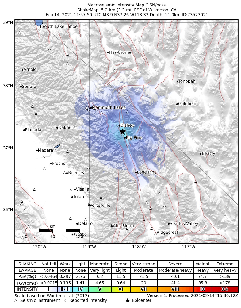
The USGS ShakeMap: shaking estimated from seismic stations and the quake’s size, on the Modified Mercalli intensity scale.
- Strongest estimated
- IV, light shaking
- Peak ground acceleration
- 2.3% of gravity
- Peak ground velocity
- -0.4 cm/s
- Map
- Automatic
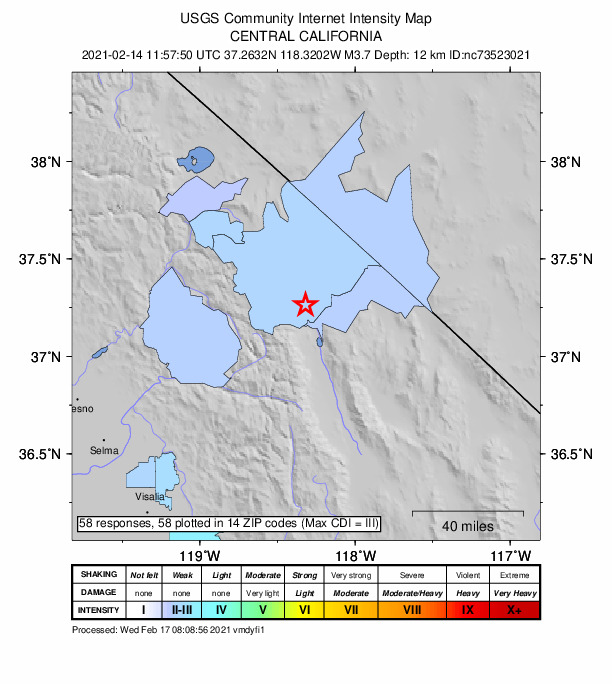
Did you feel it?
58 people reported to the USGS what they felt; the strongest reported shaking was III, weak shaking.
Fault motion and ground failure
How the rock slipped, from the moment tensor, and the USGS estimate of landslides and liquefaction.
- Moment magnitude
- 3.7 Mw
How well it is located
Reviewed by a seismologist.
- Location uncertainty
- About 0.3 km horizontally, 0.6 km in depth
- Depth from
- From location
- Station coverage gap
- 119°
- Stations used
- 45
Nearest places
Distance and direction from each place to the epicenter, with its forecast.
Nearby
Within 100 km, magnitude 1.5 and up: 161 in the 60 days after this one and 164 in the 30 days before it.
After
- 2.315km SE of Lone Pine, CA · 2056 days ago · 10 km deep · 93 km away
- 2.515km WSW of Toms Place, CA · 2055 days ago · 5 km deep · 53 km away · felt by 1
- 1.8Central California · 2055 days ago · 0 km deep · 82 km away
- 1.931 km SSW of Mina, Nevada · 2055 days ago · 2 km deep · 95 km away
- 1.631 km SSW of Mina, Nevada · 2055 days ago · 3 km deep · 96 km away
- 1.97km E of Wilkerson, CA · 2054 days ago · 13 km deep · 1 km away
- 1.629 km S of Mina, Nevada · 2054 days ago · 4 km deep · 98 km away
- 1.559 km S of Goldfield, Nevada · 2054 days ago · 0 km deep · 88 km away
- 1.716km SE of Lone Pine, CA · 2053 days ago · 9 km deep · 94 km away
- 3.414km NE of Big Pine, CA · 2052 days ago · 9 km deep · 14 km away · felt by 9
- 2.415km ENE of Big Pine, CA · 2052 days ago · 9 km deep · 16 km away · felt by 2
- 1.536 km SW of Mina, Nevada · 2052 days ago · 9 km deep · 98 km away
- 1.834km E of Lee Vining, CA · 2051 days ago · 4 km deep · 81 km away
- 1.511 km NW of Benton, California · 2051 days ago · 9 km deep · 74 km away
- 1.66km ESE of Lone Pine, CA · 2050 days ago · 6 km deep · 83 km away
- 1.630 km SSE of Mina, Nevada · 2050 days ago · 7 km deep · 99 km away
- 1.6California-Nevada border region · 2049 days ago · 11 km deep · 100 km away
- 2.324km NNE of Squaw Valley, CA · 2048 days ago · 43 km deep · 81 km away · felt by 1
- 2.033 km SSW of Mina, Nevada · 2048 days ago · 6 km deep · 93 km away
- 2.37km ESE of Lone Pine, CA · 2048 days ago · 7 km deep · 83 km away
- 1.917km WSW of Toms Place, CA · 2048 days ago · 6 km deep · 53 km away
- 1.556 km SSW of Goldfield, Nevada · 2048 days ago · 9 km deep · 74 km away
- 1.727km SE of Bodie, CA · 2047 days ago · 6 km deep · 96 km away
- 1.541km NNE of Toms Place, CA · 2047 days ago · 5 km deep · 76 km away
- 2.540km NNE of Toms Place, CA · 2047 days ago · 8 km deep · 74 km away
- 2.87km ESE of Lone Pine, CA · 2047 days ago · 7 km deep · 83 km away · felt by 2
- 2.136 km NNE of Benton, California · 2047 days ago · 10 km deep · 98 km away
- 1.636 km N of Benton, California · 2046 days ago · 12 km deep · 98 km away
- 1.936 km NNE of Benton, California · 2046 days ago · 8 km deep · 98 km away
- 2.914km S of Mammoth Lakes, CA · 2045 days ago · 2 km deep · 66 km away
- 1.616km SE of Lone Pine, CA · 2045 days ago · 9 km deep · 93 km away
- 1.712km ESE of Mammoth Lakes, CA · 2044 days ago · 0 km deep · 60 km away
- 2.518km ESE of Lone Pine, CA · 2044 days ago · 9 km deep · 93 km away · felt by 1
- 1.531km SE of Bodie, CA · 2044 days ago · 0 km deep · 94 km away
- 2.818km SSE of Shaver Lake, CA · 2043 days ago · 33 km deep · 92 km away · felt by 32
- 1.718km SE of Lone Pine, CA · 2043 days ago · 8 km deep · 93 km away
- 2.36km ESE of Lone Pine, CA · 2043 days ago · 7 km deep · 82 km away
- 2.27km ESE of Lone Pine, CA · 2043 days ago · 7 km deep · 83 km away
- 1.75km N of Round Valley, CA · 2043 days ago · 13 km deep · 34 km away
- 3.57km ESE of Lone Pine, CA · 2043 days ago · 8 km deep · 84 km away · felt by 34
- 1.940km NNE of Toms Place, CA · 2043 days ago · 3 km deep · 75 km away
- 1.640km NNE of Toms Place, CA · 2042 days ago · 2 km deep · 75 km away
- 1.526km E of Lee Vining, CA · 2042 days ago · 1 km deep · 93 km away
- 1.99km E of Mammoth Lakes, CA · 2042 days ago · 2 km deep · 65 km away
- 2.540km NNE of Toms Place, CA · 2042 days ago · 6 km deep · 75 km away
- 2.17 km SE of Big Pine, California · 2042 days ago · 0 km deep · 18 km away
- 1.915km SE of Lone Pine, CA · 2042 days ago · 8 km deep · 93 km away
- 1.56km ESE of Lone Pine, CA · 2041 days ago · 5 km deep · 82 km away
- 1.935 km NNE of Benton, California · 2040 days ago · 2 km deep · 92 km away
- 1.634 km SSW of Mina, Nevada · 2040 days ago · 3 km deep · 94 km away
- 1.86km ESE of Lone Pine, CA · 2040 days ago · 7 km deep · 83 km away
- 1.717km SSE of Lone Pine, CA · 2040 days ago · 6 km deep · 95 km away
- 2.241km NNE of Toms Place, CA · 2040 days ago · 4 km deep · 76 km away
- 2.128 km S of Mina, Nevada · 2040 days ago · 3 km deep · 100 km away
- 1.819km E of Big Pine, CA · 2040 days ago · 1 km deep · 25 km away
- 2.06km ESE of Lone Pine, CA · 2039 days ago · 7 km deep · 82 km away
- 1.918km ESE of Lone Pine, CA · 2039 days ago · 9 km deep · 93 km away
- 1.87km ESE of Lone Pine, CA · 2039 days ago · 7 km deep · 83 km away
- 2.235 km N of Benton, California · 2039 days ago · 4 km deep · 97 km away
- 2.032 km N of Dyer, Nevada · 2038 days ago · 7 km deep · 79 km away
The first 60 of 161.
Before
- 1.613km WSW of Wilkerson, CA · 2057 days ago · 16 km deep · 19 km away
- 1.959 km WNW of Beatty, Nevada · 2057 days ago · 8 km deep · 86 km away
- 2.119km SSE of Lone Pine, CA · 2057 days ago · 8 km deep · 96 km away
- 1.632 km S of Mina, Nevada · 2057 days ago · 7 km deep · 94 km away
- 2.313km W of Toms Place, CA · 2058 days ago · 7 km deep · 54 km away
- 1.641km NNE of Toms Place, CA · 2059 days ago · 5 km deep · 76 km away
- 1.98km E of Mammoth Lakes, CA · 2059 days ago · 3 km deep · 65 km away
- 1.717km WSW of Round Valley, CA · 2061 days ago · 10 km deep · 43 km away
- 1.86km SW of Round Valley, CA · 2061 days ago · 13 km deep · 31 km away
- 1.95km SW of Round Valley, CA · 2061 days ago · 12 km deep · 31 km away
- 1.630 km S of Mina, Nevada · 2061 days ago · 14 km deep · 98 km away
- 1.913 km NW of Benton, California · 2062 days ago · 7 km deep · 75 km away
- 1.640km NNE of Toms Place, CA · 2062 days ago · 1 km deep · 75 km away
- 2.223km S of Mammoth Lakes, CA · 2062 days ago · 3 km deep · 64 km away
- 1.612 km NW of Benton, California · 2062 days ago · 3 km deep · 75 km away
- 2.240km NNE of Toms Place, CA · 2062 days ago · 6 km deep · 74 km away
- 3.830 km SSE of Mina, Nevada · 2063 days ago · 10 km deep · 99 km away · felt by 1
- 2.040km NNE of Toms Place, CA · 2063 days ago · 1 km deep · 75 km away
- 2.85km NE of Round Valley, CA · 2063 days ago · 13 km deep · 29 km away
- 2.136 km N of Benton, California · 2063 days ago · 5 km deep · 98 km away
Earthquakes todayCalifornia earthquakesLive radar here
Sources
From the USGS Earthquake Hazards Program and its partner networks, event nc73523021 (also filed as ci39551831, nn00800357, us6000dhlb). Read Sat, Oct 3, 2026, 4:00 AM UTC.