M3.3 earthquake 53 km NW of Toyah, Texas
A magnitude 3.3 earthquake struck 53 km NW of Toyah, Texas on Mon, Sep 6, 2021, 9:52 AM CDT (14:52 UTC), 7 km (4 mi) below the surface.
A larger quake followed: M4.3 55 km S of Whites City, New Mexico. This one was a foreshock.
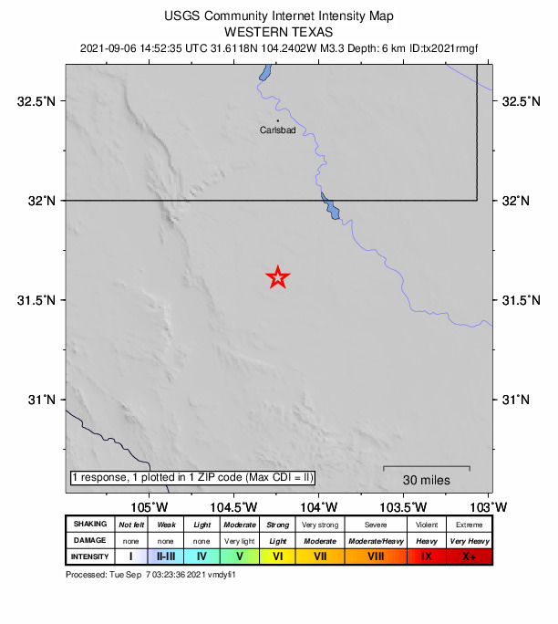
Map
Where this earthquake was located, with the others nearby. Select one for its page.
The earthquake
- Magnitude
- 3.3 (ml), minor
- Local time
- UTC
- 2021-09-06 14:52:35 UTC
- Depth
- 6.5 km (4.1 mi), shallow
- Epicenter
- 31.612° N, 104.240° W
- Region
- Texas
- Felt reports
- 1
- Tsunami flag
- No
- Status
- Reviewed by a seismologist
Did you feel it?
1 person reported to the USGS what they felt; the strongest reported shaking was II, weak shaking.
Fault motion and ground failure
How the rock slipped, from the moment tensor, and the USGS estimate of landslides and liquefaction.
- Faulting
- Normal
- Moment magnitude
- 3.2 Mwr
- Nodal plane 1
- Strike 84°, dip 60°, rake -93°
- Nodal plane 2
- Strike 270°, dip 30°, rake -85°
How well it is located
Reviewed by a seismologist.
- Location uncertainty
- About 0.9 km horizontally, 1.6 km in depth
- Magnitude uncertainty
- ±0.20
- Station coverage gap
- 67°
- Stations used
- 25
Nearest places
Distance and direction from each place to the epicenter, with its forecast.
Nearby
Within 100 km, magnitude 1.5 and up: at least 200 in the 60 days after this one and at least 200 in the 30 days before it.
After
- 2.040 km W of Mentone, Texas · 1846 days ago · 8 km deep · 23 km away
- 1.856 km S of Whites City, New Mexico · 1846 days ago · 7 km deep · 14 km away
- 1.816 km SSE of Lindsay, Texas · 1846 days ago · 5 km deep · 84 km away
- 1.660 km S of Whites City, New Mexico · 1846 days ago · 5 km deep · 8 km away
- 2.156 km S of Whites City, New Mexico · 1845 days ago · 6 km deep · 14 km away
- 3.156 km S of Whites City, New Mexico · 1845 days ago · 6 km deep · 14 km away
- 1.956 km S of Whites City, New Mexico · 1845 days ago · 6 km deep · 14 km away
- 1.956 km S of Whites City, New Mexico · 1845 days ago · 7 km deep · 14 km away
- 1.756 km S of Whites City, New Mexico · 1845 days ago · 7 km deep · 14 km away
- 1.652 km SSW of Whites City, New Mexico · 1845 days ago · 6 km deep · 30 km away
- 2.857 km S of Whites City, New Mexico · 1845 days ago · 6 km deep · 18 km away
- 2.057 km S of Whites City, New Mexico · 1845 days ago · 6 km deep · 18 km away
- 2.556 km S of Whites City, New Mexico · 1845 days ago · 6 km deep · 14 km away
- 2.258 km S of Whites City, New Mexico · 1845 days ago · 7 km deep · 17 km away
- 2.453 km NW of Toyah, Texas · 1844 days ago · 6 km deep · 1 km away
- 1.854 km NW of Toyah, Texas · 1844 days ago · 7 km deep · 1 km away
- 1.750 km NW of Toyah, Texas · 1844 days ago · 6 km deep · 7 km away
- 1.857 km S of Whites City, New Mexico · 1844 days ago · 7 km deep · 17 km away
- 4.355 km S of Whites City, New Mexico · 1844 days ago · 6 km deep · 15 km away · felt by 4
- 2.356 km S of Whites City, New Mexico · 1844 days ago · 7 km deep · 14 km away
- 2.054 km S of Whites City, New Mexico · 1844 days ago · 6 km deep · 15 km away
- 1.656 km S of Whites City, New Mexico · 1844 days ago · 6 km deep · 14 km away
- 2.457 km S of Whites City, New Mexico · 1844 days ago · 6 km deep · 18 km away
- 2.156 km S of Whites City, New Mexico · 1844 days ago · 7 km deep · 14 km away
- 1.853 km S of Whites City, New Mexico · 1844 days ago · 7 km deep · 12 km away
- 1.957 km S of Whites City, New Mexico · 1844 days ago · 6 km deep · 18 km away
- 2.456 km S of Whites City, New Mexico · 1844 days ago · 7 km deep · 15 km away
- 1.955 km S of Whites City, New Mexico · 1844 days ago · 7 km deep · 15 km away
- 2.056 km S of Whites City, New Mexico · 1844 days ago · 8 km deep · 14 km away
- 1.656 km S of Whites City, New Mexico · 1844 days ago · 6 km deep · 13 km away
- 2.156 km S of Whites City, New Mexico · 1844 days ago · 7 km deep · 14 km away
- 2.355 km S of Whites City, New Mexico · 1844 days ago · 6 km deep · 14 km away
- 1.6western Texas · 1844 days ago · 10 km deep · 89 km away
- 1.844 km NW of Toyah, Texas · 1843 days ago · 7 km deep · 14 km away
- 2.725 km SW of Jal, New Mexico · 1843 days ago · 8 km deep · 90 km away
- 1.725 km SW of Jal, New Mexico · 1843 days ago · 8 km deep · 90 km away
- 2.257 km S of Whites City, New Mexico · 1843 days ago · 6 km deep · 9 km away
- 1.844 km NW of Toyah, Texas · 1843 days ago · 7 km deep · 12 km away
- 2.156 km S of Whites City, New Mexico · 1843 days ago · 6 km deep · 14 km away
- 2.153 km NW of Toyah, Texas · 1843 days ago · 6 km deep · 0 km away
- 2.355 km S of Whites City, New Mexico · 1843 days ago · 7 km deep · 17 km away
- 2.151 km NW of Toyah, Texas · 1843 days ago · 7 km deep · 3 km away
- 2.356 km S of Whites City, New Mexico · 1843 days ago · 7 km deep · 16 km away
- 1.60 km NE of Lindsay, Texas · 1843 days ago · 2 km deep · 72 km away
- 3.155 km S of Whites City, New Mexico · 1843 days ago · 7 km deep · 16 km away
- 2.322 km SE of Malaga, New Mexico · 1843 days ago · 8 km deep · 62 km away
- 2.144 km NW of Toyah, Texas · 1843 days ago · 7 km deep · 13 km away
- 2.553 km NW of Toyah, Texas · 1842 days ago · 6 km deep · 0 km away
- 2.057 km SSW of Whites City, New Mexico · 1842 days ago · 9 km deep · 26 km away
- 2.656 km S of Whites City, New Mexico · 1842 days ago · 6 km deep · 24 km away
- 2.546 km NW of Toyah, Texas · 1842 days ago · 8 km deep · 7 km away
- 2.157 km S of Whites City, New Mexico · 1842 days ago · 6 km deep · 18 km away
- 2.656 km S of Whites City, New Mexico · 1842 days ago · 7 km deep · 15 km away
- 2.055 km S of Whites City, New Mexico · 1841 days ago · 7 km deep · 16 km away
- 2.754 km S of Whites City, New Mexico · 1841 days ago · 7 km deep · 16 km away
- 1.955 km S of Whites City, New Mexico · 1841 days ago · 7 km deep · 15 km away
- 2.156 km S of Whites City, New Mexico · 1841 days ago · 7 km deep · 15 km away
- 2.454 km NW of Toyah, Texas · 1841 days ago · 6 km deep · 5 km away
- 2.256 km S of Whites City, New Mexico · 1841 days ago · 6 km deep · 24 km away
- 2.357 km S of Whites City, New Mexico · 1841 days ago · 6 km deep · 15 km away
The first 60 of at least 200.
Before
- 2.240 km W of Mentone, Texas · 1847 days ago · 8 km deep · 23 km away
- 2.257 km NW of Toyah, Texas · 1847 days ago · 7 km deep · 6 km away
- 2.155 km S of Whites City, New Mexico · 1847 days ago · 6 km deep · 14 km away
- 3.456 km S of Whites City, New Mexico · 1847 days ago · 6 km deep · 14 km away
- 2.856 km S of Whites City, New Mexico · 1847 days ago · 6 km deep · 14 km away
- 2.655 km S of Whites City, New Mexico · 1847 days ago · 7 km deep · 14 km away
- 2.042 km NW of Toyah, Texas · 1847 days ago · 7 km deep · 11 km away
- 1.852 km SSW of Whites City, New Mexico · 1847 days ago · 7 km deep · 30 km away
- 2.239 km W of Mentone, Texas · 1847 days ago · 8 km deep · 24 km away
- 2.254 km S of Whites City, New Mexico · 1847 days ago · 6 km deep · 17 km away
- 2.340 km W of Mentone, Texas · 1847 days ago · 8 km deep · 23 km away
- 1.650 km S of Whites City, New Mexico · 1847 days ago · 8 km deep · 15 km away
- 2.257 km S of Whites City, New Mexico · 1847 days ago · 7 km deep · 9 km away
- 1.855 km S of Whites City, New Mexico · 1847 days ago · 7 km deep · 17 km away
- 2.755 km S of Whites City, New Mexico · 1847 days ago · 6 km deep · 17 km away
- 2.255 km S of Whites City, New Mexico · 1847 days ago · 6 km deep · 17 km away
- 1.928 km NW of Toyah, Texas · 1847 days ago · 8 km deep · 26 km away
- 1.855 km NW of Toyah, Texas · 1848 days ago · 7 km deep · 4 km away
- 2.2western Texas · 1848 days ago · 6 km deep · 4 km away
- 2.555 km S of Whites City, New Mexico · 1848 days ago · 6 km deep · 14 km away
Earthquakes todayTexas earthquakesLive radar here
Sources
From the USGS Earthquake Hazards Program and its partner networks, event tx2021rmgf (also filed as us7000f8kr). Read Sun, Sep 27, 2026, 12:34 AM UTC.