M2.9 earthquake 19 km SW of Salcha, Alaska
A magnitude 2.9 earthquake struck 19 km SW of Salcha, Alaska on Thu, Feb 18, 2021, 4:12 AM AKST (13:12 UTC), 13 km (8 mi) below the surface.
Map
Where this earthquake was located, with the others nearby. Select one for its page.
The earthquake
- Magnitude
- 2.9 (ml), micro
- Local time
- UTC
- 2021-02-18 13:12:49 UTC
- Depth
- 12.9 km (8.0 mi), shallow
- Epicenter
- 64.425° N, 147.245° W
- Region
- Alaska
- Felt reports
- 1
- Tsunami flag
- No
- Status
- Reviewed by a seismologist
Did you feel it?
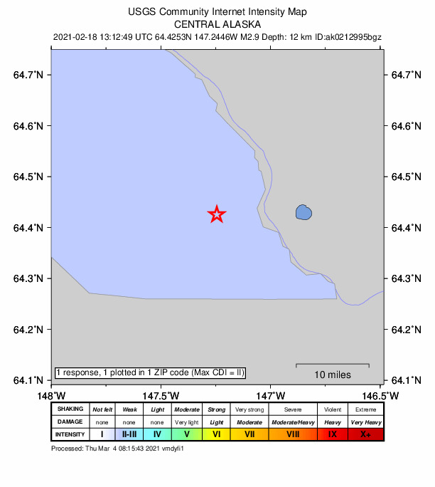
1 person reported to the USGS what they felt; the strongest reported shaking was II, weak shaking.
How well it is located
Reviewed by a seismologist.
- Stations used
- 94
Nearest places
Distance and direction from each place to the epicenter, with its forecast.
Nearby
Within 100 km, magnitude 1.5 and up: 32 in the 60 days after this one and 28 in the 30 days before it.
After
- 1.719 km E of Ferry, Alaska · 2046 days ago · 3 km deep · 85 km away
- 1.511 km E of Fox, Alaska · 2045 days ago · 0 km deep · 62 km away
- 1.614 km S of Ester, Alaska · 2042 days ago · 17 km deep · 50 km away
- 1.819 km NNE of Four Mile Road, Alaska · 2042 days ago · 21 km deep · 92 km away
- 2.912 km N of Pleasant Valley, Alaska · 2038 days ago · 12 km deep · 66 km away · felt by 3
- 1.520 km SW of Harding-Birch Lakes, Alaska · 2036 days ago · 0 km deep · 24 km away
- 1.720 km NE of Healy, Alaska · 2034 days ago · 4 km deep · 85 km away
- 1.89 km SSE of Pleasant Valley, Alaska · 2032 days ago · 28 km deep · 48 km away
- 2.821 km NE of Healy, Alaska · 2031 days ago · 8 km deep · 83 km away · felt by 1
- 1.533 km ESE of McKinley Park, Alaska · 2031 days ago · 83 km deep · 98 km away
- 1.628 km NNE of Four Mile Road, Alaska · 2029 days ago · 17 km deep · 95 km away
- 1.68 km E of Healy, Alaska · 2025 days ago · 105 km deep · 98 km away
- 1.811 km ENE of Fox, Alaska · 2025 days ago · 2 km deep · 63 km away
- 1.582 km ESE of McKinley Park, Alaska · 2021 days ago · 3 km deep · 95 km away
- 2.111 km SSW of Ester, Alaska · 2020 days ago · 1 km deep · 56 km away
- 2.525 km NNE of Four Mile Road, Alaska · 2020 days ago · 6 km deep · 95 km away
- 2.7Central Alaska · 2020 days ago · 20 km deep · 96 km away
- 1.88 km S of Eielson Air Force Base, Alaska · 2018 days ago · 8 km deep · 20 km away
- 1.914 km NE of Healy, Alaska · 2013 days ago · 114 km deep · 91 km away
- 1.672 km WSW of Delta Junction, Alaska · 2011 days ago · 1 km deep · 80 km away
- 1.789 km ESE of McKinley Park, Alaska · 2006 days ago · 72 km deep · 100 km away
- 2.237 km WSW of Salcha, Alaska · 2005 days ago · 13 km deep · 19 km away
- 1.719 km NNE of Four Mile Road, Alaska · 1998 days ago · 14 km deep · 89 km away
- 1.763 km ESE of McKinley Park, Alaska · 1998 days ago · 7 km deep · 97 km away
- 1.682 km ESE of McKinley Park, Alaska · 1995 days ago · 1 km deep · 95 km away
- 1.94 km SSE of Salcha, Alaska · 1994 days ago · 1 km deep · 19 km away
- 2.19 km E of Eielson Air Force Base, Alaska · 1993 days ago · 4 km deep · 31 km away
- 1.5Central Alaska · 1992 days ago · 102 km deep · 92 km away
- 1.714 km E of Ferry, Alaska · 1992 days ago · 1 km deep · 88 km away
- 1.710 km ENE of Fox, Alaska · 1990 days ago · 5 km deep · 64 km away
- 1.59 km SSW of Ester, Alaska · 1989 days ago · 11 km deep · 55 km away
- 1.99 km E of Healy, Alaska · 1987 days ago · 105 km deep · 97 km away
Before
- 3.010 km ESE of Ferry, Alaska · 2049 days ago · 11 km deep · 96 km away
- 1.612 km NNE of Healy, Alaska · 2050 days ago · 3 km deep · 94 km away
- 1.510 km NNE of Healy, Alaska · 2050 days ago · 6 km deep · 96 km away
- 2.712 km NNE of Healy, Alaska · 2050 days ago · 8 km deep · 94 km away · felt by 1
- 3.09 km ESE of Ferry, Alaska · 2050 days ago · 11 km deep · 96 km away · felt by 1
- 1.612 km NE of Healy, Alaska · 2050 days ago · 13 km deep · 93 km away
- 3.711 km ESE of Ferry, Alaska · 2050 days ago · 12 km deep · 95 km away · felt by 19
- 2.38 km SE of Ferry, Alaska · 2050 days ago · 9 km deep · 98 km away
- 2.19 km ESE of Ferry, Alaska · 2050 days ago · 8 km deep · 97 km away
- 1.514 km NE of Healy, Alaska · 2052 days ago · 112 km deep · 91 km away
- 1.76 km WNW of Fox, Alaska · 2052 days ago · 12 km deep · 66 km away
- 2.177 km ESE of McKinley Park, Alaska · 2053 days ago · 3 km deep · 98 km away
- 2.215 km E of Clear, Alaska, Alaska · 2054 days ago · 10 km deep · 81 km away
- 1.7Central Alaska · 2058 days ago · 10 km deep · 96 km away
- 1.916 km E of Ferry, Alaska · 2059 days ago · 3 km deep · 89 km away
- 1.722 km ENE of Nenana, Alaska · 2059 days ago · 15 km deep · 70 km away
- 1.523 km ENE of McKinley Park, Alaska · 2060 days ago · 102 km deep · 90 km away
- 2.118 km NNE of Four Mile Road, Alaska · 2061 days ago · 16 km deep · 89 km away
- 1.66 km SW of Salcha, Alaska · 2063 days ago · 7 km deep · 14 km away · felt by 1
- 1.525 km ENE of Healy, Alaska · 2065 days ago · 101 km deep · 83 km away
Earthquakes todayAlaska earthquakesLive radar here
Sources
From the USGS Earthquake Hazards Program and its partner networks, event ak0212995bgz (also filed as us6000dinh). Read Sat, Sep 26, 2026, 4:14 PM UTC.