M3.0 earthquake 16km ENE of New Idria, CA
A magnitude 3.0 earthquake struck 16km ENE of New Idria, CA on Tue, Aug 17, 2021, 3:09 AM PDT (10:09 UTC), 16 km (10 mi) below the surface.
A larger quake followed: M4.0 6km NW of Pinnacles, CA. This one was a foreshock.
Map
Where this earthquake was located, with the others nearby. Select one for its page.
The earthquake
- Magnitude
- 3.0 (ML, local (Richter)), minor
- Magnitude from
- Northern California Seismic System
- Local time
- UTC
- 2021-08-17 10:09:46 UTC
- Depth
- 15.6 km (9.7 mi), shallow
- Epicenter
- 36.459° N, 120.497° W
- Region
- California
- Felt reports
- 5
- Tsunami flag
- No
- Status
- Reviewed by a seismologist
Magnitude estimates
Different scales measure different things and differ by a few tenths. The USGS marks one as preferred, and it is the one this page uses.
| Mag. | Scale | Computed by | Notes |
|---|---|---|---|
| 3.03 | ML, local (Richter) | Northern California Seismic System | Preferred · Final · ±0.188 · 50 stations |
| 2.9 | ML, local (Richter) | USGS National Earthquake Information Center | Reviewed · ±0.035 · 108 stations |
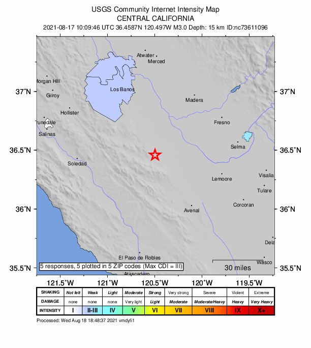
Did you feel it?
5 people reported to the USGS what they felt; the strongest reported shaking was III, weak shaking.
How well it is located
Reviewed by a seismologist.
- Location uncertainty
- About 0.4 km horizontally, 0.8 km in depth
- Magnitude uncertainty
- ±0.19
- Depth from
- From location
- Station coverage gap
- 103°
- Stations used
- 60
Nearest places
Distance and direction from each place to the epicenter, with its forecast.
Nearby
Within 100 km, magnitude 1.5 and up: 101 in the 60 days after this one and 57 in the 30 days before it.
After
- 2.99km SW of Tres Pinos, CA · 1873 days ago · 3 km deep · 86 km away · felt by 8
- 1.97km NNE of Greenfield, CA · 1872 days ago · 4 km deep · 64 km away · felt by 1
- 3.15km S of Ridgemark, CA · 1869 days ago · 9 km deep · 86 km away · felt by 17
- 1.96km ESE of Pinnacles, CA · 1869 days ago · 6 km deep · 53 km away
- 1.817km N of New Idria, CA · 1867 days ago · 10 km deep · 19 km away
- 1.65km NW of Parkfield, CA · 1867 days ago · 5 km deep · 59 km away
- 1.624km SSW of Los Banos, CA · 1867 days ago · 2 km deep · 64 km away
- 1.619km NNW of Coalinga, CA · 1867 days ago · 8 km deep · 19 km away
- 1.824km SSW of Los Banos, CA · 1867 days ago · 6 km deep · 63 km away
- 1.925km SSW of South Dos Palos, CA · 1866 days ago · 2 km deep · 38 km away
- 1.923km NW of Parkfield, CA · 1864 days ago · 6 km deep · 49 km away · felt by 1
- 1.825km NW of Parkfield, CA · 1863 days ago · 5 km deep · 46 km away
- 2.111km SSW of Fairmead, CA · 1863 days ago · 18 km deep · 63 km away
- 2.012km NW of Pinnacles, CA · 1863 days ago · 5 km deep · 68 km away
- 2.012km S of Home Garden, CA · 1863 days ago · 26 km deep · 85 km away
- 2.11km NE of Pinnacles, CA · 1863 days ago · 9 km deep · 57 km away
- 1.720km SW of New Idria, CA · 1861 days ago · 10 km deep · 36 km away
- 1.77km ENE of Pinnacles, CA · 1861 days ago · 12 km deep · 53 km away · felt by 1
- 1.57km NNW of Cholame, CA · 1861 days ago · 4 km deep · 77 km away
- 1.813km N of San Simeon, CA · 1861 days ago · 9 km deep · 100 km away
- 1.88km NW of Pinnacles, CA · 1861 days ago · 7 km deep · 64 km away · felt by 2
- 1.74km N of Pinnacles, CA · 1860 days ago · 6 km deep · 59 km away
- 1.718km SSW of Gustine, CA · 1860 days ago · 7 km deep · 88 km away
- 2.017km N of San Simeon, CA · 1860 days ago · 10 km deep · 98 km away
- 4.06km NW of Pinnacles, CA · 1859 days ago · 9 km deep · 63 km away · felt by 265 · tsunami flag
- 2.19km SE of Pinnacles, CA · 1858 days ago · 6 km deep · 51 km away
- 1.58km NNW of Pinnacles, CA · 1856 days ago · 7 km deep · 63 km away
- 1.913km SSE of Tres Pinos, CA · 1854 days ago · 6 km deep · 75 km away
- 2.515km SSE of Tres Pinos, CA · 1851 days ago · 5 km deep · 73 km away · felt by 3
- 1.67km NNW of Pinnacles, CA · 1850 days ago · 8 km deep · 63 km away
- 1.78km S of Gustine, CA · 1849 days ago · 9 km deep · 93 km away
- 2.216km NW of Pinnacles, CA · 1849 days ago · 4 km deep · 71 km away
- 1.723km WSW of New Idria, CA · 1849 days ago · 8 km deep · 39 km away
- 2.17km NNW of Pinnacles, CA · 1849 days ago · 8 km deep · 63 km away
- 2.08km N of Pinnacles, CA · 1849 days ago · 9 km deep · 60 km away
- 2.015km NW of Pinnacles, CA · 1847 days ago · 10 km deep · 70 km away · felt by 1
- 1.99km NNW of Avenal, CA · 1846 days ago · 12 km deep · 51 km away
- 2.313km NNE of Cambria, CA · 1846 days ago · 7 km deep · 99 km away · felt by 2
- 3.815km SSE of New Idria, CA · 1845 days ago · 17 km deep · 20 km away · felt by 29
- 1.88km ESE of Pinnacles, CA · 1845 days ago · 3 km deep · 52 km away
- 2.35km SSE of Parkfield, CA · 1844 days ago · 5 km deep · 67 km away
- 1.613km NW of Avenal, CA · 1844 days ago · 11 km deep · 47 km away
- 2.823km NW of Parkfield, CA · 1844 days ago · 4 km deep · 47 km away · felt by 2
- 2.07km NNW of Pinnacles, CA · 1843 days ago · 7 km deep · 63 km away
- 1.59km SSW of Tres Pinos, CA · 1843 days ago · 1 km deep · 84 km away
- 1.813km SE of Pinnacles, CA · 1842 days ago · 0 km deep · 48 km away
- 2.122km NE of San Lucas, CA · 1842 days ago · 7 km deep · 38 km away
- 2.012km NNE of Hollister, CA · 1841 days ago · 8 km deep · 91 km away · felt by 1
- 1.96km NNE of Los Banos, CA · 1841 days ago · 5 km deep · 77 km away
- 2.05km NNE of Los Banos, CA · 1841 days ago · 5 km deep · 77 km away
- 2.15km NNE of Los Banos, CA · 1841 days ago · 6 km deep · 76 km away
- 2.46km NNE of Los Banos, CA · 1841 days ago · 6 km deep · 77 km away · felt by 4
- 2.010km SE of Pinnacles, CA · 1841 days ago · 9 km deep · 50 km away
- 2.112km NNE of Hollister, CA · 1840 days ago · 7 km deep · 91 km away · felt by 2
- 1.57km NNW of Pinnacles, CA · 1839 days ago · 8 km deep · 63 km away
- 1.52km NNE of Pinnacles, CA · 1839 days ago · 6 km deep · 58 km away
- 1.913km SSW of Tres Pinos, CA · 1838 days ago · 10 km deep · 83 km away
- 1.98km NW of Pinnacles, CA · 1838 days ago · 8 km deep · 64 km away
- 1.816km N of New Idria, CA · 1838 days ago · 6 km deep · 17 km away
- 2.017km NW of New Idria, CA · 1837 days ago · 4 km deep · 27 km away
The first 60 of 101.
Before
- 2.112km W of Cantua Creek, CA · 1873 days ago · 17 km deep · 5 km away
- 2.410km NW of Pinnacles, CA · 1873 days ago · 3 km deep · 66 km away · felt by 2
- 2.62km SSE of Parkfield, CA · 1875 days ago · 6 km deep · 64 km away · felt by 3
- 1.92km WNW of Tres Pinos, CA · 1875 days ago · 9 km deep · 84 km away
- 2.113km NW of Parkfield, CA · 1875 days ago · 10 km deep · 53 km away
- 2.04km ESE of Pinnacles, CA · 1875 days ago · 11 km deep · 55 km away · felt by 1
- 2.110km SSW of Stratford, CA · 1876 days ago · 2 km deep · 69 km away
- 1.69km ENE of Pinnacles, CA · 1876 days ago · 4 km deep · 51 km away
- 2.710km NNW of Pinnacles, CA · 1877 days ago · 6 km deep · 64 km away · felt by 5
- 2.210km NNW of Pinnacles, CA · 1877 days ago · 6 km deep · 63 km away
- 2.010km NNW of Pinnacles, CA · 1877 days ago · 5 km deep · 63 km away
- 2.510km NNW of Pinnacles, CA · 1877 days ago · 5 km deep · 63 km away · felt by 1
- 1.912km SSW of Cantua Creek, CA · 1877 days ago · 2 km deep · 14 km away
- 1.96km NNE of Pinnacles, CA · 1878 days ago · 9 km deep · 56 km away
- 1.78km WNW of Huron, CA · 1878 days ago · 10 km deep · 38 km away
- 1.513km WNW of Huron, CA · 1880 days ago · 10 km deep · 34 km away
- 1.923km NNE of San Ardo, CA · 1880 days ago · 9 km deep · 38 km away
- 1.616km SE of Pinnacles, CA · 1880 days ago · 3 km deep · 46 km away
- 1.810km SE of Home Garden, CA · 1881 days ago · 21 km deep · 87 km away
- 1.95km NE of Pinnacles, CA · 1881 days ago · 9 km deep · 56 km away
Earthquakes todayCalifornia earthquakesLive radar here
Sources
From the USGS Earthquake Hazards Program and its partner networks, event nc73611096 (also filed as us6000f7h7). Read Sat, Oct 3, 2026, 5:15 PM UTC.