M3.4 earthquake 47 km W of Nanwalek, Alaska
A magnitude 3.4 earthquake struck 47 km W of Nanwalek, Alaska on Mon, Jan 11, 2021, 5:34 AM AKST (14:34 UTC), 80 km (50 mi) below the surface.
A larger quake followed: M4.3 72 km SSW of Nanwalek, Alaska. This one was a foreshock.
Map
Where this earthquake was located, with the others nearby. Select one for its page.
The earthquake
- Magnitude
- 3.4 (ml), minor
- Local time
- UTC
- 2021-01-11 14:34:24 UTC
- Depth
- 80.1 km (49.8 mi), intermediate-depth
- Epicenter
- 59.442° N, 152.748° W
- Region
- Alaska
- Felt reports
- 2
- Tsunami flag
- No
- Status
- Reviewed by a seismologist
Did you feel it?
2 people reported to the USGS what they felt; the strongest reported shaking was III, weak shaking.
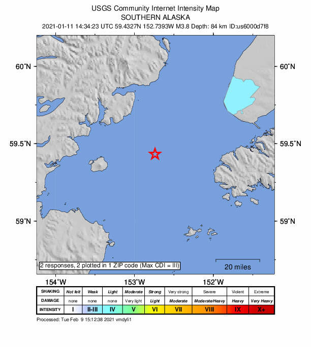
How well it is located
Reviewed by a seismologist.
- Stations used
- 237
Nearest places
Distance and direction from each place to the epicenter, with its forecast.
Nearby
Within 100 km, magnitude 1.5 and up: at least 201 in the 60 days after this one and at least 200 in the 30 days before it.
After
- 1.975 km SW of Nanwalek, Alaska · 2087 days ago · 75 km deep · 57 km away
- 2.351 km WNW of Happy Valley, Alaska · 2087 days ago · 90 km deep · 75 km away
- 2.331 km NW of Nanwalek, Alaska · 2087 days ago · 67 km deep · 25 km away
- 2.245 km NE of Pedro Bay, Alaska · 2087 days ago · 139 km deep · 75 km away
- 1.655 km WNW of Anchor Point, Alaska · 2087 days ago · 87 km deep · 58 km away
- 3.621 km E of Pedro Bay, Alaska · 2087 days ago · 147 km deep · 65 km away
- 1.977 km WNW of Ninilchik, Alaska · 2087 days ago · 122 km deep · 100 km away
- 1.656 km WNW of Ninilchik, Alaska · 2087 days ago · 100 km deep · 80 km away
- 1.883 km NNW of Aleneva, Alaska · 2087 days ago · 6 km deep · 90 km away
- 2.022 km WNW of Ninilchik, Alaska · 2087 days ago · 72 km deep · 85 km away
- 1.951 km E of Pedro Bay, Alaska · 2087 days ago · 104 km deep · 41 km away
- 1.948 km ESE of Port Alsworth, Alaska · 2086 days ago · 159 km deep · 84 km away
- 2.040 km NE of Pedro Bay, Alaska · 2086 days ago · 142 km deep · 80 km away
- 1.756 km WNW of Happy Valley, Alaska · 2086 days ago · 97 km deep · 74 km away
- 1.721 km WSW of Nanwalek, Alaska · 2086 days ago · 70 km deep · 36 km away
- 2.551 km ENE of Pedro Bay, Alaska · 2086 days ago · 115 km deep · 57 km away
- 1.88 km SE of Ninilchik, Alaska · 2086 days ago · 61 km deep · 91 km away
- 1.97 km WNW of Ninilchik, Alaska · 2086 days ago · 58 km deep · 88 km away
- 1.948 km ENE of Pedro Bay, Alaska · 2086 days ago · 148 km deep · 62 km away
- 1.662 km WNW of Nanwalek, Alaska · 2086 days ago · 93 km deep · 20 km away
- 1.668 km ENE of Pedro Bay, Alaska · 2086 days ago · 112 km deep · 75 km away
- 1.761 km WNW of Ninilchik, Alaska · 2086 days ago · 105 km deep · 97 km away
- 1.873 km WNW of Happy Valley, Alaska · 2086 days ago · 126 km deep · 81 km away
- 1.669 km WNW of Happy Valley, Alaska · 2086 days ago · 116 km deep · 77 km away
- 1.863 km ENE of Pedro Bay, Alaska · 2085 days ago · 1 km deep · 70 km away
- 1.742 km WNW of Happy Valley, Alaska · 2085 days ago · 98 km deep · 68 km away
- 1.554 km W of Anchor Point, Alaska · 2085 days ago · 91 km deep · 40 km away
- 1.644 km WSW of Anchor Point, Alaska · 2085 days ago · 99 km deep · 25 km away
- 2.070 km ENE of Pedro Bay, Alaska · 2085 days ago · 116 km deep · 74 km away
- 2.469 km W of Happy Valley, Alaska · 2085 days ago · 104 km deep · 69 km away
- 1.864 km ESE of Pedro Bay, Alaska · 2085 days ago · 98 km deep · 22 km away
- 1.553 km W of Happy Valley, Alaska · 2085 days ago · 101 km deep · 63 km away
- 1.756 km W of Anchor Point, Alaska · 2084 days ago · 89 km deep · 47 km away
- 1.6Southern Alaska · 2084 days ago · 80 km deep · 52 km away
- 1.955 km WNW of Happy Valley, Alaska · 2084 days ago · 105 km deep · 68 km away
- 1.967 km WSW of Nanwalek, Alaska · 2083 days ago · 69 km deep · 47 km away
- 1.853 km W of Nanwalek, Alaska · 2083 days ago · 76 km deep · 6 km away
- 1.816 km WNW of Happy Valley, Alaska · 2083 days ago · 66 km deep · 76 km away
- 1.648 km WNW of Ninilchik, Alaska · 2083 days ago · 95 km deep · 81 km away
- 1.576 km SE of Kokhanok, Alaska · 2083 days ago · 10 km deep · 83 km away
- 1.725 km W of Ninilchik, Alaska · 2083 days ago · 70 km deep · 78 km away
- 1.863 km WNW of Nanwalek, Alaska · 2083 days ago · 97 km deep · 17 km away
- 1.773 km SW of Nanwalek, Alaska · 2083 days ago · 69 km deep · 53 km away
- 2.327 km E of Pedro Bay, Alaska · 2082 days ago · 135 km deep · 65 km away
- 1.755 km E of Pedro Bay, Alaska · 2082 days ago · 106 km deep · 54 km away
- 1.870 km WNW of Ninilchik, Alaska · 2082 days ago · 117 km deep · 83 km away
- 2.133 km SE of Pedro Bay, Alaska · 2082 days ago · 118 km deep · 56 km away
- 2.282 km NNW of Aleneva, Alaska · 2082 days ago · 64 km deep · 84 km away
- 2.217 km S of Nanwalek, Alaska · 2082 days ago · 48 km deep · 52 km away
- 2.165 km ESE of Pedro Bay, Alaska · 2082 days ago · 99 km deep · 21 km away
- 2.137 km ESE of Pedro Bay, Alaska · 2082 days ago · 121 km deep · 50 km away
- 1.836 km WSW of Nanwalek, Alaska · 2082 days ago · 72 km deep · 21 km away
- 1.663 km E of Pedro Bay, Alaska · 2081 days ago · 107 km deep · 52 km away
- 1.863 km E of Pedro Bay, Alaska · 2081 days ago · 112 km deep · 47 km away
- 1.628 km NW of Ninilchik, Alaska · 2080 days ago · 84 km deep · 98 km away
- 2.066 km W of Nanwalek, Alaska · 2080 days ago · 75 km deep · 21 km away
- 1.711 km NE of Nikolaevsk, Alaska · 2080 days ago · 68 km deep · 87 km away
- 1.916 km W of Happy Valley, Alaska · 2080 days ago · 78 km deep · 67 km away
- 2.258 km E of Pedro Bay, Alaska · 2080 days ago · 100 km deep · 45 km away
- 2.14 km WNW of Happy Valley, Alaska · 2079 days ago · 66 km deep · 79 km away
The first 60 of at least 201.
Before
- 1.9Southern Alaska · 2087 days ago · 135 km deep · 89 km away
- 1.865 km W of Nanwalek, Alaska · 2087 days ago · 71 km deep · 19 km away
- 1.927 km WNW of Ninilchik, Alaska · 2087 days ago · 78 km deep · 80 km away
- 2.3Southern Alaska · 2088 days ago · 103 km deep · 39 km away
- 2.320 km NE of Pedro Bay, Alaska · 2088 days ago · 156 km deep · 81 km away
- 1.864 km WNW of Happy Valley, Alaska · 2088 days ago · 106 km deep · 77 km away
- 2.137 km ESE of Port Alsworth, Alaska · 2088 days ago · 176 km deep · 87 km away
- 2.144 km SE of Pedro Bay, Alaska · 2088 days ago · 118 km deep · 43 km away
- 2.055 km E of Port Alsworth, Alaska · 2089 days ago · 135 km deep · 87 km away
- 2.12 km NNW of Anchor Point, Alaska · 2089 days ago · 61 km deep · 65 km away
- 2.059 km WNW of Anchor Point, Alaska · 2089 days ago · 104 km deep · 51 km away
- 2.247 km WNW of Nanwalek, Alaska · 2089 days ago · 72 km deep · 3 km away
- 1.864 km WNW of Ninilchik, Alaska · 2089 days ago · 112 km deep · 89 km away
- 1.965 km ENE of Pedro Bay, Alaska · 2089 days ago · 118 km deep · 57 km away
- 1.860 km E of Port Alsworth, Alaska · 2089 days ago · 132 km deep · 84 km away
- 1.710 km WSW of Nanwalek, Alaska · 2089 days ago · 75 km deep · 40 km away
- 1.544 km WNW of Anchor Point, Alaska · 2089 days ago · 88 km deep · 48 km away
- 1.739 km W of Anchor Point, Alaska · 2089 days ago · 81 km deep · 41 km away
- 1.852 km W of Anchor Point, Alaska · 2089 days ago · 90 km deep · 47 km away
- 2.367 km E of Port Alsworth, Alaska · 2090 days ago · 126 km deep · 85 km away
Earthquakes todayAlaska earthquakesLive radar here
Sources
From the USGS Earthquake Hazards Program and its partner networks, event ak021ifg83p (also filed as ak021ifg81u, us6000d7f8). Read Tue, Sep 29, 2026, 8:52 PM UTC.