M3.8 earthquake 97 km SSE of King Cove, Alaska
A magnitude 3.8 earthquake struck 97 km SSE of King Cove, Alaska on Sat, Jun 12, 2021, 3:46 AM AKDT (11:46 UTC), 35 km (22 mi) below the surface.
Map
Where this earthquake was located, with the others nearby. Select one for its page.
The earthquake
- Magnitude
- 3.8 (mb), minor
- Local time
- UTC
- 2021-06-12 11:46:24 UTC
- Depth
- 35.0 km (21.7 mi), shallow
- Epicenter
- 54.331° N, 161.492° W
- Region
- Alaska
- Strongest shaking
- II, weak shaking
- Tsunami flag
- No
- Status
- Reviewed by a seismologist
Shaking
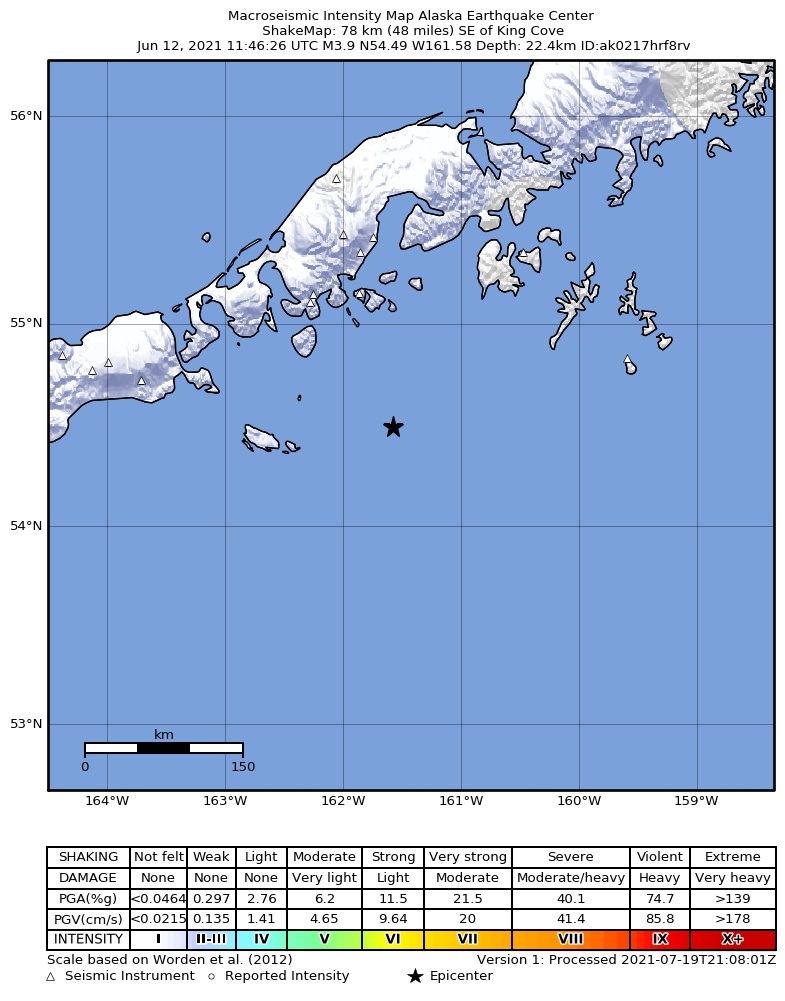
The USGS ShakeMap: shaking estimated from seismic stations and the quake’s size, on the Modified Mercalli intensity scale.
- Strongest estimated
- II, weak shaking
- Peak ground acceleration
- 0.1% of gravity
- Peak ground velocity
- -3.0 cm/s
- Map
- Automatic
Did you feel it?
No one has reported feeling this quake to the USGS.
How well it is located
Reviewed by a seismologist.
- Location uncertainty
- About 4.6 km horizontally, 2.0 km in depth
- Magnitude uncertainty
- ±0.18
- Depth from
- Operator assigned
- Station coverage gap
- 173°
- Stations used
- 81
Nearest places
Distance and direction from each place to the epicenter, with its forecast.
Nearby
Within 100 km, magnitude 1.5 and up: 89 in the 60 days after this one and 19 in the 30 days before it.
After
- 1.997 km SE of King Cove, Alaska · 1930 days ago · 7 km deep · 24 km away
- 3.398 km SSE of Sand Point, Alaska · 1928 days ago · 35 km deep · 99 km away
- 1.666 km SE of King Cove, Alaska · 1927 days ago · 26 km deep · 31 km away
- 2.893 km SSE of False Pass, Alaska · 1927 days ago · 35 km deep · 99 km away
- 1.685 km SE of False Pass, Alaska · 1926 days ago · 10 km deep · 66 km away
- 1.693 km SSW of Sand Point, Alaska · 1926 days ago · 13 km deep · 46 km away
- 3.281 km SE of False Pass, Alaska · 1926 days ago · 27 km deep · 79 km away
- 3.295 km SE of King Cove, Alaska · 1925 days ago · 10 km deep · 16 km away
- 2.5Alaska Peninsula · 1924 days ago · 20 km deep · 85 km away
- 2.788 km SSW of Sand Point, Alaska · 1923 days ago · 35 km deep · 40 km away
- 1.547 km SE of False Pass, Alaska · 1917 days ago · 10 km deep · 96 km away
- 1.571 km SSE of King Cove, Alaska · 1917 days ago · 36 km deep · 30 km away
- 1.679 km SE of King Cove, Alaska · 1917 days ago · 13 km deep · 24 km away
- 2.076 km SE of King Cove, Alaska · 1914 days ago · 23 km deep · 21 km away
- 2.6101 km SSE of King Cove, Alaska · 1913 days ago · 35 km deep · 5 km away
- 2.698 km SE of King Cove, Alaska · 1913 days ago · 10 km deep · 10 km away
- 1.856 km SSE of Sand Point, Alaska · 1912 days ago · 26 km deep · 96 km away
- 2.637 km WSW of Sand Point, Alaska · 1912 days ago · 71 km deep · 99 km away
- 1.663 km SE of King Cove, Alaska · 1912 days ago · 18 km deep · 34 km away
- 1.993 km SE of King Cove, Alaska · 1911 days ago · 26 km deep · 5 km away
- 1.875 km SSE of Sand Point, Alaska · 1910 days ago · 25 km deep · 98 km away
- 2.054 km S of Sand Point, Alaska · 1906 days ago · 21 km deep · 95 km away
- 1.758 km SSE of Sand Point, Alaska · 1906 days ago · 26 km deep · 95 km away
- 1.9106 km SSE of Sand Point, Alaska · 1906 days ago · 5 km deep · 100 km away
- 2.180 km S of Sand Point, Alaska · 1903 days ago · 26 km deep · 68 km away
- 1.750 km ESE of False Pass, Alaska · 1902 days ago · 101 km deep · 86 km away
- 1.590 km S of Sand Point, Alaska · 1902 days ago · 26 km deep · 64 km away
- 1.891 km SE of King Cove, Alaska · 1901 days ago · 7 km deep · 20 km away
- 1.5104 km SE of King Cove, Alaska · 1901 days ago · 11 km deep · 10 km away
- 1.789 km SSW of Sand Point, Alaska · 1901 days ago · 5 km deep · 51 km away
- 2.297 km SSW of Sand Point, Alaska · 1901 days ago · 5 km deep · 47 km away
- 1.559 km SE of King Cove, Alaska · 1900 days ago · 36 km deep · 39 km away
- 2.290 km SE of King Cove, Alaska · 1900 days ago · 13 km deep · 10 km away
- 1.996 km SSE of Sand Point, Alaska · 1899 days ago · 26 km deep · 98 km away
- 2.294 km SE of King Cove, Alaska · 1899 days ago · 11 km deep · 23 km away
- 2.254 km S of Sand Point, Alaska · 1898 days ago · 22 km deep · 94 km away
- 2.657 km S of Sand Point, Alaska · 1898 days ago · 23 km deep · 93 km away
- 2.194 km SSE of False Pass, Alaska · 1898 days ago · 32 km deep · 93 km away
- 1.970 km S of King Cove, Alaska · 1897 days ago · 55 km deep · 60 km away
- 1.784 km SSW of Sand Point, Alaska · 1897 days ago · 20 km deep · 47 km away
- 2.075 km SE of King Cove, Alaska · 1897 days ago · 38 km deep · 22 km away
- 1.687 km SE of King Cove, Alaska · 1897 days ago · 30 km deep · 30 km away
- 1.8103 km SSE of Sand Point, Alaska · 1897 days ago · 42 km deep · 92 km away
- 1.646 km SE of King Cove, Alaska · 1897 days ago · 8 km deep · 51 km away
- 3.0110 km SSW of Sand Point, Alaska · 1896 days ago · 8 km deep · 36 km away
- 1.837 km SSE of King Cove, Alaska · 1896 days ago · 60 km deep · 63 km away
- 2.3Alaska Peninsula · 1896 days ago · 13 km deep · 71 km away
- 2.579 km S of Sand Point, Alaska · 1896 days ago · 13 km deep · 69 km away
- 2.179 km SSE of False Pass, Alaska · 1895 days ago · 13 km deep · 98 km away
- 2.220 km S of King Cove, Alaska · 1895 days ago · 79 km deep · 81 km away
- 1.889 km S of Sand Point, Alaska · 1895 days ago · 26 km deep · 63 km away
- 2.0103 km SSE of Sand Point, Alaska · 1895 days ago · 21 km deep · 97 km away
- 2.390 km SE of King Cove, Alaska · 1894 days ago · 13 km deep · 13 km away
- 1.771 km S of Sand Point, Alaska · 1894 days ago · 12 km deep · 67 km away
- 2.477 km SSE of Sand Point, Alaska · 1894 days ago · 13 km deep · 93 km away
- 2.066 km SSE of King Cove, Alaska · 1893 days ago · 17 km deep · 31 km away
- 3.584 km ESE of King Cove, Alaska · 1893 days ago · 30 km deep · 44 km away
- 2.071 km SSE of King Cove, Alaska · 1893 days ago · 35 km deep · 41 km away
- 2.168 km SSE of King Cove, Alaska · 1891 days ago · 17 km deep · 29 km away
- 1.890 km SE of King Cove, Alaska · 1891 days ago · 13 km deep · 10 km away
The first 60 of 89.
Before
- 1.995 km SSW of Sand Point, Alaska · 1934 days ago · 26 km deep · 41 km away
- 2.559 km S of King Cove, Alaska · 1934 days ago · 53 km deep · 55 km away
- 2.6117 km SE of King Cove, Alaska · 1938 days ago · 21 km deep · 28 km away
- 1.982 km SSE of King Cove, Alaska · 1938 days ago · 46 km deep · 16 km away
- 2.777 km ESE of King Cove, Alaska · 1944 days ago · 34 km deep · 44 km away
- 2.0106 km SE of King Cove, Alaska · 1945 days ago · 5 km deep · 30 km away
- 1.873 km SSE of King Cove, Alaska · 1946 days ago · 14 km deep · 34 km away
- 1.854 km ESE of King Cove, Alaska · 1947 days ago · 59 km deep · 63 km away
- 4.192 km SSE of Sand Point, Alaska · 1953 days ago · 34 km deep · 88 km away
- 3.2115 km S of Sand Point, Alaska · 1955 days ago · 7 km deep · 43 km away
- 2.070 km SSE of King Cove, Alaska · 1956 days ago · 5 km deep · 27 km away
- 2.691 km SSE of King Cove, Alaska · 1956 days ago · 11 km deep · 6 km away
- 2.766 km S of Sand Point, Alaska · 1957 days ago · 32 km deep · 76 km away
- 2.082 km SSE of King Cove, Alaska · 1957 days ago · 5 km deep · 14 km away
- 2.4110 km S of King Cove, Alaska · 1959 days ago · 6 km deep · 53 km away
- 1.681 km SSE of Sand Point, Alaska · 1961 days ago · 19 km deep · 90 km away
- 3.662 km SSW of Sand Point, Alaska · 1961 days ago · 37 km deep · 72 km away
- 1.627 km S of King Cove, Alaska · 1962 days ago · 72 km deep · 76 km away
- 1.569 km ESE of King Cove, Alaska · 1963 days ago · 47 km deep · 53 km away
Earthquakes todayAlaska earthquakesLive radar here
Sources
From the USGS Earthquake Hazards Program and its partner networks, event us7000ecer (also filed as ak0217hrf8rv). Read Sun, Sep 27, 2026, 12:40 AM UTC.