M3.2 earthquake 28km NE of Indio, CA
A magnitude 3.2 earthquake struck 28km NE of Indio, CA on Tue, Sep 21, 2021, 4:15 AM PDT (11:15 UTC), 5 km (3 mi) below the surface.
A larger quake followed: M3.4 10km NNW of Anza, CA. This one was a foreshock.
Map
Where this earthquake was located, with the others nearby. Select one for its page.
The earthquake
- Magnitude
- 3.2 (ML, local (Richter)), minor
- Magnitude from
- Southern California Seismic Network
- Local time
- UTC
- 2021-09-21 11:15:56 UTC
- Depth
- 5.0 km (3.1 mi), shallow
- Epicenter
- 33.874° N, 115.969° W
- Region
- California
- Felt reports
- 18
- Tsunami flag
- No
- Status
- Reviewed by a seismologist
Magnitude estimates
Different scales measure different things and differ by a few tenths. The USGS marks one as preferred, and it is the one this page uses.
| Mag. | Scale | Computed by | Notes |
|---|---|---|---|
| 3.19 | ML, local (Richter) | Southern California Seismic Network | Preferred · Final · ±0.133 · 158 stations |
| 3.2 | ML, local (Richter) | USGS National Earthquake Information Center | Reviewed · ±0.053 · 46 stations |
Did you feel it?
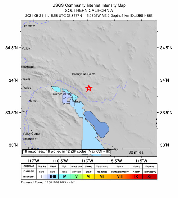
18 people reported to the USGS what they felt; the strongest reported shaking was III, weak shaking.
How well it is located
Reviewed by a seismologist.
- Location uncertainty
- About 0.1 km horizontally, 0.6 km in depth
- Magnitude uncertainty
- ±0.13
- Depth from
- From location
- Station coverage gap
- 49°
- Stations used
- 82
Nearest places
Distance and direction from each place to the epicenter, with its forecast.
Nearby
Within 100 km, magnitude 1.5 and up: 120 in the 60 days after this one and 82 in the 30 days before it.
After
- 1.713km SE of Big Bear City, CA · 1839 days ago · 0 km deep · 79 km away
- 2.45km SE of Valle Vista, CA · 1839 days ago · 17 km deep · 83 km away · felt by 10
- 1.813km SE of Big Bear City, CA · 1839 days ago · 1 km deep · 79 km away
- 2.17km N of Westmorland, CA · 1839 days ago · 10 km deep · 92 km away
- 3.410km NNW of Anza, CA · 1838 days ago · 13 km deep · 74 km away · felt by 296
- 1.610km NNW of Anza, CA · 1838 days ago · 14 km deep · 72 km away
- 1.610km S of Idyllwild, CA · 1838 days ago · 13 km deep · 72 km away
- 1.610km S of Idyllwild, CA · 1838 days ago · 14 km deep · 72 km away
- 1.510km NNW of Anza, CA · 1838 days ago · 14 km deep · 72 km away
- 2.19km NNW of Anza, CA · 1838 days ago · 13 km deep · 73 km away · felt by 2
- 1.610km NNW of Anza, CA · 1838 days ago · 13 km deep · 73 km away
- 3.310km NNW of Anza, CA · 1838 days ago · 13 km deep · 74 km away · felt by 143
- 1.910km NNW of Anza, CA · 1838 days ago · 13 km deep · 73 km away
- 2.310km NNW of Anza, CA · 1838 days ago · 13 km deep · 73 km away
- 1.510km NNW of Anza, CA · 1838 days ago · 14 km deep · 73 km away
- 1.810km NNW of Anza, CA · 1838 days ago · 13 km deep · 73 km away
- 1.710km NNW of Anza, CA · 1838 days ago · 13 km deep · 73 km away · felt by 1
- 1.89km NNW of Anza, CA · 1838 days ago · 13 km deep · 72 km away
- 1.65km SSE of Bombay Beach, CA · 1835 days ago · 3 km deep · 67 km away
- 2.610km S of Borrego Springs, CA · 1835 days ago · 8 km deep · 88 km away · felt by 8
- 1.813km NNE of Banning, CA · 1835 days ago · 14 km deep · 81 km away
- 1.99km NNW of Anza, CA · 1834 days ago · 13 km deep · 73 km away
- 2.06km SW of Banning, CA · 1834 days ago · 7 km deep · 87 km away
- 2.19km SSW of Idyllwild, CA · 1833 days ago · 14 km deep · 76 km away
- 1.815km ENE of Borrego Springs, CA · 1832 days ago · 3 km deep · 69 km away
- 1.720km ENE of Thermal, CA · 1832 days ago · 2 km deep · 17 km away
- 1.67km WSW of Niland, CA · 1831 days ago · 3 km deep · 82 km away
- 3.04km NE of Westmorland, CA · 1831 days ago · 11 km deep · 96 km away · felt by 5
- 1.610km SW of Salton City, CA · 1831 days ago · 10 km deep · 71 km away
- 1.94km NE of Westmorland, CA · 1831 days ago · 8 km deep · 97 km away
- 2.216km ENE of Yucaipa, CA · 1831 days ago · 12 km deep · 89 km away
- 1.97km NNW of Cabazon, CA · 1830 days ago · 14 km deep · 78 km away
- 3.13km NNW of Yucca Valley, CA · 1829 days ago · 7 km deep · 53 km away · felt by 103
- 1.620km ENE of Thermal, CA · 1829 days ago · 3 km deep · 18 km away
- 1.612km ESE of Lucerne Valley, CA · 1828 days ago · 7 km deep · 99 km away
- 1.88km NNE of Borrego Springs, CA · 1827 days ago · 11 km deep · 71 km away
- 1.65km SSE of Ocotillo Wells, CA · 1826 days ago · 10 km deep · 87 km away
- 1.721km ESE of Anza, CA · 1825 days ago · 13 km deep · 65 km away
- 1.54km ENE of Westmorland, CA · 1825 days ago · 8 km deep · 99 km away
- 1.64km ENE of Westmorland, CA · 1825 days ago · 9 km deep · 98 km away
- 2.916km NE of Coachella, CA · 1825 days ago · 7 km deep · 13 km away · felt by 7
- 1.516km NE of Coachella, CA · 1825 days ago · 7 km deep · 13 km away · felt by 1
- 2.74km ENE of Westmorland, CA · 1825 days ago · 11 km deep · 98 km away · felt by 2
- 2.111km NE of Yucaipa, CA · 1820 days ago · 12 km deep · 94 km away · felt by 1
- 1.69km SW of Morongo Valley, CA · 1818 days ago · 18 km deep · 64 km away
- 1.76km NW of San Jacinto, CA · 1818 days ago · 13 km deep · 96 km away
- 1.621km SSE of Salton City, CA · 1817 days ago · 1 km deep · 83 km away
- 1.58km NNW of Borrego Springs, CA · 1816 days ago · 5 km deep · 73 km away
- 1.611km NE of Julian, CA · 1816 days ago · 9 km deep · 95 km away
- 1.59km SW of Niland, CA · 1815 days ago · 2 km deep · 83 km away
- 1.68km SW of Niland, CA · 1814 days ago · 2 km deep · 83 km away
- 1.610km SW of Niland, CA · 1814 days ago · 3 km deep · 83 km away
- 1.63km W of Niland, CA · 1814 days ago · 2 km deep · 80 km away
- 1.68km SW of Niland, CA · 1814 days ago · 2 km deep · 84 km away
- 1.83km W of Niland, CA · 1814 days ago · 2 km deep · 80 km away
- 2.44km WSW of Salton City, CA · 1814 days ago · 3 km deep · 66 km away · felt by 2
- 1.74km W of Niland, CA · 1814 days ago · 3 km deep · 80 km away
- 1.914km S of Joshua Tree, CA · 1813 days ago · 8 km deep · 36 km away
- 1.94km WSW of Borrego Springs, CA · 1813 days ago · 6 km deep · 81 km away
- 2.313km W of Salton City, CA · 1812 days ago · 9 km deep · 66 km away · felt by 3
The first 60 of 120.
Before
- 1.58km W of Calipatria, CA · 1839 days ago · 10 km deep · 90 km away
- 2.119km SW of La Quinta, CA · 1839 days ago · 10 km deep · 58 km away · felt by 3
- 1.76km NNE of Borrego Springs, CA · 1840 days ago · 11 km deep · 72 km away
- 1.913km NNW of Borrego Springs, CA · 1842 days ago · 10 km deep · 69 km away
- 1.55km WSW of Salton City, CA · 1842 days ago · 3 km deep · 66 km away
- 2.76km N of Beaumont, CA · 1843 days ago · 16 km deep · 93 km away · felt by 6
- 2.28km SSE of Big Bear City, CA · 1843 days ago · 11 km deep · 85 km away
- 1.826km N of Yucca Valley, CA · 1843 days ago · 5 km deep · 69 km away · felt by 1
- 1.610km NW of Idyllwild, CA · 1845 days ago · 12 km deep · 75 km away
- 1.64km WSW of Salton City, CA · 1845 days ago · 3 km deep · 66 km away
- 1.99km NNW of Cabazon, CA · 1846 days ago · 20 km deep · 80 km away
- 2.24km NE of Beaumont, CA · 1846 days ago · 17 km deep · 91 km away
- 1.54km ENE of Big Bear City, CA · 1847 days ago · 8 km deep · 89 km away
- 1.57km ENE of Cabazon, CA · 1847 days ago · 11 km deep · 69 km away
- 1.610km S of Borrego Springs, CA · 1849 days ago · 3 km deep · 88 km away
- 1.612km W of Niland, CA · 1849 days ago · 4 km deep · 77 km away
- 1.613km W of Niland, CA · 1850 days ago · 4 km deep · 75 km away
- 1.63km SSE of Yucca Valley, CA · 1850 days ago · 10 km deep · 48 km away
- 1.67km ENE of Cabazon, CA · 1851 days ago · 11 km deep · 69 km away
- 1.84km NE of Beaumont, CA · 1852 days ago · 14 km deep · 91 km away
Earthquakes todayCalifornia earthquakesLive radar here
Sources
From the USGS Earthquake Hazards Program and its partner networks, event ci39814663 (also filed as us7000fd3n). Read Sun, Oct 4, 2026, 8:27 AM UTC.