M5.9 earthquake 11 km NNE of Harnai, Pakistan
A magnitude 5.9 earthquake struck 11 km NNE of Harnai, Pakistan on Thu, Oct 7, 2021, 3:01 AM GMT+5 (22:01 UTC), 9 km (6 mi) below the surface.
Map
Where this earthquake was located, with the others nearby. Select one for its page.
The earthquake
- Magnitude
- 5.9 (Mww, W-phase moment), moderate
- Magnitude from
- USGS National Earthquake Information Center
- Local time
- UTC
- 2021-10-06 22:01:08 UTC
- Depth
- 9.0 km (5.6 mi), shallow
- Epicenter
- 30.193° N, 67.995° E
- Region
- Pakistan
- Felt reports
- 46
- Strongest shaking
- VII, very strong shaking
- PAGER alert
- Yellow
- Tsunami flag
- No
- Status
- Reviewed by a seismologist
Magnitude estimates
Different scales measure different things and differ by a few tenths. The USGS marks one as preferred, and it is the one this page uses.
| Mag. | Scale | Computed by | Notes |
|---|---|---|---|
| 5.9 | Mww, W-phase moment | USGS National Earthquake Information Center | Preferred · Reviewed · ±0.098 · 10 stations |
| 5.96 | Mw, moment | ISC-GEM global catalog | Final · ±0.1 |
| 5.8 | Mi | NOAA National Tsunami Warning Center | First automatic solution · Reviewed · 3 stations |
| 6.1 | Mi | NOAA Pacific Tsunami Warning Center | First automatic solution · Reviewed · 11 stations |
| 6.0 | Mwc, centroid moment | USGS National Earthquake Information Center | Moment tensor · Reviewed |
| 5.9 | Mwb, body-wave moment | USGS National Earthquake Information Center | Moment tensor · Reviewed |
| 5.8 | Mww, W-phase moment | USGS, automatic first solution | First automatic solution · Confirmed |
Deaths and damage
From NOAA NCEI’s Significant Earthquake Database (record 10582), matched to this event by time and place.
- Deaths
- 42
- Injuries
- 229
- Damage
- Moderate (about $1 to $5 million)
- Houses destroyed
- Many (101 to 1,000)
- Houses damaged
- Some (about 51 to 100)
Where the literature gives no number, NCEI records a description on a scale of 1 to 4, printed here in its words. Damage is in millions of US dollars of the year of the event, not adjusted for inflation.
From Wikipedia
An earthquake struck Pakistan's province of Balochistan near the city of Harnai on 7 October 2021. The moment magnitude 5.9 Mww quake struck in the early morning at 03:01 local time, killing at least 42 people and injuring 300 others. The earthquake occurred just one day before the anniversary of the 2005 Kashmir earthquake.
Text from Wikipedia, “2021 Balochistan earthquake”, licensed CC BY-SA 4.0. Quoted as written; the full article has the rest.
The article is about the earthquake NOAA’s record describes, matched to this one by date, place and magnitude.
Wikidata records: 42 deaths and 300 injured. These are counts entered by Wikidata’s editors; they may differ from the official count, and this page never adds them to another figure. Q108822258, CC0.
What happened
The USGS’s account of the effects of this earthquake.
At least 21 people killed, 300 injured and 15 miners missing; more than 1,000 homes damaged or destroyed; landslides blocked roads and power outages occurred in the Harnai area.
From the USGS event page for us6000fsg9. U.S. Geological Survey text and figures are in the public domain.
Shaking
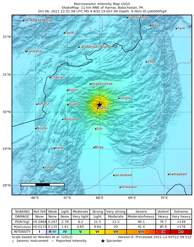
The USGS ShakeMap: shaking estimated from seismic stations and the quake’s size, on the Modified Mercalli intensity scale.
- Strongest estimated
- VII, very strong shaking
- Peak ground acceleration
- 47.1% of gravity
- Peak ground velocity
- 3.3 cm/s
- Map
- Automatic
Did you feel it?
46 people reported to the USGS what they felt; the strongest reported shaking was VIII, severe shaking.

Estimated impact
The USGS PAGER system estimates deaths and economic losses from the shaking and the population and buildings exposed to it.
- Alert level
- Yellow: some damage and deaths possible, a local or regional response
| Range | Chance |
|---|---|
| Under 1 | 12% |
| 1 to 10 | 28% |
| 10 to 100 | 35% |
| 100 to 1,000 | 19% |
| 1,000 to 10,000 | 5% |
| 10,000 to 100,000 | Under 1% |
| 100,000 to 10,000,000 | Under 1% |
| Range, million USD | Chance |
|---|---|
| Under 1 | 11% |
| 1 to 10 | 31% |
| 10 to 100 | 38% |
| 100 to 1,000 | 18% |
| 1,000 to 10,000 | 3% |
| 10,000 to 100,000 | Under 1% |
| 100,000 to 10,000,000 | Under 1% |
Fault motion and ground failure
How the rock slipped, from the moment tensor, and the USGS estimate of landslides and liquefaction.
- Faulting
- Oblique reverse
- Moment magnitude
- 5.9 Mww
- Nodal plane 1
- Strike 292°, dip 20°, rake 144°
- Nodal plane 2
- Strike 57°, dip 78°, rake 74°
- Landslide alert
- Yellow
- Liquefaction alert
- Green
Tectonic setting
Why earthquakes happen here, from the USGS tectonic summary.
On October 6, 2021, an M5.9 earthquake occurred in the north of the Balochistan province of Pakistan, approximately 100 km east of the city of Quetta. The earthquake occurred at shallow crustal depths (approximately 9 km) as the result of thrust faulting on either a fault dipping shallowly to the north, or a fault dipping steeply to the south. The earthquake mechanism, depth, and location are consistent with the earthquake having occurred on or near the shallowly northward dipping plate boundary between the India and Eurasia plates. At the location of the earthquake, the India plate moves north at 29 mm/yr relative to the Eurasia plate.
The October 6, 2021 earthquake occurred near the western edge of the Sulaiman Mountains, a U-shaped active fold-and-thrust belt mountain range in central Pakistan formed at the boundary between the converging Eurasia and India plates. The Sulaiman Mountains are characterized by intense faulting and folding of a thick package (approximately 10 km thick) of sedimentary rocks that are decoupled from underlying crystalline rock of the India plate by a nearly horizontal thrust fault, or decollement, that dips northward beneath the Eurasia plate.
Moderate magnitude (M6+) earthquakes are common in the vicinity of the October 6 earthquake; 21 earthquakes of M6 or larger occurred within 250 km of the October 6 earthquake in the past 100 years. Notably, an M7.1 thrust earthquake with similar faulting characteristics to the October 6 earthquake occurred 40 km to the southeast on February 27, 1997. The 1997 earthquake led to ~100 casualties and strong shaking in Quetta. West of the Sulaiman Mountains, an M7.2 earthquake occurred on August 27, 1931 75 km to the southwest of the October 6 earthquake. An M7.5 earthquake on May 30, 1935 located 205 km southwest of the October 6 earthquake caused widespread destruction in Quetta and approximately 20,000 fatalities.
From the USGS event page for us6000fsg9. U.S. Geological Survey text and figures are in the public domain.
How well it is located
Reviewed by a seismologist.
- Location uncertainty
- About 8.4 km horizontally, 1.7 km in depth
- Magnitude uncertainty
- ±0.10
- Depth from
- From modeling of broad-band P waveforms
- Station coverage gap
- 17°
- Stations used
- 296
Nearest places
Distance and direction from each place to the epicenter, with its forecast.
Nearby
Within 100 km, magnitude 2.9 and up: 3 in the 60 days after this one and 0 in the 30 days before it.
After
Earthquakes todayPakistan earthquakesLive radar here
Sources
From the USGS Earthquake Hazards Program and its partner networks, event us6000fsg9 (also filed as usauto6000fsg9, pt21279051, at00r0kt5v, iscgem621126624). Read Thu, Oct 1, 2026, 5:03 PM UTC.