M5.2 earthquake 49 km ENE of Calama, Chile
A magnitude 5.2 earthquake struck 49 km ENE of Calama, Chile on Thu, May 20, 2021, 2:27 PM GMT-4 (18:27 UTC), 115 km (71 mi) below the surface.
Map
Where this earthquake was located, with the others nearby. Select one for its page.
The earthquake
- Magnitude
- 5.2 (Mww, W-phase moment), moderate
- Magnitude from
- USGS National Earthquake Information Center
- Local time
- UTC
- 2021-05-20 18:27:54 UTC
- Depth
- 114.8 km (71.3 mi), intermediate-depth
- Epicenter
- 22.209° S, 68.520° W
- Region
- Chile
- Felt reports
- 2
- Tsunami flag
- No
- Status
- Reviewed by a seismologist
Magnitude estimates
Different scales measure different things and differ by a few tenths. The USGS marks one as preferred, and it is the one this page uses.
| Mag. | Scale | Computed by | Notes |
|---|---|---|---|
| 5.2 | Mww, W-phase moment | USGS National Earthquake Information Center | Preferred · Reviewed · ±0.062 · 25 stations |
| 5.22 | Mw, moment | ISC-GEM global catalog | Final · ±0.1 |
| 5.2 | Mww, W-phase moment | USGS, automatic first solution | First automatic solution · Confirmed |
Did you feel it?
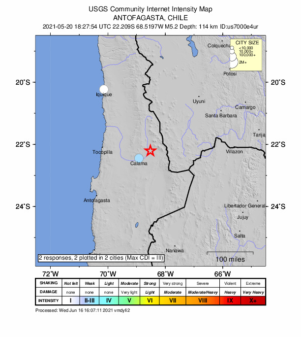
2 people reported to the USGS what they felt; the strongest reported shaking was III, weak shaking.
How well it is located
Reviewed by a seismologist.
- Location uncertainty
- About 6.4 km horizontally, 3.9 km in depth
- Magnitude uncertainty
- ±0.06
- Depth from
- From location
- Station coverage gap
- 37°
- Stations used
- 109
Nearest places
Distance and direction from each place to the epicenter, with its forecast.
Nearby
Within 100 km, magnitude 2.2 and up: 12 in the 60 days after this one and 9 in the 30 days before it.
After
- 4.2101 km NNE of Calama, Chile · 1953 days ago · 149 km deep · 61 km away
- 4.083 km NNE of Calama, Chile · 1949 days ago · 139 km deep · 55 km away
- 4.031 km ENE of Calama, Chile · 1945 days ago · 114 km deep · 20 km away
- 4.2Chile-Bolivia border region · 1931 days ago · 135 km deep · 76 km away
- 4.398 km NNE of Calama, Chile · 1925 days ago · 111 km deep · 60 km away
- 3.924 km E of Calama, Chile · 1924 days ago · 123 km deep · 30 km away
- 4.3134 km NNE of Calama, Chile · 1923 days ago · 110 km deep · 96 km away
- 4.0119 km N of Calama, Chile · 1918 days ago · 126 km deep · 94 km away
- 4.119 km SE of Calama, Chile · 1914 days ago · 109 km deep · 52 km away
- 4.461 km NNE of Calama, Chile · 1912 days ago · 125 km deep · 32 km away
- 4.391 km NNE of Calama, Chile · 1906 days ago · 129 km deep · 55 km away · felt by 1
- 4.690 km NNE of Calama, Chile · 1904 days ago · 147 km deep · 55 km away
Before
- 4.011 km NNE of Calama, Chile · 1962 days ago · 113 km deep · 42 km away
- 4.296 km NNE of Calama, Chile · 1968 days ago · 138 km deep · 61 km away · felt by 1
- 4.449 km NE of Calama, Chile · 1970 days ago · 113 km deep · 8 km away · felt by 1
- 4.3108 km NNE of Calama, Chile · 1970 days ago · 143 km deep · 72 km away · felt by 1
- 4.661 km NNE of Calama, Chile · 1974 days ago · 113 km deep · 39 km away · felt by 1
- 4.448 km NE of Calama, Chile · 1976 days ago · 117 km deep · 9 km away
- 4.369 km NE of San Pedro de Atacama, Chile · 1977 days ago · 187 km deep · 90 km away · felt by 1
- 4.446 km SSE of Calama, Chile · 1977 days ago · 109 km deep · 76 km away
- 4.183 km NNE of Calama, Chile · 1989 days ago · 118 km deep · 51 km away · felt by 1
Earthquakes todayChile earthquakesLive radar here
Sources
From the USGS Earthquake Hazards Program and its partner networks, event us7000e4ur (also filed as usauto7000e4ur, iscgem620433898). Read Fri, Oct 2, 2026, 8:23 PM UTC.