M2.8 earthquake 4 km NW of Aurora, Utah
A magnitude 2.8 earthquake struck 4 km NW of Aurora, Utah on Thu, Jun 24, 2021, 7:52 PM MDT (01:52 UTC), 13 km (8 mi) below the surface.
Map
Where this earthquake was located, with the others nearby. Select one for its page.
The earthquake
- Magnitude
- 2.8 (ML, local (Richter)), micro
- Magnitude from
- University of Utah Seismograph Stations
- Local time
- UTC
- 2021-06-25 01:52:17 UTC
- Depth
- 13.0 km (8.1 mi), shallow
- Epicenter
- 38.947° N, 111.976° W
- Region
- Utah
- Felt reports
- 2
- Tsunami flag
- No
- Status
- Reviewed by a seismologist
Magnitude estimates
Different scales measure different things and differ by a few tenths. The USGS marks one as preferred, and it is the one this page uses.
| Mag. | Scale | Computed by | Notes |
|---|---|---|---|
| 2.75 | ML, local (Richter) | University of Utah Seismograph Stations | Preferred · Final · ±0.178 · 29 stations |
| 3.0 | ML, local (Richter) | USGS National Earthquake Information Center | Reviewed · ±0.03 · 144 stations |
Did you feel it?
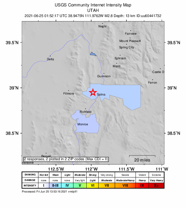
2 people reported to the USGS what they felt; the strongest reported shaking was II, weak shaking.
How well it is located
Reviewed by a seismologist.
- Location uncertainty
- About 0.4 km horizontally, 0.5 km in depth
- Magnitude uncertainty
- ±0.18
- Depth from
- From location
- Station coverage gap
- 54°
- Stations used
- 21
Nearest places
Distance and direction from each place to the epicenter, with its forecast.
Nearby
Within 100 km, magnitude 1.5 and up: 14 in the 60 days after this one and 6 in the 30 days before it.
After
- 1.67 km ENE of Fairview, Utah · 1907 days ago · 8 km deep · 94 km away
- 2.310 km SE of Manti, Utah · 1899 days ago · 17 km deep · 48 km away
- 1.62 km SSW of Manti, Utah · 1897 days ago · 3 km deep · 44 km away
- 1.63 km SSW of Manti, Utah · 1897 days ago · 4 km deep · 43 km away
- 2.217 km NW of Circleville, Utah · 1885 days ago · 11 km deep · 84 km away
- 1.69 km NW of Sterling, Utah · 1884 days ago · 13 km deep · 40 km away
- 1.728 km N of Fremont, Utah · 1883 days ago · 9 km deep · 40 km away
- 1.610 km ESE of Glenwood, Utah · 1877 days ago · 16 km deep · 25 km away
- 2.05 km WSW of Junction, Utah · 1874 days ago · 9 km deep · 85 km away
- 2.84 km SSE of Joseph, Utah · 1870 days ago · 8 km deep · 43 km away
- 2.78 km SSE of Joseph, Utah · 1870 days ago · 11 km deep · 47 km away
- 1.611 km ENE of Fairview, Utah · 1867 days ago · 3 km deep · 97 km away
- 1.920 km SE of Mayfield, Utah · 1867 days ago · 25 km deep · 35 km away
- 1.611 km WNW of Junction, Utah · 1867 days ago · 6 km deep · 83 km away
Before
- 1.820 km ENE of Milford, UT · 1931 days ago · 5 km deep · 89 km away
- 2.58 km N of Richfield, Utah · 1933 days ago · 12 km deep · 14 km away · felt by 3
- 1.515 km ESE of Ephraim, Utah · 1945 days ago · 2 km deep · 61 km away
- 1.62 km SW of Elsinore, Utah · 1949 days ago · 5 km deep · 35 km away
- 1.612 km WSW of Circleville, Utah · 1954 days ago · 8 km deep · 100 km away
- 1.817 km ENE of Milford, Utah · 1955 days ago · 0 km deep · 91 km away
Earthquakes todayUtah earthquakesLive radar here
Sources
From the USGS Earthquake Hazards Program and its partner networks, event uu60441732 (also filed as us6000epjv). Read Fri, Oct 2, 2026, 9:32 PM UTC.