M6.0 earthquake Antelope Valley, CA
A magnitude 6.0 earthquake struck in Antelope Valley, CA on Thu, Jul 8, 2021, 3:49 PM PDT (22:49 UTC), 7 km (5 mi) below the surface.
Map
Where this earthquake was located, with the others nearby. Select one for its page.
The earthquake
- Magnitude
- 6.0 (Mw, moment), strong
- Magnitude from
- Northern California Seismic System
- Local time
- UTC
- 2021-07-08 22:49:48 UTC
- Depth
- 7.5 km (4.6 mi), shallow
- Epicenter
- 38.508° N, 119.500° W
- Region
- California
- Felt reports
- 25,987
- Strongest shaking
- VII, very strong shaking
- PAGER alert
- Green
- Tsunami flag
- No
- Status
- Reviewed by a seismologist
Magnitude estimates
Different scales measure different things and differ by a few tenths. The USGS marks one as preferred, and it is the one this page uses.
| Mag. | Scale | Computed by | Notes |
|---|---|---|---|
| 6.0 | Mw, moment | Northern California Seismic System | Preferred · Final · 0 stations |
| 6.0 | Mww, W-phase moment | USGS National Earthquake Information Center | Reviewed · ±0.02 · 234 stations |
| 5.8 | ML, local (Richter) | Nevada Seismological Laboratory | Reviewed · ±0.21 · 4 stations |
| 4.8 | Mw, moment | EW | Preliminary · ±0.4 · 4 stations |
| 5.95 | Mw, moment | ISC-GEM global catalog | Final · ±0.1 |
| 6.1 | Mi | NOAA Pacific Tsunami Warning Center | First automatic solution · Reviewed · 35 stations |
| 5.93 | Mw, moment | Northern California Seismic System | Moment tensor · Reviewed |
| 5.8 | Mwb, body-wave moment | USGS National Earthquake Information Center | Moment tensor · Reviewed |
| 5.8 | Mwr, regional moment | USGS National Earthquake Information Center | Moment tensor · Reviewed |
| 5.8 | Mwr, regional moment | Nevada Seismological Laboratory | Moment tensor · Reviewed |
| 6.03 | Mw, moment | USGS finite-fault model | Finite-fault model · Reviewed |
What happened
The USGS’s account of the effects of this earthquake.
Rockslides occurred on U.S. Route 395 near Coleville.
From the USGS event page for nc73584926. U.S. Geological Survey text and figures are in the public domain.
Shaking
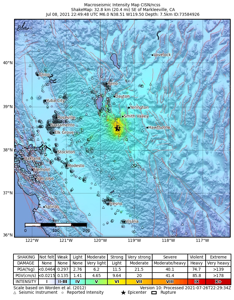
The USGS ShakeMap: shaking estimated from seismic stations and the quake’s size, on the Modified Mercalli intensity scale.
- Strongest estimated
- VII, very strong shaking
- Peak ground acceleration
- 32.7% of gravity
- Peak ground velocity
- 3.2 cm/s
- Map
- Automatic
Did you feel it?
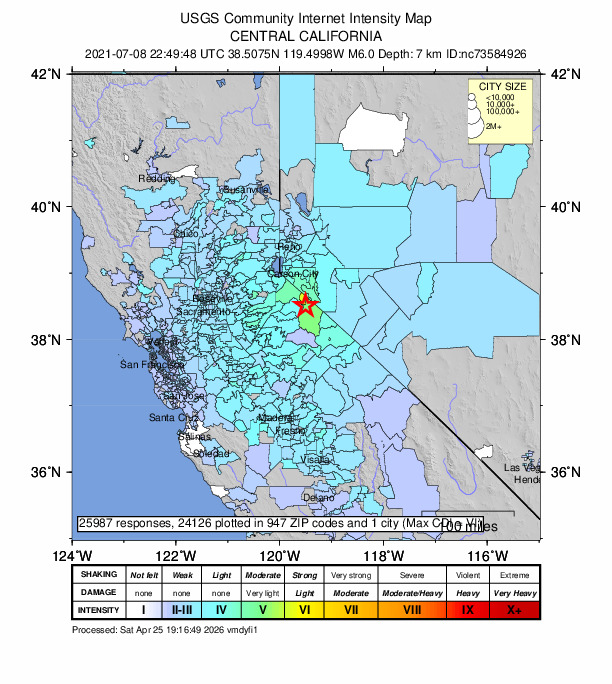
25,987 people reported to the USGS what they felt; the strongest reported shaking was VI, strong shaking.
Estimated impact
The USGS PAGER system estimates deaths and economic losses from the shaking and the population and buildings exposed to it.
- Alert level
- Green: little or no damage or loss of life expected
| Range | Chance |
|---|---|
| Under 1 | 65% |
| 1 to 10 | 30% |
| 10 to 100 | 4% |
| 100 to 1,000 | Under 1% |
| 1,000 to 10,000 | Under 1% |
| 10,000 to 100,000 | Under 1% |
| 100,000 to 10,000,000 | Under 1% |
| Range, million USD | Chance |
|---|---|
| Under 1 | 93% |
| 1 to 10 | 6% |
| 10 to 100 | Under 1% |
| 100 to 1,000 | Under 1% |
| 1,000 to 10,000 | Under 1% |
| 10,000 to 100,000 | Under 1% |
| 100,000 to 10,000,000 | Under 1% |
Fault motion and ground failure
How the rock slipped, from the moment tensor, and the USGS estimate of landslides and liquefaction.
- Moment magnitude
- 5.9 Mw
- Landslide alert
- Yellow
- Liquefaction alert
- Green
Rupture model
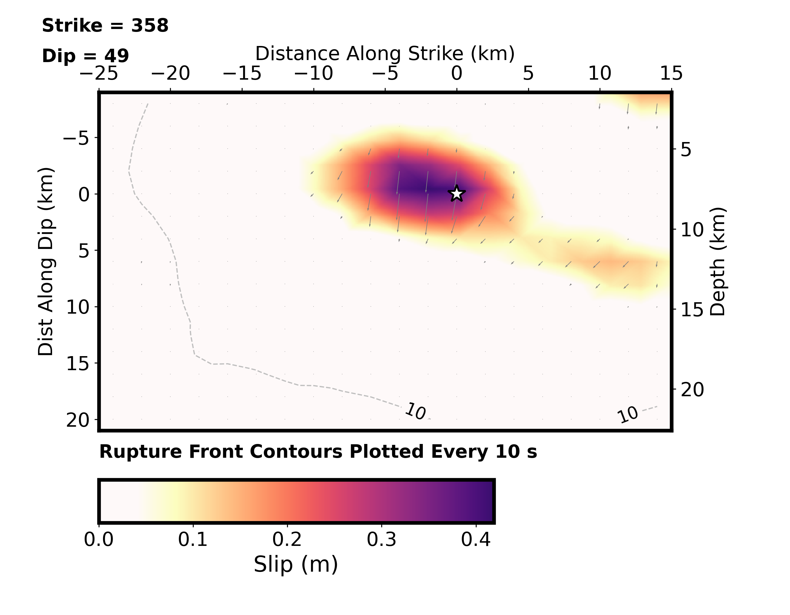
How far the rock on each part of the fault slid, from a model fitted to seismic waves recorded around the world.
Tectonic setting
Why earthquakes happen here, from the USGS tectonic summary.
The July 8, 2021 M 6.0 earthquake in Antelope Valley, California, 32 km south-southwest of Smith Valley, Nevada, occurred as the result of normal faulting in the shallow crust of the North America plate. Preliminary focal mechanism solutions for the event, which describe the style of faulting in an earthquake, indicate slip likely occurred on a moderately dipping fault striking roughly north-south. This motion is consistent with east-west oriented extension that is common in Nevada and eastern California. This earthquake occurred along the eastern edge of the Sierra Nevada, a major physiographic boundary along the California-Nevada border.
Tectonically, this event occurred at the margin of the stable Sierra Nevada microplate and the Walker Lane, a zone of distributed shear. The Sierra Nevada microplate moves at about 12 mm/yr to the northwest relative to the North American plate. The Sierra Nevada microplate is a part of the broader Pacific-North America plate boundary system of California, and roughly 25% of the 5 cm/yr total plate boundary motion occurs east of the Sierra Nevada. Earthquakes in the vicinity of the July 8 earthquake include both normal faulting earthquakes and strike-slip earthquakes.
In the past 100 years, 33 earthquakes of M5+ or larger have occurred within 100 km of the July 8 earthquake. The largest of these were a M6.1 earthquake 36 km to the northwest in September 1994 and a M6.1 earthquake 63 km to the north in June 1933.
From the USGS event page for nc73584926. U.S. Geological Survey text and figures are in the public domain.
How well it is located
Reviewed by a seismologist.
- Location uncertainty
- About 0.1 km horizontally, 0.3 km in depth
- Depth from
- From location
- Station coverage gap
- 100°
- Stations used
- 42
Nearest places
Distance and direction from each place to the epicenter, with its forecast.
Nearby
Within 100 km, magnitude 3.0 and up: 71 in the 60 days after this one and 0 in the 30 days before it.
After
- 5.032km SE of Markleeville, CA · 1914 days ago · 7 km deep · 1 km away · felt by 96
- 3.22 km WNW of Walker, California · 1914 days ago · 4 km deep · 2 km away · felt by 17
- 4.332km SE of Markleeville, CA · 1914 days ago · 7 km deep · 1 km away · felt by 347
- 3.731km SE of Markleeville, CA · 1914 days ago · 7 km deep · 2 km away · felt by 38
- 3.332km ENE of Dardanelle, CA · 1914 days ago · 4 km deep · 3 km away · felt by 5
- 3.131km ENE of Dardanelle, CA · 1914 days ago · 6 km deep · 6 km away
- 3.429km ENE of Dardanelle, CA · 1914 days ago · 3 km deep · 5 km away · felt by 141
- 3.431km SE of Markleeville, CA · 1914 days ago · 5 km deep · 2 km away · felt by 34
- 3.032km ENE of Dardanelle, CA · 1914 days ago · 9 km deep · 2 km away
- 3.030km SE of Markleeville, CA · 1914 days ago · 4 km deep · 3 km away · felt by 45
- 4.629km ENE of Dardanelle, CA · 1914 days ago · 2 km deep · 5 km away · felt by 322
- 3.528km ESE of Markleeville, CA · 1914 days ago · 4 km deep · 5 km away · felt by 1
- 3.828km SE of Markleeville, CA · 1914 days ago · 5 km deep · 4 km away · felt by 49
- 4.229km SE of Markleeville, CA · 1914 days ago · 6 km deep · 4 km away · felt by 93
- 3.628km SE of Markleeville, CA · 1914 days ago · 3 km deep · 4 km away · felt by 3
- 3.931km NW of Bridgeport, CA · 1914 days ago · 5 km deep · 6 km away · felt by 29
- 4.432km ENE of Dardanelle, CA · 1914 days ago · 5 km deep · 3 km away · felt by 121
- 3.129km SE of Markleeville, CA · 1914 days ago · 4 km deep · 4 km away · felt by 5
- 3.330km ENE of Dardanelle, CA · 1914 days ago · 2 km deep · 5 km away · felt by 9
- 4.530km SE of Markleeville, CA · 1914 days ago · 4 km deep · 3 km away · felt by 187
- 3.230km SE of Markleeville, CA · 1914 days ago · 2 km deep · 3 km away · felt by 5
- 3.028km SE of Markleeville, CA · 1914 days ago · 3 km deep · 5 km away · felt by 3
- 3.330km SE of Markleeville, CA · 1914 days ago · -2 km deep · 4 km away · felt by 7
- 3.229km SE of Markleeville, CA · 1914 days ago · 1 km deep · 4 km away · felt by 7
- 3.033km SSW of Smith Valley, NV · 1914 days ago · 7 km deep · 2 km away · felt by 2
- 4.130km SE of Markleeville, CA · 1914 days ago · 6 km deep · 3 km away · felt by 47
- 4.328km SE of Markleeville, CA · 1914 days ago · 4 km deep · 5 km away · felt by 474
- 3.628km SE of Markleeville, CA · 1914 days ago · 5 km deep · 5 km away · felt by 13
- 3.130km ENE of Dardanelle, CA · 1914 days ago · 2 km deep · 5 km away · felt by 2
- 3.528km SSW of Smith Valley, NV · 1914 days ago · 1 km deep · 6 km away · felt by 2
- 3.429km SSW of Smith Valley, NV · 1914 days ago · 1 km deep · 5 km away
- 3.430km SE of Markleeville, CA · 1914 days ago · 6 km deep · 3 km away · felt by 7
- 3.430km ESE of Markleeville, CA · 1914 days ago · 6 km deep · 5 km away · felt by 2
- 3.07 km SW of Walker, California · 1914 days ago · 5 km deep · 6 km away
- 3.329km SSW of Smith Valley, NV · 1914 days ago · 1 km deep · 5 km away · felt by 12
- 3.130km SE of Markleeville, CA · 1913 days ago · 2 km deep · 4 km away · felt by 4
- 3.129km SE of Markleeville, CA · 1913 days ago · 5 km deep · 4 km away · felt by 5
- 3.130km SSW of Smith Valley, NV · 1913 days ago · 0 km deep · 4 km away · felt by 1
- 3.828km SE of Markleeville, CA · 1913 days ago · 2 km deep · 5 km away · felt by 21
- 3.033km SE of Markleeville, CA · 1913 days ago · 6 km deep · 1 km away · felt by 2
- 3.631km SE of Markleeville, CA · 1913 days ago · 3 km deep · 4 km away · felt by 9
- 3.129km ENE of Dardanelle, CA · 1912 days ago · 2 km deep · 5 km away · felt by 1
- 3.130km SE of Markleeville, CA · 1912 days ago · 5 km deep · 3 km away · felt by 2
- 3.329km SE of Markleeville, CA · 1912 days ago · 1 km deep · 4 km away · felt by 10
- 3.928km SSW of Smith Valley, NV · 1909 days ago · 2 km deep · 6 km away · felt by 29
- 3.228km SE of Markleeville, CA · 1909 days ago · 4 km deep · 5 km away · felt by 3
- 3.832km SSW of Smith Valley, NV · 1908 days ago · 5 km deep · 2 km away · felt by 39
- 3.132km ENE of Dardanelle, CA · 1906 days ago · 5 km deep · 3 km away · felt by 3
- 3.429km SSW of Smith Valley, NV · 1906 days ago · 2 km deep · 5 km away · felt by 5
- 3.528km SSW of Smith Valley, NV · 1906 days ago · 3 km deep · 5 km away · felt by 6
- 3.628km NW of Bridgeport, CA · 1905 days ago · 5 km deep · 10 km away · felt by 50
- 3.031km NW of Bridgeport, CA · 1903 days ago · 5 km deep · 5 km away · felt by 7
- 3.132km SE of Markleeville, CA · 1902 days ago · 6 km deep · 1 km away · felt by 3
- 3.230km SE of Markleeville, CA · 1901 days ago · 5 km deep · 3 km away · felt by 10
- 3.233km ENE of Dardanelle, CA · 1899 days ago · 8 km deep · 4 km away · felt by 1
- 3.332km SE of Markleeville, CA · 1896 days ago · 5 km deep · 2 km away · felt by 3
- 3.213km WSW of Bridgeport, CA · 1895 days ago · 11 km deep · 33 km away · felt by 8
- 3.326km SSW of Smith Valley, NV · 1894 days ago · 1 km deep · 7 km away · felt by 4
- 3.527 km NNW of Benton, California · 1894 days ago · 10 km deep · 93 km away · felt by 4
- 3.326km SSW of Smith Valley, NV · 1888 days ago · 0 km deep · 8 km away · felt by 4
The first 60 of 71.
Earthquakes todayCalifornia earthquakesLive radar here
Sources
From the USGS Earthquake Hazards Program and its partner networks, event nc73584926 (also filed as ew1625784601, ew1625784613, us6000etc0, pt21189000, nn00811145, iscgem620783812). Read Mon, Oct 5, 2026, 2:46 AM UTC.