M4.8 earthquake 35 km SE of Unalaska, Alaska
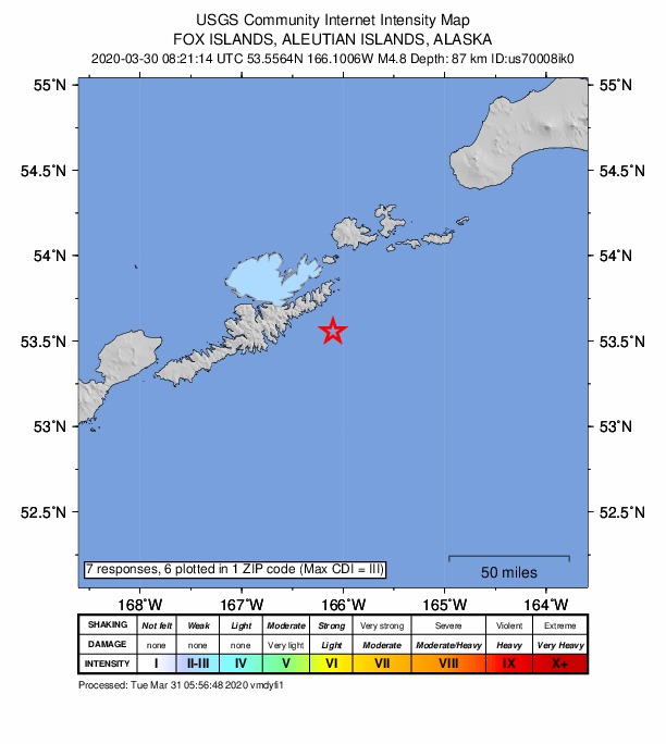
A magnitude 4.8 earthquake struck 35 km SE of Unalaska, Alaska on Mon, Mar 30, 2020, 12:21 AM AKDT (08:21 UTC), 87 km (54 mi) below the surface.
Map
Where this earthquake was located, with the others nearby. Select one for its page.
The earthquake
- Magnitude
- 4.8 (mww), light
- Local time
- UTC
- 2020-03-30 08:21:15 UTC
- Depth
- 86.9 km (54.0 mi), intermediate-depth
- Epicenter
- 53.625° N, 166.206° W
- Region
- Alaska
- Felt reports
- 6
- Tsunami flag
- No
- Status
- Reviewed by a seismologist
Did you feel it?
6 people reported to the USGS what they felt; the strongest reported shaking was III, weak shaking.
Fault motion and ground failure
How the rock slipped, from the moment tensor, and the USGS estimate of landslides and liquefaction.
- Faulting
- Oblique reverse
- Moment magnitude
- 4.8 Mww
- Nodal plane 1
- Strike 141°, dip 46°, rake 36°
- Nodal plane 2
- Strike 24°, dip 65°, rake 130°
How well it is located
Reviewed by a seismologist.
- Location uncertainty
- About 5.6 km horizontally, 3.9 km in depth
- Magnitude uncertainty
- ±0.07
- Depth from
- From location
- Station coverage gap
- 81°
- Stations used
- 200
Nearest places
Distance and direction from each place to the epicenter, with its forecast.
Nearby
Within 100 km, magnitude 1.8 and up: 41 in the 60 days after this one and 19 in the 30 days before it.
After
- 1.971 km SE of Unalaska, Alaska · 2374 days ago · 29 km deep · 37 km away
- 2.845 km SE of Unalaska, Alaska · 2371 days ago · 44 km deep · 11 km away
- 2.26 km WSW of Unalaska, Alaska · 2369 days ago · 99 km deep · 37 km away
- 1.877 km SSE of Akutan, Alaska · 2368 days ago · 23 km deep · 71 km away
- 3.273 km SW of Unalaska, Alaska · 2366 days ago · 8 km deep · 81 km away
- 2.1Fox Islands, Aleutian Islands, Alaska · 2366 days ago · 7 km deep · 62 km away
- 2.1Fox Islands, Aleutian Islands, Alaska · 2366 days ago · 72 km deep · 43 km away
- 1.879 km S of Unalaska, Alaska · 2365 days ago · 20 km deep · 57 km away
- 3.581 km SW of Unalaska, Alaska · 2363 days ago · 70 km deep · 81 km away
- 1.9114 km SSW of Unalaska, Alaska · 2362 days ago · 26 km deep · 99 km away
- 2.979 km SE of Unalaska, Alaska · 2360 days ago · 24 km deep · 44 km away
- 2.181 km SSW of Unalaska, Alaska · 2358 days ago · 33 km deep · 67 km away
- 4.427 km S of Unalaska, Alaska · 2358 days ago · 75 km deep · 17 km away
- 1.925 km S of Unalaska, Alaska · 2353 days ago · 80 km deep · 26 km away
- 1.885 km SSW of Unalaska, Alaska · 2352 days ago · 36 km deep · 73 km away
- 1.928 km E of Unalaska, Alaska · 2350 days ago · 77 km deep · 32 km away
- 3.1Fox Islands, Aleutian Islands, Alaska · 2348 days ago · 7 km deep · 97 km away
- 3.759 km S of Unalaska, Alaska · 2347 days ago · 95 km deep · 36 km away
- 1.849 km S of Akutan, Alaska · 2344 days ago · 50 km deep · 39 km away
- 2.785 km SSW of Unalaska, Alaska · 2344 days ago · 35 km deep · 70 km away
- 2.181 km SSW of Unalaska, Alaska · 2341 days ago · 45 km deep · 68 km away
- 3.792 km SE of Akutan, Alaska · 2339 days ago · 27 km deep · 99 km away
- 1.999 km SE of Akutan, Alaska · 2337 days ago · 26 km deep · 90 km away
- 1.9Fox Islands, Aleutian Islands, Alaska · 2332 days ago · 26 km deep · 66 km away
- 1.833 km SSE of Akutan, Alaska · 2332 days ago · 62 km deep · 44 km away
- 2.228 km SW of Unalaska, Alaska · 2331 days ago · 112 km deep · 46 km away
- 2.080 km SSW of Unalaska, Alaska · 2330 days ago · 78 km deep · 77 km away
- 1.864 km SE of Unalaska, Alaska · 2329 days ago · 52 km deep · 29 km away
- 1.887 km SSE of Akutan, Alaska · 2329 days ago · 25 km deep · 73 km away
- 2.886 km SSE of Unalaska, Alaska · 2328 days ago · 35 km deep · 55 km away
- 2.539 km SE of Unalaska, Alaska · 2328 days ago · 39 km deep · 5 km away
- 1.877 km SE of Akutan, Alaska · 2327 days ago · 58 km deep · 76 km away
- 2.0100 km S of Unalaska, Alaska · 2326 days ago · 3 km deep · 79 km away
- 2.234 km N of Akutan, Alaska · 2325 days ago · 111 km deep · 93 km away
- 2.962 km SE of Akutan, Alaska · 2323 days ago · 35 km deep · 65 km away
- 1.837 km SE of Akutan, Alaska · 2321 days ago · 73 km deep · 65 km away
- 2.524 km SE of Unalaska, Alaska · 2321 days ago · 75 km deep · 11 km away
- 1.982 km SE of Akutan, Alaska · 2318 days ago · 67 km deep · 81 km away
- 2.812 km W of Akutan, Alaska · 2317 days ago · 10 km deep · 60 km away
- 2.143 km SE of Akutan, Alaska · 2317 days ago · 57 km deep · 57 km away
- 2.918 km N of Dutch Harbor, Alaska · 2315 days ago · 138 km deep · 53 km away
Before
- 2.962 km SW of Unalaska, Alaska · 2375 days ago · 10 km deep · 63 km away
- 2.851 km S of Akutan, Alaska · 2376 days ago · 71 km deep · 32 km away
- 2.047 km SE of Unalaska, Alaska · 2376 days ago · 60 km deep · 12 km away
- 2.132 km S of Akutan, Alaska · 2377 days ago · 63 km deep · 34 km away
- 2.531 km SE of Unalaska, Alaska · 2377 days ago · 79 km deep · 7 km away
- 2.985 km SSE of Akutan, Alaska · 2380 days ago · 35 km deep · 66 km away
- 2.182 km SSE of Akutan, Alaska · 2381 days ago · 19 km deep · 64 km away
- 1.884 km S of Unalaska, Alaska · 2382 days ago · 19 km deep · 63 km away
- 3.864 km SE of Akutan, Alaska · 2386 days ago · 35 km deep · 71 km away · felt by 1
- 1.951 km SW of Unalaska, Alaska · 2388 days ago · 13 km deep · 61 km away
- 2.375 km SSE of Akutan, Alaska · 2389 days ago · 23 km deep · 58 km away
- 4.176 km SSE of Akutan, Alaska · 2390 days ago · 46 km deep · 58 km away
- 2.976 km S of Unalaska, Alaska · 2392 days ago · 35 km deep · 58 km away
- 2.576 km SE of Unalaska, Alaska · 2395 days ago · 35 km deep · 42 km away
- 2.6Unimak Island region, Alaska · 2398 days ago · 35 km deep · 90 km away
- 2.153 km SW of Unalaska, Alaska · 2399 days ago · 16 km deep · 63 km away
- 2.230 km ENE of Unalaska, Alaska · 2400 days ago · 79 km deep · 35 km away
- 2.035 km ESE of Unalaska, Alaska · 2402 days ago · 78 km deep · 23 km away
- 3.668 km SE of Unalaska, Alaska · 2405 days ago · 35 km deep · 33 km away
Earthquakes todayAlaska earthquakesLive radar here
Sources
From the USGS Earthquake Hazards Program and its partner networks, event us70008ik0 (also filed as ak02044z98gt). Read Wed, Sep 30, 2026, 9:11 AM UTC.