M2.5 earthquake 37km E of Three Rivers, CA
A magnitude 2.5 earthquake struck 37km E of Three Rivers, CA on Fri, Jan 31, 2020, 6:13 PM PST (02:13 UTC), 15 km (9 mi) below the surface.
Automatic solution: the magnitude and location may still be revised.
A larger quake followed: M3.8 11km NE of Coso Junction, CA. This one was a foreshock.
Map
Where this earthquake was located, with the others nearby. Select one for its page.
The earthquake
- Magnitude
- 2.5 (ML, local (Richter)), micro
- Magnitude from
- Southern California Seismic Network
- Local time
- UTC
- 2020-02-01 02:13:42 UTC
- Depth
- 15.2 km (9.5 mi), shallow
- Epicenter
- 36.452° N, 118.487° W
- Region
- California
- Felt reports
- 1
- Tsunami flag
- No
- Status
- Automatic solution, may be revised
Did you feel it?
1 person reported to the USGS what they felt; the strongest reported shaking was I, not felt shaking.
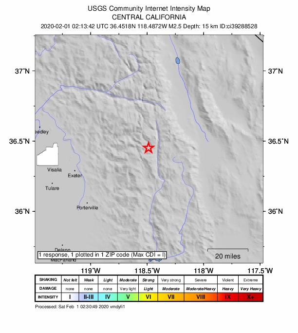
How well it is located
An automatic solution; a seismologist may revise it.
- Location uncertainty
- About 1.4 km horizontally, 15.3 km in depth
- Magnitude uncertainty
- ±0.45
- Depth from
- Operator assigned
- Station coverage gap
- 178°
- Stations used
- 11
Nearest places
Distance and direction from each place to the epicenter, with its forecast.
Nearby
Within 100 km, magnitude 1.5 and up: 160 in the 60 days after this one and 75 in the 30 days before it.
After
- 2.420km ESE of Little Lake, CA · 2438 days ago · 8 km deep · 95 km away · felt by 2
- 1.512km NNE of Coso Junction, CA · 2437 days ago · 4 km deep · 61 km away
- 1.723 km ESE of Little Lake, CA · 2436 days ago · 8 km deep · 99 km away
- 1.912 km NNE of Coso Junction, CA · 2436 days ago · 2 km deep · 64 km away
- 1.620 km E of Little Lake, CA · 2435 days ago · 9 km deep · 94 km away
- 1.614km NE of Coso Junction, CA · 2434 days ago · 5 km deep · 66 km away
- 1.614km NE of Coso Junction, CA · 2434 days ago · 5 km deep · 66 km away
- 1.523 km ESE of Little Lake, CA · 2434 days ago · 6 km deep · 99 km away
- 2.09 km ENE of Coso Junction, CA · 2433 days ago · 6 km deep · 69 km away
- 2.011 km NE of Coso Junction, CA · 2432 days ago · 3 km deep · 68 km away
- 1.614km N of Lone Pine, CA · 2431 days ago · 7 km deep · 48 km away
- 1.721km ESE of Little Lake, CA · 2430 days ago · 5 km deep · 96 km away
- 2.220 km ESE of Little Lake, CA · 2430 days ago · 7 km deep · 96 km away
- 1.713km SSW of Olancha, CA · 2430 days ago · 2 km deep · 48 km away
- 1.512km SSW of Olancha, CA · 2430 days ago · 1 km deep · 48 km away
- 1.613km N of Coso Junction, CA · 2429 days ago · 4 km deep · 60 km away
- 1.712km NE of Coso Junction, CA · 2428 days ago · 2 km deep · 68 km away
- 1.721 km ESE of Little Lake, CA · 2428 days ago · 8 km deep · 97 km away
- 2.014km N of Lone Pine, CA · 2428 days ago · 2 km deep · 48 km away
- 2.411km WSW of Squaw Valley, CA · 2428 days ago · 24 km deep · 84 km away
- 2.210km WSW of Squaw Valley, CA · 2427 days ago · 22 km deep · 83 km away
- 1.89km ENE of Coso Junction, CA · 2427 days ago · 2 km deep · 71 km away
- 1.621 km ESE of Little Lake, CA · 2427 days ago · 10 km deep · 97 km away
- 1.718 km ESE of Little Lake, CA · 2425 days ago · 5 km deep · 94 km away
- 1.923 km ESE of Little Lake, CA · 2425 days ago · 8 km deep · 99 km away
- 1.522km ESE of Little Lake, CA · 2422 days ago · 8 km deep · 97 km away
- 1.822 km ESE of Little Lake, CA · 2421 days ago · 8 km deep · 98 km away
- 2.316 km ESE of Little Lake, CA · 2420 days ago · 4 km deep · 92 km away
- 3.114km SW of Olancha, CA · 2420 days ago · 2 km deep · 42 km away · felt by 5
- 2.114km SW of Olancha, CA · 2420 days ago · 3 km deep · 42 km away
- 2.114km SW of Olancha, CA · 2420 days ago · 2 km deep · 42 km away
- 1.620 km E of Little Lake, CA · 2420 days ago · 9 km deep · 93 km away
- 3.36km E of Independence, CA · 2420 days ago · 4 km deep · 50 km away · felt by 7
- 2.514km SW of Olancha, CA · 2420 days ago · 2 km deep · 42 km away
- 1.814km SW of Olancha, CA · 2420 days ago · 3 km deep · 42 km away
- 1.614km SW of Olancha, CA · 2420 days ago · 3 km deep · 42 km away
- 2.322 km ESE of Little Lake, CA · 2420 days ago · 8 km deep · 97 km away
- 2.414km SW of Olancha, CA · 2420 days ago · 2 km deep · 42 km away
- 1.612km NNE of Coso Junction, CA · 2419 days ago · 2 km deep · 64 km away
- 2.818km E of Little Lake, CA · 2419 days ago · 4 km deep · 91 km away
- 1.518 km E of Little Lake, CA · 2418 days ago · 5 km deep · 91 km away
- 1.622km ESE of Little Lake, CA · 2417 days ago · 7 km deep · 97 km away
- 1.714km NE of Coso Junction, CA · 2417 days ago · 1 km deep · 66 km away
- 1.721km E of Little Lake, CA · 2417 days ago · 3 km deep · 94 km away
- 2.013 km NE of Coso Junction, CA · 2416 days ago · 2 km deep · 67 km away
- 1.612 km NE of Coso Junction, CA · 2416 days ago · 4 km deep · 67 km away
- 1.916 km E of Little Lake, CA · 2415 days ago · 4 km deep · 91 km away
- 2.321km E of Little Lake, CA · 2414 days ago · 3 km deep · 94 km away
- 2.121 km E of Little Lake, CA · 2414 days ago · 4 km deep · 95 km away
- 2.521km E of Little Lake, CA · 2414 days ago · 3 km deep · 94 km away
- 1.721km E of Little Lake, CA · 2414 days ago · 2 km deep · 94 km away
- 1.52km SSW of Bishop, CA · 2414 days ago · 8 km deep · 100 km away
- 1.89 km ENE of Coso Junction, CA · 2413 days ago · 3 km deep · 71 km away
- 1.810 km NE of Coso Junction, CA · 2413 days ago · 2 km deep · 66 km away
- 2.09 km ENE of Coso Junction, CA · 2413 days ago · 2 km deep · 71 km away
- 2.419km S of Big Pine, CA · 2413 days ago · 5 km deep · 62 km away
- 1.917 km NE of Olancha, CA · 2413 days ago · 1 km deep · 56 km away
- 1.813km NE of Coso Junction, CA · 2413 days ago · 2 km deep · 69 km away
- 1.810 km ENE of Coso Junction, CA · 2412 days ago · 2 km deep · 69 km away
- 1.720 km E of Little Lake, CA · 2411 days ago · 4 km deep · 94 km away
The first 60 of 160.
Before
- 1.79km NE of Coso Junction, CA · 2438 days ago · 3 km deep · 68 km away
- 1.88km E of Coso Junction, CA · 2438 days ago · 3 km deep · 72 km away
- 2.38 km E of Coso Junction, CA · 2438 days ago · 3 km deep · 72 km away
- 2.17km SSE of Shaver Lake, CA · 2439 days ago · 40 km deep · 96 km away
- 1.82 km S of Lone Pine, CA · 2439 days ago · 9 km deep · 39 km away
- 1.72km SSW of Lone Pine, CA · 2439 days ago · 9 km deep · 39 km away
- 2.322 km ESE of Little Lake, CA · 2440 days ago · 7 km deep · 97 km away
- 1.612 km ENE of Coso Junction, CA · 2440 days ago · 2 km deep · 71 km away
- 1.923 km E of Little Lake, CA · 2440 days ago · 3 km deep · 93 km away
- 1.524 km ESE of Little Lake, CA · 2441 days ago · 8 km deep · 99 km away
- 2.616km ESE of Little Lake, CA · 2442 days ago · 8 km deep · 91 km away
- 1.512 km ENE of Coso Junction, CA · 2442 days ago · 1 km deep · 71 km away
- 1.617 km ESE of Little Lake, CA · 2442 days ago · 5 km deep · 93 km away
- 1.67km SSW of Coso Junction, CA · 2442 days ago · 6 km deep · 68 km away
- 1.618 km ESE of Little Lake, CA · 2443 days ago · 5 km deep · 93 km away
- 2.012 km ENE of Coso Junction, CA · 2443 days ago · 2 km deep · 71 km away
- 2.119 km ESE of Little Lake, CA · 2444 days ago · 8 km deep · 94 km away
- 1.617 km ESE of Little Lake, CA · 2445 days ago · 5 km deep · 93 km away
- 2.224 km ESE of Little Lake, CA · 2446 days ago · 7 km deep · 99 km away
- 1.920 km E of Little Lake, CA · 2446 days ago · 4 km deep · 93 km away
Earthquakes todayCalifornia earthquakesLive radar here
Sources
From the USGS Earthquake Hazards Program and its partner networks, event ci39288528. Read Mon, Oct 5, 2026, 3:50 AM UTC.