M5.6 earthquake 44 km SSE of Sand Point, Alaska
A magnitude 5.6 earthquake struck 44 km SSE of Sand Point, Alaska on Wed, Jul 29, 2020, 1:12 AM AKDT (09:12 UTC), 39 km (24 mi) below the surface.
Map
Where this earthquake was located, with the others nearby. Select one for its page.
The earthquake
- Magnitude
- 5.6 (mww), moderate
- Local time
- UTC
- 2020-07-29 09:12:16 UTC
- Depth
- 39.0 km (24.2 mi), shallow
- Epicenter
- 54.944° N, 160.330° W
- Region
- Alaska
- Felt reports
- 6
- Strongest shaking
- IV, light shaking
- PAGER alert
- Green
- Tsunami flag
- Yes: a large quake in an oceanic region
- Status
- Reviewed by a seismologist
Tsunami
The USGS flags a quake this large in an oceanic region. The flag does not mean a tsunami happened; the tsunami warning centers decide that, and their messages are below when they issued any.
Current tsunami warnings: tsunami.gov. Warnings in force in the US also appear on our alerts pages.
Shaking
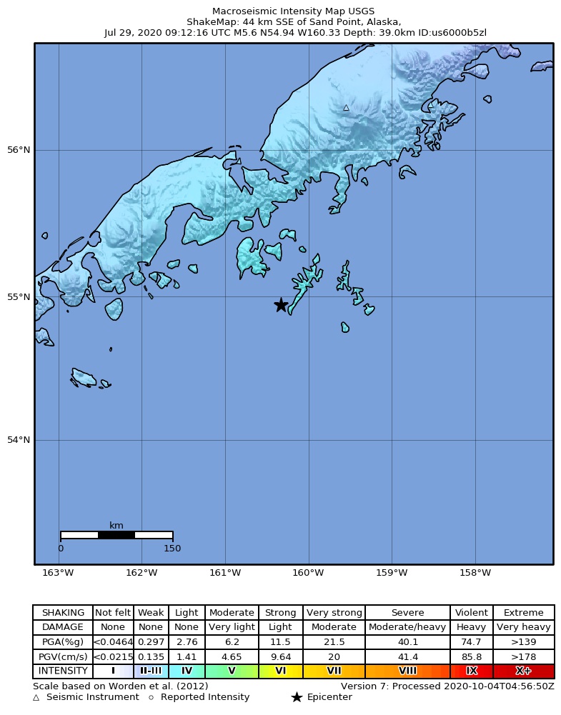
The USGS ShakeMap: shaking estimated from seismic stations and the quake’s size, on the Modified Mercalli intensity scale.
- Strongest estimated
- IV, light shaking
- Peak ground acceleration
- 4.8% of gravity
- Peak ground velocity
- 0.8 cm/s
- Map
- Automatic
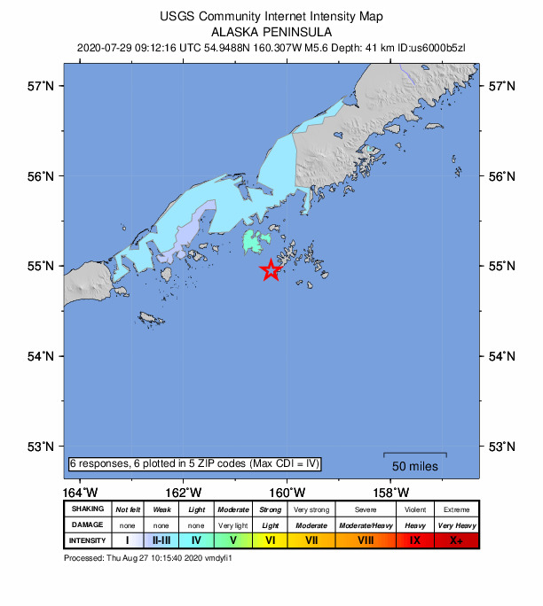
Did you feel it?
6 people reported to the USGS what they felt; the strongest reported shaking was IV, light shaking.
Estimated impact
The USGS PAGER system estimates deaths and economic losses from the shaking and the population and buildings exposed to it.
- Alert level
- Green: little or no damage or loss of life expected
| Range | Chance |
|---|---|
| Under 1 | 69% |
| 1 to 10 | 29% |
| 10 to 100 | 2% |
| 100 to 1,000 | Under 1% |
| 1,000 to 10,000 | Under 1% |
| 10,000 to 100,000 | Under 1% |
| 100,000 to 10,000,000 | Under 1% |
| Range, million USD | Chance |
|---|---|
| Under 1 | 65% |
| 1 to 10 | 30% |
| 10 to 100 | 4% |
| 100 to 1,000 | Under 1% |
| 1,000 to 10,000 | Under 1% |
| 10,000 to 100,000 | Under 1% |
| 100,000 to 10,000,000 | Under 1% |
Fault motion and ground failure
How the rock slipped, from the moment tensor, and the USGS estimate of landslides and liquefaction.
- Faulting
- Reverse (thrust)
- Moment magnitude
- 5.6 Mww
- Nodal plane 1
- Strike 254°, dip 31°, rake 102°
- Nodal plane 2
- Strike 60°, dip 60°, rake 83°
- Landslide alert
- Green
- Liquefaction alert
- Green
How well it is located
Reviewed by a seismologist.
- Location uncertainty
- About 4.4 km horizontally, 1.8 km in depth
- Magnitude uncertainty
- ±0.03
- Depth from
- From modeling of broad-band P waveforms
- Station coverage gap
- 74°
- Stations used
- 557
Nearest places
Distance and direction from each place to the epicenter, with its forecast.
Nearby
Within 100 km, magnitude 2.6 and up: 165 in the 60 days after this one and at least 200 in the 30 days before it.
After
- 2.654 km SSE of Sand Point, Alaska · 2255 days ago · 30 km deep · 10 km away
- 3.245 km SSE of Sand Point, Alaska · 2255 days ago · 32 km deep · 4 km away
- 3.0121 km ESE of Sand Point, Alaska · 2255 days ago · 20 km deep · 96 km away
- 4.882 km SSW of Sand Point, Alaska · 2255 days ago · 38 km deep · 56 km away
- 3.050 km SSE of Sand Point, Alaska · 2255 days ago · 29 km deep · 6 km away
- 3.849 km SSE of Sand Point, Alaska · 2255 days ago · 42 km deep · 5 km away
- 2.880 km SSW of Sand Point, Alaska · 2254 days ago · 29 km deep · 53 km away
- 2.654 km SSE of Sand Point, Alaska · 2254 days ago · 28 km deep · 9 km away
- 3.051 km SSE of Sand Point, Alaska · 2254 days ago · 35 km deep · 7 km away
- 3.3102 km SSW of Sand Point, Alaska · 2254 days ago · 35 km deep · 66 km away
- 2.950 km S of Sand Point, Alaska · 2254 days ago · 25 km deep · 6 km away
- 3.486 km SSW of Sand Point, Alaska · 2254 days ago · 44 km deep · 56 km away
- 3.582 km SSW of Sand Point, Alaska · 2254 days ago · 47 km deep · 58 km away
- 3.687 km SSW of Sand Point, Alaska · 2254 days ago · 44 km deep · 56 km away
- 2.758 km S of Sand Point, Alaska · 2253 days ago · 26 km deep · 14 km away
- 3.081 km SSW of Sand Point, Alaska · 2252 days ago · 31 km deep · 59 km away
- 3.283 km SSW of Sand Point, Alaska · 2252 days ago · 23 km deep · 52 km away
- 4.2116 km SSW of Sand Point, Alaska · 2252 days ago · 25 km deep · 81 km away
- 2.9116 km SE of King Cove, Alaska · 2252 days ago · 8 km deep · 82 km away
- 3.383 km SSW of Sand Point, Alaska · 2252 days ago · 42 km deep · 51 km away
- 2.754 km SSE of Sand Point, Alaska · 2252 days ago · 35 km deep · 10 km away
- 4.162 km SE of Sand Point, Alaska · 2252 days ago · 44 km deep · 31 km away
- 3.2118 km SSW of Sand Point, Alaska · 2252 days ago · 4 km deep · 81 km away
- 2.682 km SE of Sand Point, Alaska · 2252 days ago · 28 km deep · 54 km away
- 4.763 km S of Sand Point, Alaska · 2252 days ago · 39 km deep · 20 km away · felt by 1
- 2.765 km SSE of Sand Point, Alaska · 2252 days ago · 25 km deep · 23 km away
- 3.255 km SSE of Sand Point, Alaska · 2251 days ago · 28 km deep · 10 km away
- 3.595 km ESE of Sand Point, Alaska · 2251 days ago · 29 km deep · 75 km away
- 2.855 km ESE of Sand Point, Alaska · 2251 days ago · 39 km deep · 49 km away
- 3.077 km SSW of Sand Point, Alaska · 2251 days ago · 29 km deep · 57 km away
- 2.7109 km SE of King Cove, Alaska · 2251 days ago · 17 km deep · 98 km away
- 4.889 km SSW of Sand Point, Alaska · 2250 days ago · 31 km deep · 57 km away
- 3.954 km SSE of Sand Point, Alaska · 2250 days ago · 33 km deep · 9 km away · felt by 2
- 3.867 km ESE of Sand Point, Alaska · 2250 days ago · 39 km deep · 59 km away
- 2.790 km SSW of Sand Point, Alaska · 2250 days ago · 10 km deep · 57 km away
- 3.064 km SSE of Sand Point, Alaska · 2250 days ago · 26 km deep · 23 km away
- 2.967 km S of Sand Point, Alaska · 2250 days ago · 18 km deep · 22 km away
- 2.664 km ESE of Sand Point, Alaska · 2249 days ago · 32 km deep · 54 km away
- 3.558 km SSE of Sand Point, Alaska · 2249 days ago · 37 km deep · 14 km away
- 2.8111 km SSW of Sand Point, Alaska · 2249 days ago · 8 km deep · 76 km away
- 2.860 km S of Sand Point, Alaska · 2249 days ago · 25 km deep · 16 km away
- 5.279 km SSW of Sand Point, Alaska · 2249 days ago · 35 km deep · 57 km away · felt by 2
- 2.691 km SE of King Cove, Alaska · 2249 days ago · 26 km deep · 65 km away
- 2.888 km ESE of King Cove, Alaska · 2248 days ago · 27 km deep · 64 km away
- 2.7103 km SE of Sand Point, Alaska · 2248 days ago · 31 km deep · 73 km away
- 2.6108 km SSW of Sand Point, Alaska · 2248 days ago · 19 km deep · 72 km away
- 3.488 km SE of King Cove, Alaska · 2248 days ago · 18 km deep · 70 km away
- 3.262 km SSE of Sand Point, Alaska · 2247 days ago · 36 km deep · 17 km away
- 3.7122 km S of Sand Point, Alaska · 2247 days ago · 15 km deep · 80 km away
- 5.194 km SSW of Sand Point, Alaska · 2247 days ago · 7 km deep · 65 km away · felt by 4 · tsunami flag
- 2.8114 km SE of King Cove, Alaska · 2247 days ago · 17 km deep · 84 km away
- 3.396 km SE of King Cove, Alaska · 2247 days ago · 35 km deep · 69 km away
- 4.055 km SSE of Sand Point, Alaska · 2247 days ago · 41 km deep · 11 km away
- 2.9108 km SE of King Cove, Alaska · 2247 days ago · 10 km deep · 80 km away
- 2.952 km S of Sand Point, Alaska · 2247 days ago · 28 km deep · 8 km away
- 2.9100 km SE of King Cove, Alaska · 2247 days ago · 6 km deep · 73 km away
- 2.994 km SE of King Cove, Alaska · 2247 days ago · 35 km deep · 68 km away
- 3.2120 km S of Sand Point, Alaska · 2247 days ago · 35 km deep · 77 km away
- 3.432 km SSE of Sand Point, Alaska · 2247 days ago · 17 km deep · 13 km away
- 3.2112 km S of Sand Point, Alaska · 2247 days ago · 28 km deep · 70 km away
The first 60 of 165.
Before
- 4.252 km SSE of Sand Point, Alaska · 2255 days ago · 41 km deep · 8 km away · felt by 1
- 2.651 km S of Sand Point, Alaska · 2255 days ago · 27 km deep · 8 km away
- 3.296 km SSW of Sand Point, Alaska · 2255 days ago · 7 km deep · 64 km away
- 2.9110 km SSW of Sand Point, Alaska · 2255 days ago · 13 km deep · 76 km away
- 2.852 km SSE of Sand Point, Alaska · 2255 days ago · 27 km deep · 8 km away
- 2.854 km SSE of Sand Point, Alaska · 2255 days ago · 25 km deep · 9 km away
- 4.077 km SSW of Sand Point, Alaska · 2255 days ago · 45 km deep · 54 km away
- 2.7115 km SSW of Sand Point, Alaska · 2255 days ago · 21 km deep · 78 km away
- 3.754 km SSE of Sand Point, Alaska · 2255 days ago · 45 km deep · 11 km away
- 3.551 km S of Sand Point, Alaska · 2255 days ago · 29 km deep · 8 km away
- 2.796 km SSW of Sand Point, Alaska · 2255 days ago · 10 km deep · 63 km away
- 2.650 km SSE of Sand Point, Alaska · 2255 days ago · 30 km deep · 6 km away
- 2.694 km SSW of Sand Point, Alaska · 2255 days ago · 20 km deep · 63 km away
- 4.058 km SSE of Sand Point, Alaska · 2256 days ago · 40 km deep · 13 km away
- 5.049 km SSE of Sand Point, Alaska · 2256 days ago · 42 km deep · 5 km away
- 2.783 km SSW of Sand Point, Alaska · 2256 days ago · 35 km deep · 55 km away
- 2.753 km SSE of Sand Point, Alaska · 2256 days ago · 26 km deep · 8 km away
- 4.354 km SSE of Sand Point, Alaska · 2256 days ago · 42 km deep · 9 km away
- 3.169 km ESE of Sand Point, Alaska · 2256 days ago · 35 km deep · 56 km away
- 3.377 km SSW of Sand Point, Alaska · 2256 days ago · 35 km deep · 51 km away · felt by 1
Earthquakes todayAlaska earthquakesLive radar here
Sources
From the USGS Earthquake Hazards Program and its partner networks, event us6000b5zl (also filed as at00qe848h, ak0209p3tqf3, iscgem618702374). Read Thu, Oct 1, 2026, 1:28 AM UTC.