M2.5 earthquake 32 km SE of Mina, Nevada
A magnitude 2.5 earthquake struck 32 km SE of Mina, Nevada on Sun, May 17, 2020, 4:53 AM PDT (11:53 UTC), 6 km (4 mi) below the surface.
A larger quake followed: M5.1 32 km ESE of Mina, Nevada. This one was a foreshock.
Map
Where this earthquake was located, with the others nearby. Select one for its page.
The earthquake
- Magnitude
- 2.5 (ML, local (Richter)), micro
- Magnitude from
- USGS National Earthquake Information Center
- Local time
- UTC
- 2020-05-17 11:53:24 UTC
- Depth
- 6.2 km (3.8 mi), shallow
- Epicenter
- 38.163° N, 117.874° W
- Region
- Nevada
- Strongest shaking
- III, weak shaking
- Tsunami flag
- No
- Status
- Reviewed by a seismologist
Shaking
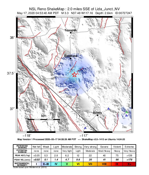
The USGS ShakeMap: shaking estimated from seismic stations and the quake’s size, on the Modified Mercalli intensity scale.
- Strongest estimated
- III, weak shaking
- Map
- Automatic
Did you feel it?
No one has reported feeling this quake to the USGS.
How well it is located
Reviewed by a seismologist.
- Location uncertainty
- About 1.0 km horizontally, 4.9 km in depth
- Magnitude uncertainty
- ±0.10
- Depth from
- From location
- Station coverage gap
- 61°
- Stations used
- 25
Nearest places
Distance and direction from each place to the epicenter, with its forecast.
Nearby
Within 100 km, magnitude 1.5 and up: at least 202 in the 60 days after this one and at least 200 in the 30 days before it.
After
- 4.529 km SSE of Mina, Nevada · 2329 days ago · 10 km deep · 7 km away · felt by 10
- 1.829 km SSE of Mina, Nevada · 2329 days ago · 11 km deep · 6 km away
- 2.029 km SE of Mina, Nevada · 2329 days ago · 6 km deep · 4 km away
- 2.0Nevada · 2329 days ago · 5 km deep · 10 km away
- 2.737 km SE of Mina, Nevada · 2329 days ago · 5 km deep · 9 km away
- 2.329 km SSE of Mina, Nevada · 2329 days ago · 13 km deep · 7 km away
- 2.127 km SSE of Mina, Nevada · 2329 days ago · 15 km deep · 14 km away
- 2.730 km N of Benton, California · 2329 days ago · 11 km deep · 57 km away
- 2.025 km SSE of Mina, Nevada · 2329 days ago · 1 km deep · 14 km away
- 1.825 km SSE of Mina, Nevada · 2329 days ago · 0 km deep · 12 km away
- 1.731 km SSE of Mina, Nevada · 2329 days ago · 13 km deep · 6 km away
- 2.337 km SE of Mina, Nevada · 2329 days ago · 0 km deep · 10 km away
- 3.027 km SSE of Mina, Nevada · 2329 days ago · 7 km deep · 13 km away
- 1.840 km SE of Mina, Nevada · 2329 days ago · 4 km deep · 12 km away
- 1.928 km S of Mina, Nevada · 2329 days ago · 1 km deep · 16 km away
- 2.033 km ESE of Mina, Nevada · 2329 days ago · 2 km deep · 12 km away
- 2.131 km SSE of Mina, Nevada · 2329 days ago · 7 km deep · 9 km away
- 1.938 km SE of Mina, Nevada · 2329 days ago · 8 km deep · 9 km away
- 2.330 km SE of Mina, Nevada · 2329 days ago · 6 km deep · 2 km away
- 1.928 km SSE of Mina, Nevada · 2329 days ago · 4 km deep · 6 km away
- 2.537 km SE of Mina, Nevada · 2329 days ago · 6 km deep · 8 km away
- 3.928 km SSE of Mina, Nevada · 2329 days ago · 11 km deep · 7 km away
- 2.035 km SE of Mina, Nevada · 2329 days ago · 2 km deep · 10 km away
- 1.833 km SE of Mina, Nevada · 2329 days ago · 4 km deep · 4 km away
- 1.931 km SE of Mina, Nevada · 2329 days ago · 9 km deep · 1 km away
- 2.031 km SE of Mina, Nevada · 2329 days ago · 6 km deep · 2 km away
- 1.629 km SE of Mina, Nevada · 2329 days ago · 4 km deep · 4 km away
- 2.029 km SE of Mina, Nevada · 2329 days ago · 4 km deep · 4 km away
- 2.039 km SE of Mina, Nevada · 2329 days ago · 8 km deep · 12 km away
- 1.533 km SE of Mina, Nevada · 2329 days ago · 5 km deep · 5 km away
- 2.333 km SE of Mina, Nevada · 2329 days ago · 7 km deep · 4 km away
- 2.138 km SE of Mina, Nevada · 2329 days ago · 5 km deep · 12 km away
- 2.537 km SE of Mina, Nevada · 2329 days ago · 7 km deep · 10 km away
- 2.429 km SSE of Mina, Nevada · 2329 days ago · 11 km deep · 5 km away
- 1.628 km S of Mina, Nevada · 2329 days ago · 1 km deep · 18 km away
- 1.527 km SSE of Mina, Nevada · 2329 days ago · 6 km deep · 10 km away
- 1.828 km SSE of Mina, Nevada · 2329 days ago · 5 km deep · 13 km away
- 2.132 km SE of Mina, Nevada · 2329 days ago · 12 km deep · 3 km away
- 1.739 km SE of Mina, Nevada · 2329 days ago · 5 km deep · 11 km away
- 1.927 km SE of Mina, Nevada · 2329 days ago · 9 km deep · 6 km away
- 2.626 km SE of Mina, Nevada · 2329 days ago · 6 km deep · 6 km away
- 1.732 km SE of Mina, Nevada · 2329 days ago · 6 km deep · 1 km away
- 2.731 km SE of Mina, Nevada · 2329 days ago · 11 km deep · 4 km away
- 1.834 km SE of Mina, Nevada · 2329 days ago · 0 km deep · 10 km away
- 1.931 km SSE of Mina, Nevada · 2329 days ago · 9 km deep · 9 km away
- 2.133 km SE of Mina, Nevada · 2329 days ago · 8 km deep · 5 km away
- 1.929 km SE of Mina, Nevada · 2329 days ago · 5 km deep · 4 km away
- 3.130 km N of Benton, California · 2329 days ago · 7 km deep · 58 km away
- 2.332 km SE of Mina, Nevada · 2329 days ago · 6 km deep · 2 km away
- 2.430 km S of Mina, Nevada · 2329 days ago · 7 km deep · 21 km away
- 2.032 km ESE of Mina, Nevada · 2329 days ago · 1 km deep · 12 km away
- 1.830 km S of Mina, Nevada · 2329 days ago · 1 km deep · 19 km away
- 1.532 km SE of Mina, Nevada · 2329 days ago · 1 km deep · 1 km away
- 2.432 km NNW of Benton, California · 2329 days ago · 0 km deep · 60 km away
- 1.737 km ESE of Mina, Nevada · 2329 days ago · 2 km deep · 13 km away
- 1.726 km S of Mina, Nevada · 2329 days ago · 1 km deep · 21 km away
- 1.631 km SE of Mina, Nevada · 2329 days ago · 1 km deep · 5 km away
- 2.828 km SSE of Mina, Nevada · 2329 days ago · 6 km deep · 10 km away
- 1.729 km SSE of Mina, Nevada · 2329 days ago · 2 km deep · 15 km away
- 1.629 km SSE of Mina, Nevada · 2329 days ago · 11 km deep · 7 km away
The first 60 of at least 202.
Before
- 1.829 km S of Mina, Nevada · 2329 days ago · 3 km deep · 16 km away
- 2.028 km S of Mina, Nevada · 2329 days ago · 0 km deep · 17 km away
- 1.632 km SE of Mina, Nevada · 2329 days ago · 1 km deep · 1 km away
- 2.934 km SE of Mina, Nevada · 2329 days ago · 3 km deep · 3 km away
- 1.932 km SE of Mina, Nevada · 2329 days ago · 3 km deep · 9 km away
- 1.627 km SE of Mina, Nevada · 2329 days ago · 0 km deep · 5 km away
- 3.735 km SE of Mina, Nevada · 2329 days ago · 12 km deep · 9 km away
- 2.328 km SSE of Mina, Nevada · 2329 days ago · 7 km deep · 8 km away
- 1.627 km SSE of Mina, Nevada · 2329 days ago · 6 km deep · 12 km away
- 2.331 km SE of Mina, Nevada · 2329 days ago · 1 km deep · 2 km away
- 1.730 km SE of Mina, Nevada · 2329 days ago · 13 km deep · 2 km away
- 2.032 km SE of Mina, Nevada · 2329 days ago · 5 km deep · 3 km away
- 1.5Nevada · 2329 days ago · 0 km deep · 1 km away
- 2.330 km SE of Mina, Nevada · 2329 days ago · 5 km deep · 4 km away
- 1.7Nevada · 2329 days ago · 2 km deep · 2 km away
- 2.028 km S of Mina, Nevada · 2329 days ago · 7 km deep · 16 km away
- 1.825 km S of Mina, Nevada · 2329 days ago · 2 km deep · 20 km away
- 2.730 km SSE of Mina, Nevada · 2329 days ago · 7 km deep · 7 km away
- 1.628 km SSE of Mina, Nevada · 2329 days ago · 10 km deep · 10 km away
- 1.935 km SE of Mina, Nevada · 2329 days ago · 0 km deep · 8 km away
Earthquakes todayNevada earthquakesLive radar here
Sources
From the USGS Earthquake Hazards Program and its partner networks, event us70009iv0 (also filed as nn00727247). Read Fri, Oct 2, 2026, 10:10 AM UTC.