M3.7 earthquake 49 km W of Mentone, Texas
A magnitude 3.7 earthquake struck 49 km W of Mentone, Texas on Wed, Oct 28, 2020, 9:07 AM CDT (14:07 UTC), 5 km (3 mi) below the surface.
Map
Where this earthquake was located, with the others nearby. Select one for its page.
The earthquake
- Magnitude
- 3.7 (mwr), minor
- Local time
- UTC
- 2020-10-28 14:07:37 UTC
- Depth
- 5.0 km (3.1 mi), shallow
- Epicenter
- 31.701° N, 104.124° W
- Region
- Texas
- Strongest shaking
- V, moderate shaking
- Tsunami flag
- No
- Status
- Reviewed by a seismologist
Shaking
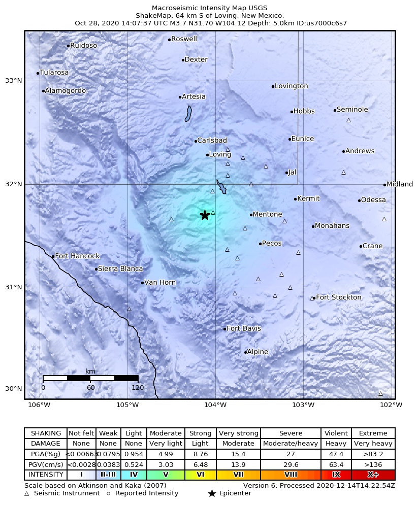
The USGS ShakeMap: shaking estimated from seismic stations and the quake’s size, on the Modified Mercalli intensity scale.
- Strongest estimated
- V, moderate shaking
- Peak ground acceleration
- 5.2% of gravity
- Peak ground velocity
- 0.1 cm/s
- Map
- Automatic
Did you feel it?
No one has reported feeling this quake to the USGS.
Fault motion and ground failure
How the rock slipped, from the moment tensor, and the USGS estimate of landslides and liquefaction.
- Faulting
- Normal
- Moment magnitude
- 3.7 Mwr
- Nodal plane 1
- Strike 99°, dip 50°, rake -118°
- Nodal plane 2
- Strike 318°, dip 48°, rake -61°
How well it is located
Reviewed by a seismologist.
- Location uncertainty
- About 1.4 km horizontally, 1.9 km in depth
- Magnitude uncertainty
- ±0.06
- Depth from
- Operator assigned
- Station coverage gap
- 49°
- Stations used
- 68
Nearest places
Distance and direction from each place to the epicenter, with its forecast.
Nearby
Within 100 km, magnitude 1.5 and up: 38 in the 60 days after this one and 18 in the 30 days before it.
After
- 3.656 km S of Whites City, New Mexico · 2162 days ago · 5 km deep · 19 km away · felt by 1
- 2.859 km S of Whites City, New Mexico · 2161 days ago · 5 km deep · 21 km away
- 2.957 km S of Whites City, New Mexico · 2161 days ago · 5 km deep · 18 km away
- 3.257 km S of Whites City, New Mexico · 2160 days ago · 5 km deep · 18 km away
- 2.859 km S of Whites City, New Mexico · 2160 days ago · 5 km deep · 20 km away
- 3.054 km NW of Toyah, Texas · 2159 days ago · 5 km deep · 16 km away
- 2.861 km S of Whites City, New Mexico · 2159 days ago · 5 km deep · 34 km away
- 2.846 km W of Mentone, Texas · 2159 days ago · 5 km deep · 4 km away
- 3.013 km SSE of Lindsay, Texas · 2157 days ago · 5 km deep · 78 km away
- 1.754 km NW of Toyah, Texas · 2156 days ago · 3 km deep · 14 km away
- 2.853 km NW of Toyah, Texas · 2156 days ago · 5 km deep · 16 km away
- 2.754 km NW of Toyah, Texas · 2156 days ago · 5 km deep · 15 km away · felt by 1
- 2.553 km SSW of Whites City, New Mexico · 2153 days ago · 5 km deep · 39 km away
- 2.725 km NNE of Mentone, Texas · 2151 days ago · 6 km deep · 66 km away
- 3.452 km SSW of Whites City, New Mexico · 2147 days ago · 8 km deep · 40 km away
- 2.546 km W of Mentone, Texas · 2145 days ago · 5 km deep · 4 km away
- 2.848 km W of Mentone, Texas · 2145 days ago · 5 km deep · 3 km away
- 3.347 km W of Mentone, Texas · 2144 days ago · 5 km deep · 4 km away
- 3.153 km S of Whites City, New Mexico · 2141 days ago · 11 km deep · 18 km away
- 2.449 km NW of Toyah, Texas · 2137 days ago · 5 km deep · 15 km away
- 1.79 km N of Barstow, Texas · 2135 days ago · 4 km deep · 73 km away
- 2.546 km NW of Toyah, Texas · 2134 days ago · 5 km deep · 16 km away
- 2.552 km S of Whites City, New Mexico · 2131 days ago · 7 km deep · 27 km away
- 2.755 km S of Whites City, New Mexico · 2129 days ago · 7 km deep · 30 km away
- 2.553 km NW of Toyah, Texas · 2127 days ago · 9 km deep · 9 km away
- 3.257 km S of Whites City, New Mexico · 2125 days ago · 10 km deep · 19 km away
- 2.552 km SSE of Whites City, New Mexico · 2125 days ago · 5 km deep · 6 km away
- 2.752 km S of Whites City, New Mexico · 2124 days ago · 5 km deep · 27 km away
- 2.858 km S of Whites City, New Mexico · 2123 days ago · 11 km deep · 18 km away
- 2.555 km S of Whites City, New Mexico · 2122 days ago · 10 km deep · 28 km away
- 2.858 km S of Whites City, New Mexico · 2118 days ago · 5 km deep · 17 km away
- 2.659 km S of Whites City, New Mexico · 2118 days ago · 5 km deep · 19 km away
- 2.558 km S of Whites City, New Mexico · 2115 days ago · 5 km deep · 24 km away
- 1.78 km N of Toyah, Texas · 2113 days ago · 6 km deep · 47 km away
- 2.758 km S of Whites City, New Mexico · 2112 days ago · 5 km deep · 18 km away
- 2.615 km WNW of Whites City, New Mexico · 2107 days ago · 3 km deep · 69 km away
- 2.554 km NW of Toyah, Texas · 2106 days ago · 5 km deep · 15 km away
- 2.656 km S of Whites City, New Mexico · 2106 days ago · 5 km deep · 24 km away
Before
- 2.858 km S of Whites City, New Mexico · 2163 days ago · 6 km deep · 16 km away
- 2.559 km S of Whites City, New Mexico · 2163 days ago · 5 km deep · 17 km away
- 2.749 km W of Mentone, Texas · 2163 days ago · 5 km deep · 1 km away
- 2.853 km S of Whites City, New Mexico · 2164 days ago · 5 km deep · 24 km away
- 2.942 km NW of Toyah, Texas · 2170 days ago · 5 km deep · 16 km away
- 2.556 km NW of Toyah, Texas · 2171 days ago · 5 km deep · 18 km away
- 2.857 km S of Whites City, New Mexico · 2173 days ago · 5 km deep · 18 km away
- 2.552 km W of Mentone, Texas · 2175 days ago · 5 km deep · 3 km away
- 3.048 km W of Mentone, Texas · 2176 days ago · 5 km deep · 6 km away
- 2.863 km S of Whites City, New Mexico · 2180 days ago · 5 km deep · 30 km away · felt by 1
- 2.5western Texas · 2181 days ago · 5 km deep · 26 km away
- 3.254 km SSW of Whites City, New Mexico · 2182 days ago · 5 km deep · 41 km away
- 3.053 km SSW of Whites City, New Mexico · 2182 days ago · 5 km deep · 42 km away
- 2.538 km W of Mentone, Texas · 2182 days ago · 5 km deep · 14 km away
- 2.654 km SSW of Whites City, New Mexico · 2183 days ago · 3 km deep · 42 km away
- 3.052 km SSW of Whites City, New Mexico · 2184 days ago · 5 km deep · 42 km away · felt by 2
- 2.551 km NW of Toyah, Texas · 2188 days ago · 5 km deep · 17 km away
- 3.056 km S of Whites City, New Mexico · 2189 days ago · 5 km deep · 22 km away · felt by 1
Earthquakes todayTexas earthquakesLive radar here
Sources
From the USGS Earthquake Hazards Program and its partner networks, event us7000c6s7. Read Wed, Sep 30, 2026, 2:46 AM UTC.