M3.5 earthquake 44 km W of Mentone, Texas
A magnitude 3.5 earthquake struck 44 km W of Mentone, Texas on Fri, Mar 27, 2020, 4:36 PM CDT (21:36 UTC), 6 km (4 mi) below the surface.
Map
Where this earthquake was located, with the others nearby. Select one for its page.
The earthquake
- Magnitude
- 3.5 (mwr), minor
- Local time
- UTC
- 2020-03-27 21:36:20 UTC
- Depth
- 5.8 km (3.6 mi), shallow
- Epicenter
- 31.697° N, 104.064° W
- Region
- Texas
- Strongest shaking
- IV, light shaking
- Tsunami flag
- No
- Status
- Reviewed by a seismologist
Shaking
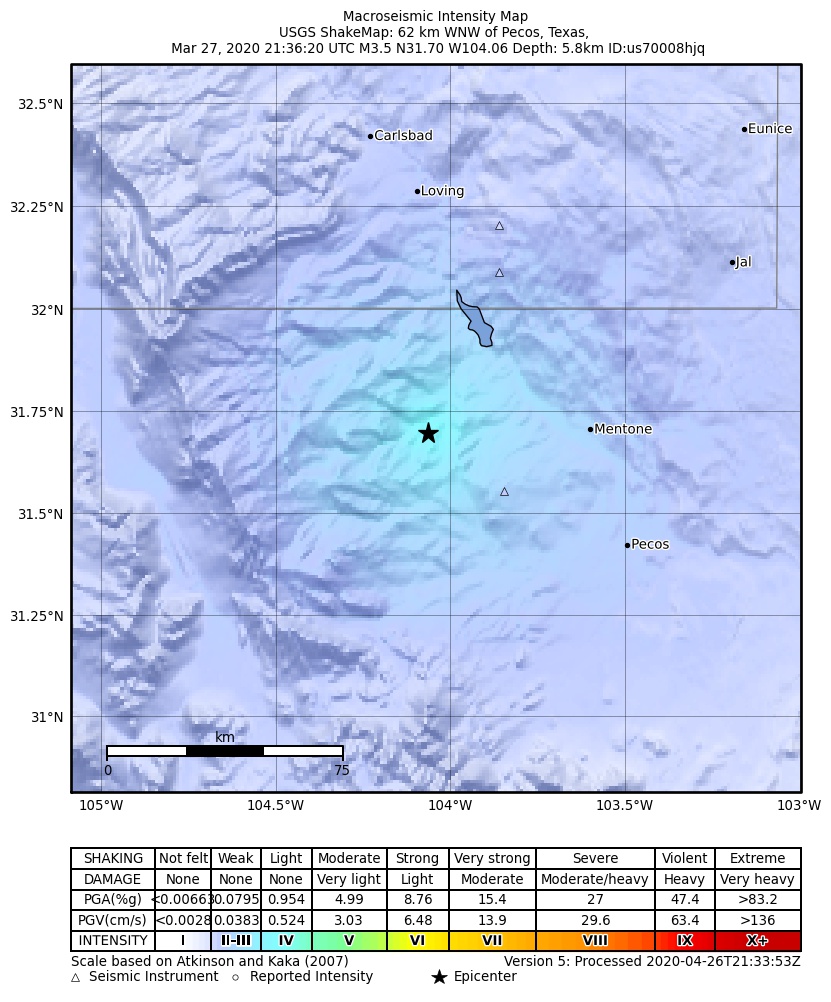
The USGS ShakeMap: shaking estimated from seismic stations and the quake’s size, on the Modified Mercalli intensity scale.
- Strongest estimated
- IV, light shaking
- Peak ground acceleration
- 2.6% of gravity
- Peak ground velocity
- -1.0 cm/s
- Map
- Automatic
Did you feel it?
No one has reported feeling this quake to the USGS.
Fault motion and ground failure
How the rock slipped, from the moment tensor, and the USGS estimate of landslides and liquefaction.
- Faulting
- Normal
- Moment magnitude
- 3.5 Mwr
- Nodal plane 1
- Strike 84°, dip 54°, rake -110°
- Nodal plane 2
- Strike 295°, dip 40°, rake -65°
How well it is located
Reviewed by a seismologist.
- Location uncertainty
- About 0.7 km horizontally, 4.9 km in depth
- Depth from
- From location
- Station coverage gap
- 50°
- Stations used
- 54
Nearest places
Distance and direction from each place to the epicenter, with its forecast.
Nearby
Within 100 km, magnitude 1.5 and up: 36 in the 60 days after this one and 23 in the 30 days before it.
After
- 3.142 km W of Mentone, Texas · 2377 days ago · 5 km deep · 2 km away · felt by 1
- 3.540 km W of Mentone, Texas · 2376 days ago · 5 km deep · 3 km away · felt by 2
- 2.953 km S of Whites City, New Mexico · 2372 days ago · 9 km deep · 36 km away · felt by 2
- 2.63 km ESE of Lindsay, Texas · 2371 days ago · 5 km deep · 65 km away
- 2.855 km S of Whites City, New Mexico · 2370 days ago · 5 km deep · 28 km away
- 2.753 km SSW of Whites City, New Mexico · 2370 days ago · 5 km deep · 46 km away
- 1.654 km S of Whites City, New Mexico · 2370 days ago · 6 km deep · 33 km away
- 3.456 km S of Whites City, New Mexico · 2362 days ago · 5 km deep · 30 km away · felt by 1
- 2.855 km S of Whites City, New Mexico · 2362 days ago · 5 km deep · 31 km away
- 2.9western Texas · 2361 days ago · 6 km deep · 46 km away · felt by 1
- 2.755 km S of Whites City, New Mexico · 2360 days ago · 5 km deep · 28 km away
- 3.140 km W of Mentone, Texas · 2360 days ago · 5 km deep · 4 km away
- 3.030 km SW of Coyanosa, Texas · 2358 days ago · 5 km deep · 98 km away · felt by 1
- 3.256 km S of Whites City, New Mexico · 2357 days ago · 5 km deep · 30 km away
- 2.558 km S of Whites City, New Mexico · 2356 days ago · 5 km deep · 29 km away · felt by 1
- 2.635 km SE of Malaga, New Mexico · 2351 days ago · 10 km deep · 48 km away
- 2.961 km SSW of Whites City, New Mexico · 2348 days ago · 5 km deep · 49 km away · felt by 1
- 3.356 km S of Whites City, New Mexico · 2344 days ago · 5 km deep · 32 km away · felt by 1
- 2.655 km S of Whites City, New Mexico · 2344 days ago · 5 km deep · 30 km away
- 2.758 km S of Whites City, New Mexico · 2343 days ago · 5 km deep · 32 km away
- 2.658 km S of Whites City, New Mexico · 2343 days ago · 5 km deep · 31 km away
- 2.556 km NW of Toyah, Texas · 2343 days ago · 5 km deep · 17 km away
- 2.656 km NW of Toyah, Texas · 2338 days ago · 5 km deep · 17 km away
- 3.154 km S of Whites City, New Mexico · 2337 days ago · 5 km deep · 30 km away
- 2.859 km S of Whites City, New Mexico · 2335 days ago · 5 km deep · 24 km away
- 3.257 km S of Whites City, New Mexico · 2332 days ago · 5 km deep · 25 km away
- 2.855 km S of Whites City, New Mexico · 2331 days ago · 8 km deep · 31 km away
- 3.558 km S of Whites City, New Mexico · 2331 days ago · 5 km deep · 24 km away · felt by 1
- 3.043 km W of Mentone, Texas · 2330 days ago · 5 km deep · 1 km away
- 2.519 km ESE of Lindsay, Texas · 2325 days ago · 6 km deep · 81 km away
- 3.056 km S of Whites City, New Mexico · 2322 days ago · 5 km deep · 31 km away · felt by 1
- 2.14 km E of Lindsay, Texas · 2322 days ago · 5 km deep · 65 km away · felt by 2
- 2.755 km S of Whites City, New Mexico · 2322 days ago · 5 km deep · 32 km away
- 2.956 km S of Whites City, New Mexico · 2322 days ago · 6 km deep · 26 km away
- 2.854 km S of Whites City, New Mexico · 2317 days ago · 5 km deep · 27 km away
- 3.055 km S of Whites City, New Mexico · 2317 days ago · 5 km deep · 34 km away
Before
- 2.740 km W of Mentone, Texas · 2377 days ago · 5 km deep · 4 km away
- 2.743 km W of Mentone, Texas · 2378 days ago · 2 km deep · 1 km away · felt by 2
- 3.140 km W of Mentone, Texas · 2378 days ago · 7 km deep · 3 km away · felt by 21
- 3.042 km W of Mentone, Texas · 2378 days ago · 5 km deep · 2 km away · felt by 6
- 3.241 km W of Mentone, Texas · 2378 days ago · 5 km deep · 4 km away · felt by 35
- 5.041 km W of Mentone, Texas · 2378 days ago · 10 km deep · 3 km away · felt by 1,468
- 1.642 km W of Mentone, Texas · 2379 days ago · 6 km deep · 2 km away
- 1.541 km W of Mentone, Texas · 2379 days ago · 9 km deep · 2 km away
- 1.741 km W of Mentone, Texas · 2379 days ago · 7 km deep · 3 km away
- 3.840 km W of Mentone, Texas · 2379 days ago · 5 km deep · 4 km away · felt by 23
- 3.032 km WSW of Coyanosa, Texas · 2381 days ago · 5 km deep · 94 km away
- 2.932 km WSW of Coyanosa, Texas · 2382 days ago · 5 km deep · 96 km away
- 2.736 km NNW of Toyah, Texas · 2383 days ago · 5 km deep · 13 km away
- 3.058 km S of Whites City, New Mexico · 2384 days ago · 5 km deep · 24 km away
- 2.658 km S of Whites City, New Mexico · 2385 days ago · 5 km deep · 24 km away
- 2.6western Texas · 2385 days ago · 5 km deep · 14 km away
- 2.857 km S of Whites City, New Mexico · 2386 days ago · 5 km deep · 29 km away · felt by 1
- 1.735 km NW of Toyah, Texas · 2389 days ago · 6 km deep · 19 km away
- 2.720 km WNW of Mentone, Texas · 2392 days ago · 5 km deep · 24 km away · felt by 2
- 2.864 km SSW of Whites City, New Mexico · 2392 days ago · 5 km deep · 52 km away
Earthquakes todayTexas earthquakesLive radar here
Sources
From the USGS Earthquake Hazards Program and its partner networks, event us70008hjq. Read Wed, Sep 30, 2026, 12:09 AM UTC.