M3.7 earthquake 62 km SSW of Lund, Nevada
A magnitude 3.7 earthquake struck 62 km SSW of Lund, Nevada on Fri, Apr 10, 2020, 7:39 PM PDT (02:39 UTC), 6 km (4 mi) below the surface.
Map
Where this earthquake was located, with the others nearby. Select one for its page.
The earthquake
- Magnitude
- 3.7 (ML, local (Richter)), minor
- Magnitude from
- Nevada Seismological Laboratory
- Local time
- UTC
- 2020-04-11 02:39:32 UTC
- Depth
- 6.3 km (3.9 mi), shallow
- Epicenter
- 38.328° N, 115.245° W
- Region
- Nevada
- Strongest shaking
- IV, light shaking
- Tsunami flag
- No
- Status
- Reviewed by a seismologist
Magnitude estimates
Different scales measure different things and differ by a few tenths. The USGS marks one as preferred, and it is the one this page uses.
| Mag. | Scale | Computed by | Notes |
|---|---|---|---|
| 3.7 | ML, local (Richter) | Nevada Seismological Laboratory | Preferred · Reviewed · ±0.15 · 7 stations |
| 3.3 | Mwr, regional moment | USGS National Earthquake Information Center | Reviewed · ±0.073 · 18 stations |
| 3.3 | Mwr, regional moment | Nevada Seismological Laboratory | Moment tensor · Reviewed |
Shaking
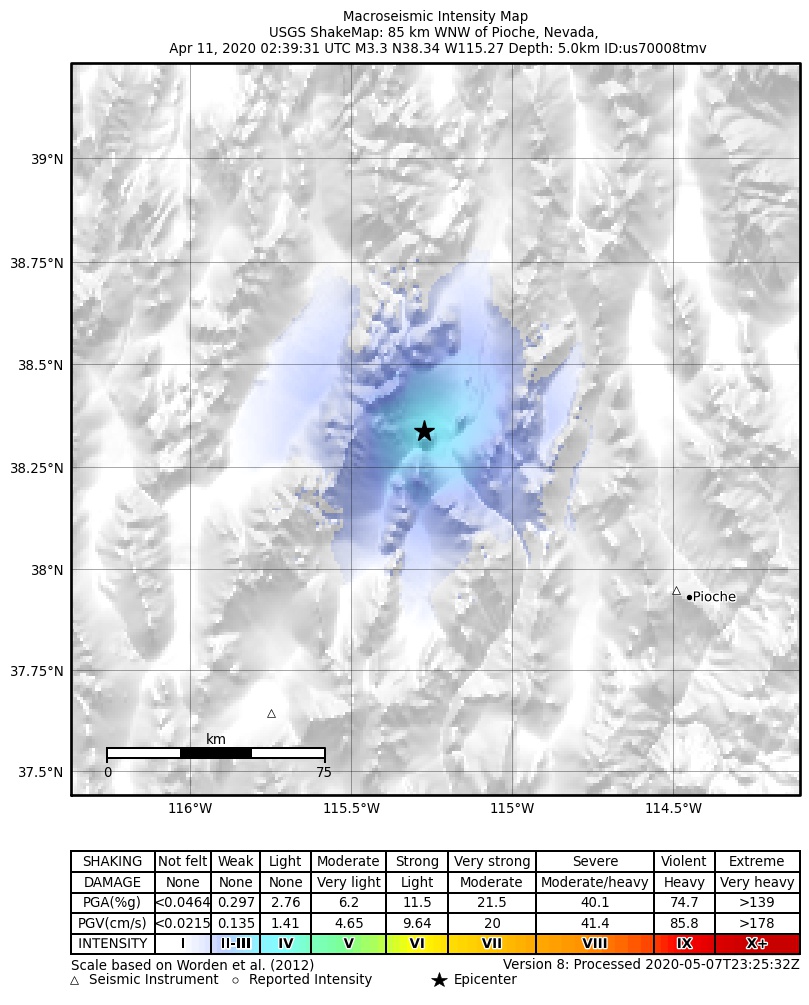
The USGS ShakeMap: shaking estimated from seismic stations and the quake’s size, on the Modified Mercalli intensity scale.
- Strongest estimated
- IV, light shaking
- Peak ground acceleration
- 2.3% of gravity
- Peak ground velocity
- -0.6 cm/s
- Map
- Automatic
Did you feel it?
No one has reported feeling this quake to the USGS.
Fault motion and ground failure
How the rock slipped, from the moment tensor, and the USGS estimate of landslides and liquefaction.
- Faulting
- Strike-slip
- Moment magnitude
- 3.3 Mwr
- Nodal plane 1
- Strike 116°, dip 62°, rake 25°
- Nodal plane 2
- Strike 14°, dip 68°, rake 150°
How well it is located
Reviewed by a seismologist.
- Magnitude uncertainty
- ±0.15
- Station coverage gap
- 79°
- Stations used
- 40
Nearest places
Distance and direction from each place to the epicenter, with its forecast.
Nearby
Within 100 km, magnitude 1.5 and up: 10 in the 60 days after this one and 11 in the 30 days before it.
After
- 1.663 km SSW of Lund, Nevada · 2364 days ago · 7 km deep · 1 km away
- 1.614 km NE of Alamo, Nevada · 2362 days ago · 5 km deep · 99 km away
- 1.563 km S of Lund, Nevada · 2357 days ago · 4 km deep · 18 km away
- 2.515 km NE of Alamo, Nevada · 2352 days ago · 12 km deep · 98 km away
- 1.758 km SSW of Lund, Nevada · 2347 days ago · 10 km deep · 4 km away
- 1.759 km SSW of Lund, Nevada · 2346 days ago · 9 km deep · 3 km away
- 2.744 km NW of Rachel, Nevada · 2345 days ago · 12 km deep · 94 km away
- 1.695 km WSW of Preston, Nevada · 2331 days ago · 7 km deep · 71 km away
- 1.765 km SSW of Lund, Nevada · 2331 days ago · 10 km deep · 7 km away
- 1.691 km ENE of Tonopah, Nevada · 2319 days ago · 8 km deep · 88 km away
Before
- 3.060 km SSW of Lund, Nevada · 2366 days ago · 6 km deep · 2 km away
- 1.576 km N of Rachel, Nevada · 2371 days ago · 7 km deep · 48 km away
- 1.978 km N of Rachel, Nevada · 2372 days ago · 6 km deep · 49 km away
- 2.514 km NE of Alamo, Nevada · 2372 days ago · 5 km deep · 99 km away
- 2.177 km N of Rachel, Nevada · 2373 days ago · 5 km deep · 50 km away
- 1.614 km NE of Alamo, Nevada · 2374 days ago · 0 km deep · 97 km away
- 1.714 km NE of Alamo, Nevada · 2375 days ago · 4 km deep · 99 km away
- 2.0Nevada · 2387 days ago · 9 km deep · 86 km away
- 2.076 km N of Rachel, Nevada · 2388 days ago · 7 km deep · 50 km away
- 1.815 km NE of Hiko, Nevada · 2390 days ago · 6 km deep · 71 km away
- 2.550 km N of Hiko, Nevada · 2393 days ago · 3 km deep · 31 km away
Earthquakes todayNevada earthquakesLive radar here
Sources
From the USGS Earthquake Hazards Program and its partner networks, event nn00721556 (also filed as us70008tmv). Read Fri, Oct 2, 2026, 1:43 PM UTC.