M3.0 earthquake 15 km SW of Lowell Point, Alaska
A magnitude 3.0 earthquake struck 15 km SW of Lowell Point, Alaska on Thu, Jul 23, 2020, 12:07 PM AKDT (20:07 UTC), 17 km (10 mi) below the surface.
A larger quake followed: M3.4 33 km WSW of Hope, Alaska. This one was a foreshock.
Map
Where this earthquake was located, with the others nearby. Select one for its page.
The earthquake
- Magnitude
- 3.0 (ML, local (Richter)), minor
- Magnitude from
- Alaska Earthquake Center
- Local time
- UTC
- 2020-07-23 20:07:35 UTC
- Depth
- 16.6 km (10.3 mi), shallow
- Epicenter
- 59.972° N, 149.639° W
- Region
- Alaska
- Felt reports
- 10
- Tsunami flag
- No
- Status
- Reviewed by a seismologist
Magnitude estimates
Different scales measure different things and differ by a few tenths. The USGS marks one as preferred, and it is the one this page uses.
| Mag. | Scale | Computed by | Notes |
|---|---|---|---|
| 3.0 | ML, local (Richter) | Alaska Earthquake Center | Preferred · Preliminary |
| 3.2 | ML, local (Richter) | USGS National Earthquake Information Center | Reviewed · ±0.027 · 176 stations |
What happened
The USGS’s account of the effects of this earthquake.
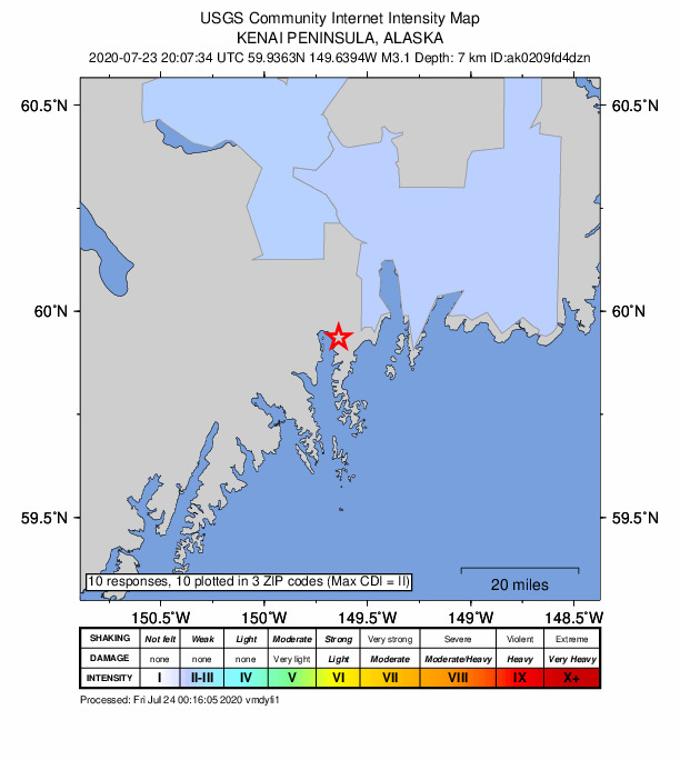
Felt lightly at Seward.
From the USGS event page for ak0209fd4dzn. U.S. Geological Survey text and figures are in the public domain.
Did you feel it?
10 people reported to the USGS what they felt; the strongest reported shaking was III, weak shaking.
How well it is located
Reviewed by a seismologist.
- Stations used
- 114
Nearest places
Distance and direction from each place to the epicenter, with its forecast.
Nearby
Within 100 km, magnitude 1.5 and up: 60 in the 60 days after this one and 31 in the 30 days before it.
After
- 3.018 km SW of Lowell Point, Alaska · 2261 days ago · 12 km deep · 4 km away · felt by 2
- 1.522 km NE of Sterling, Alaska · 2258 days ago · 45 km deep · 88 km away
- 1.711 km SE of Chenega, Alaska · 2257 days ago · 15 km deep · 99 km away
- 1.718 km ESE of Clam Gulch, Alaska · 2254 days ago · 68 km deep · 83 km away
- 2.123 km SSW of Funny River, Alaska · 2252 days ago · 61 km deep · 76 km away
- 1.942 km SSE of Funny River, Alaska · 2252 days ago · 36 km deep · 49 km away
- 2.53 km WSW of Funny River, Alaska · 2251 days ago · 47 km deep · 87 km away · felt by 2
- 1.620 km E of Fox River, Alaska · 2251 days ago · 38 km deep · 55 km away
- 1.521 km WSW of Cooper Landing, Alaska · 2250 days ago · 33 km deep · 59 km away
- 1.619 km SSW of Lowell Point, Alaska · 2250 days ago · 8 km deep · 6 km away
- 1.619 km SW of Lowell Point, Alaska · 2250 days ago · 7 km deep · 5 km away
- 2.223 km SE of Kasilof, Alaska · 2250 days ago · 62 km deep · 78 km away
- 1.830 km ESE of Point Possession, Alaska · 2249 days ago · 40 km deep · 97 km away
- 2.415 km ESE of Clam Gulch, Alaska · 2249 days ago · 65 km deep · 86 km away
- 2.38 km NW of Sterling, Alaska · 2249 days ago · 46 km deep · 97 km away
- 1.517 km ESE of Clam Gulch, Alaska · 2247 days ago · 40 km deep · 84 km away
- 2.125 km E of Fox River, Alaska · 2245 days ago · 27 km deep · 50 km away
- 1.720 km WNW of Bear Creek, Alaska · 2244 days ago · 46 km deep · 30 km away
- 1.57 km ENE of Sterling, Alaska · 2243 days ago · 10 km deep · 85 km away
- 2.218 km NNE of Sterling, Alaska · 2242 days ago · 48 km deep · 97 km away
- 1.714 km SW of Hope, Alaska · 2241 days ago · 45 km deep · 94 km away
- 1.61 km W of Fox River, Alaska · 2240 days ago · 43 km deep · 76 km away
- 2.028 km W of Seward, Alaska · 2240 days ago · 25 km deep · 26 km away
- 1.917 km ESE of Clam Gulch, Alaska · 2240 days ago · 62 km deep · 84 km away
- 1.82 km S of Kasilof, Alaska · 2239 days ago · 59 km deep · 98 km away
- 2.411 km ESE of Primrose, Alaska · 2239 days ago · 20 km deep · 48 km away
- 3.310 km NNW of Fritz Creek, Alaska · 2235 days ago · 72 km deep · 99 km away · felt by 3
- 1.522 km SE of Lowell Point, Alaska · 2234 days ago · 12 km deep · 27 km away
- 2.617 km SE of Kasilof, Alaska · 2230 days ago · 59 km deep · 82 km away
- 2.225 km E of Funny River, Alaska · 2229 days ago · 38 km deep · 71 km away
- 3.120 km ESE of Kasilof, Alaska · 2228 days ago · 66 km deep · 79 km away · felt by 1
- 1.844 km ESE of Fox River, Alaska · 2227 days ago · 23 km deep · 51 km away
- 1.815 km ESE of Clam Gulch, Alaska · 2227 days ago · 61 km deep · 87 km away
- 1.756 km S of Lowell Point, Alaska · 2225 days ago · 9 km deep · 47 km away
- 1.52 km NNE of Funny River, Alaska · 2224 days ago · 46 km deep · 86 km away
- 2.419 km ESE of Kasilof, Alaska · 2223 days ago · 59 km deep · 80 km away
- 1.621 km NW of Fox River, Alaska · 2223 days ago · 45 km deep · 90 km away
- 1.59 km SSE of Kasilof, Alaska · 2222 days ago · 57 km deep · 92 km away
- 1.721 km ESE of Clam Gulch, Alaska · 2221 days ago · 46 km deep · 80 km away
- 1.616 km SE of Kasilof, Alaska · 2221 days ago · 58 km deep · 84 km away
- 1.87 km ESE of Kalifornsky, Alaska · 2219 days ago · 44 km deep · 97 km away
- 1.725 km NW of Cooper Landing, Alaska · 2218 days ago · 40 km deep · 81 km away
- 1.637 km WSW of Chenega, Alaska · 2217 days ago · 9 km deep · 59 km away
- 1.93 km WNW of Cooper Landing, Alaska · 2215 days ago · 35 km deep · 60 km away
- 1.64 km W of Funny River, Alaska · 2215 days ago · 52 km deep · 89 km away
- 1.93 km WNW of Cooper Landing, Alaska · 2215 days ago · 30 km deep · 61 km away
- 1.618 km WSW of Cooper Landing, Alaska · 2215 days ago · 34 km deep · 56 km away
- 1.644 km NE of Fox River, Alaska · 2214 days ago · 58 km deep · 41 km away
- 1.817 km SSW of Hope, Alaska · 2213 days ago · 24 km deep · 88 km away
- 1.69 km ESE of Fox River, Alaska · 2211 days ago · 51 km deep · 66 km away
- 1.518 km ESE of Bear Creek, Alaska · 2208 days ago · 21 km deep · 33 km away
- 1.850 km SE of Lowell Point, Alaska · 2207 days ago · 15 km deep · 53 km away
- 1.521 km W of Chenega, Alaska · 2206 days ago · 8 km deep · 70 km away
- 1.813 km W of Cooper Landing, Alaska · 2205 days ago · 43 km deep · 60 km away
- 1.620 km NE of Moose Pass, Alaska · 2203 days ago · 1 km deep · 77 km away
- 1.653 km SSE of Lowell Point, Alaska · 2203 days ago · 10 km deep · 50 km away
- 1.732 km SW of Chenega, Alaska · 2203 days ago · 20 km deep · 69 km away
- 1.7Kenai Peninsula, Alaska · 2202 days ago · 45 km deep · 95 km away
- 1.514 km W of Cooper Landing, Alaska · 2201 days ago · 35 km deep · 63 km away
- 3.433 km WSW of Hope, Alaska · 2201 days ago · 42 km deep · 93 km away · felt by 13
Before
- 2.5Kenai Peninsula, Alaska · 2262 days ago · 59 km deep · 92 km away · felt by 2
- 2.025 km WNW of Chenega, Alaska · 2266 days ago · 13 km deep · 73 km away
- 2.221 km NE of Moose Pass, Alaska · 2267 days ago · 5 km deep · 79 km away · felt by 1
- 1.621 km SSE of Fox River, Alaska · 2267 days ago · 40 km deep · 71 km away
- 1.818 km SE of Kasilof, Alaska · 2268 days ago · 61 km deep · 82 km away
- 1.52 km ESE of Bear Creek, Alaska · 2268 days ago · 28 km deep · 26 km away
- 2.934 km NNE of Fox River, Alaska · 2269 days ago · 60 km deep · 63 km away · felt by 1
- 2.511 km NE of Sterling, Alaska · 2270 days ago · 18 km deep · 88 km away
- 1.632 km WSW of Chenega, Alaska · 2270 days ago · 4 km deep · 61 km away
- 2.034 km ESE of Primrose, Alaska · 2271 days ago · 13 km deep · 56 km away
- 2.927 km WSW of Chenega, Alaska · 2271 days ago · 8 km deep · 67 km away
- 2.112 km S of Sunrise, Alaska · 2272 days ago · 34 km deep · 90 km away
- 1.712 km W of Fox River, Alaska · 2272 days ago · 57 km deep · 87 km away
- 1.527 km W of Chenega, Alaska · 2273 days ago · 10 km deep · 64 km away
- 1.838 km S of Chenega, Alaska · 2273 days ago · 16 km deep · 99 km away
- 1.821 km NW of Fox River, Alaska · 2274 days ago · 55 km deep · 91 km away
- 1.819 km E of Halibut Cove, Alaska · 2274 days ago · 59 km deep · 80 km away
- 1.832 km S of Chenega, Alaska · 2277 days ago · 11 km deep · 94 km away
- 1.623 km NNW of Fox River, Alaska · 2277 days ago · 45 km deep · 82 km away
- 2.018 km NW of Cooper Landing, Alaska · 2279 days ago · 36 km deep · 73 km away
Earthquakes todayAlaska earthquakesLive radar here
Sources
From the USGS Earthquake Hazards Program and its partner networks, event ak0209fd4dzn (also filed as us6000b2xu). Read Thu, Oct 1, 2026, 9:06 PM UTC.