M4.9 earthquake 58 km S of False Pass, Alaska
A magnitude 4.9 earthquake struck 58 km S of False Pass, Alaska on Sat, May 9, 2020, 6:02 AM AKDT (14:02 UTC), 68 km (42 mi) below the surface.
Map
Where this earthquake was located, with the others nearby. Select one for its page.
The earthquake
- Magnitude
- 4.9 (mb), light
- Local time
- UTC
- 2020-05-09 14:02:04 UTC
- Depth
- 67.9 km (42.2 mi), shallow
- Epicenter
- 54.330° N, 163.442° W
- Region
- Alaska
- Felt reports
- 1
- Tsunami flag
- No
- Status
- Reviewed by a seismologist
Did you feel it?
1 person reported to the USGS what they felt; the strongest reported shaking was III, weak shaking.
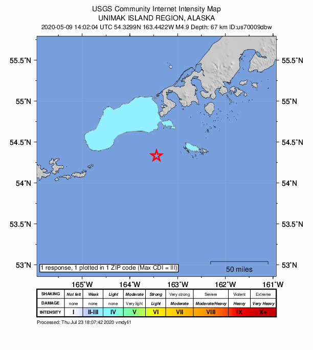
How well it is located
Reviewed by a seismologist.
- Location uncertainty
- About 6.6 km horizontally, 13.0 km in depth
- Magnitude uncertainty
- ±0.03
- Depth from
- From location
- Station coverage gap
- 177°
- Stations used
- 33
Nearest places
Distance and direction from each place to the epicenter, with its forecast.
Nearby
Within 100 km, magnitude 1.9 and up: 60 in the 60 days after this one and 35 in the 30 days before it.
After
- 2.052 km S of False Pass, Alaska · 2332 days ago · 59 km deep · 9 km away
- 2.554 km SW of False Pass, Alaska · 2331 days ago · 91 km deep · 44 km away
- 1.992 km ESE of Akutan, Alaska · 2330 days ago · 62 km deep · 82 km away
- 2.569 km SSE of False Pass, Alaska · 2328 days ago · 35 km deep · 36 km away
- 2.2107 km SSW of False Pass, Alaska · 2328 days ago · 18 km deep · 58 km away
- 1.927 km SSE of False Pass, Alaska · 2328 days ago · 13 km deep · 33 km away
- 1.927 km S of False Pass, Alaska · 2326 days ago · 13 km deep · 32 km away
- 2.7125 km S of False Pass, Alaska · 2325 days ago · 35 km deep · 69 km away
- 2.489 km SSW of False Pass, Alaska · 2323 days ago · 53 km deep · 34 km away
- 2.241 km SW of King Cove, Alaska · 2321 days ago · 79 km deep · 68 km away
- 2.784 km SSW of False Pass, Alaska · 2320 days ago · 70 km deep · 41 km away
- 1.968 km WSW of False Pass, Alaska · 2319 days ago · 5 km deep · 71 km away
- 2.1104 km ESE of Akutan, Alaska · 2319 days ago · 60 km deep · 78 km away
- 2.016 km SSW of Cold Bay, Alaska · 2317 days ago · 118 km deep · 90 km away
- 2.5139 km S of False Pass, Alaska · 2316 days ago · 25 km deep · 82 km away
- 2.993 km S of False Pass, Alaska · 2316 days ago · 24 km deep · 36 km away
- 2.895 km SSE of False Pass, Alaska · 2316 days ago · 35 km deep · 53 km away
- 2.6109 km ESE of Akutan, Alaska · 2315 days ago · 35 km deep · 69 km away
- 2.979 km WSW of False Pass, Alaska · 2315 days ago · 185 km deep · 85 km away
- 2.125 km S of False Pass, Alaska · 2313 days ago · 13 km deep · 34 km away
- 3.880 km SE of False Pass, Alaska · 2313 days ago · 34 km deep · 52 km away
- 2.1Unimak Island region, Alaska · 2308 days ago · 82 km deep · 44 km away
- 2.071 km SSW of False Pass, Alaska · 2308 days ago · 49 km deep · 18 km away
- 1.989 km S of False Pass, Alaska · 2308 days ago · 25 km deep · 31 km away
- 4.0108 km ESE of Akutan, Alaska · 2307 days ago · 41 km deep · 73 km away
- 2.099 km E of Akutan, Alaska · 2307 days ago · 81 km deep · 68 km away
- 2.0109 km ESE of Akutan, Alaska · 2307 days ago · 26 km deep · 78 km away
- 2.587 km E of Akutan, Alaska · 2307 days ago · 101 km deep · 68 km away
- 3.3116 km ESE of Akutan, Alaska · 2307 days ago · 45 km deep · 76 km away
- 3.0102 km SE of False Pass, Alaska · 2306 days ago · 10 km deep · 70 km away
- 2.1118 km SSW of False Pass, Alaska · 2303 days ago · 26 km deep · 63 km away
- 2.1112 km ESE of Akutan, Alaska · 2302 days ago · 25 km deep · 75 km away
- 2.7144 km SSE of False Pass, Alaska · 2302 days ago · 10 km deep · 92 km away
- 2.930 km NNW of False Pass, Alaska · 2302 days ago · 156 km deep · 88 km away
- 1.9Alaska Peninsula · 2302 days ago · 51 km deep · 97 km away
- 3.5149 km SSE of False Pass, Alaska · 2297 days ago · 10 km deep · 96 km away
- 3.1103 km ESE of Akutan, Alaska · 2296 days ago · 27 km deep · 96 km away
- 3.535 km W of Cold Bay, Alaska · 2294 days ago · 187 km deep · 99 km away
- 2.691 km SSE of False Pass, Alaska · 2292 days ago · 28 km deep · 53 km away
- 2.890 km SE of False Pass, Alaska · 2288 days ago · 18 km deep · 62 km away
- 1.951 km S of King Cove, Alaska · 2287 days ago · 50 km deep · 76 km away
- 3.2119 km ESE of Akutan, Alaska · 2285 days ago · 34 km deep · 81 km away
- 2.6114 km ESE of Akutan, Alaska · 2285 days ago · 35 km deep · 79 km away
- 2.4107 km ESE of Akutan, Alaska · 2285 days ago · 16 km deep · 79 km away
- 2.3109 km SSW of False Pass, Alaska · 2285 days ago · 51 km deep · 54 km away
- 2.991 km S of King Cove, Alaska · 2284 days ago · 20 km deep · 85 km away
- 2.840 km SSW of King Cove, Alaska · 2283 days ago · 5 km deep · 74 km away
- 2.046 km S of King Cove, Alaska · 2282 days ago · 75 km deep · 85 km away
- 1.9106 km ESE of Akutan, Alaska · 2282 days ago · 65 km deep · 80 km away
- 1.998 km ESE of Akutan, Alaska · 2282 days ago · 64 km deep · 77 km away
- 2.1117 km SSW of False Pass, Alaska · 2282 days ago · 134 km deep · 62 km away
- 2.089 km E of Akutan, Alaska · 2281 days ago · 20 km deep · 64 km away
- 2.089 km E of Akutan, Alaska · 2281 days ago · 19 km deep · 65 km away
- 1.934 km SW of King Cove, Alaska · 2280 days ago · 13 km deep · 74 km away
- 2.7103 km S of King Cove, Alaska · 2280 days ago · 35 km deep · 72 km away
- 2.490 km S of False Pass, Alaska · 2279 days ago · 53 km deep · 33 km away
- 1.931 km SSW of King Cove, Alaska · 2277 days ago · 13 km deep · 79 km away
- 1.963 km S of King Cove, Alaska · 2276 days ago · 62 km deep · 76 km away
- 2.670 km S of King Cove, Alaska · 2275 days ago · 68 km deep · 84 km away
- 1.9155 km S of False Pass, Alaska · 2274 days ago · 26 km deep · 97 km away
Before
- 2.669 km S of False Pass, Alaska · 2334 days ago · 35 km deep · 17 km away
- 3.955 km S of King Cove, Alaska · 2335 days ago · 35 km deep · 81 km away
- 2.8103 km ESE of Akutan, Alaska · 2337 days ago · 35 km deep · 71 km away
- 2.555 km SSW of False Pass, Alaska · 2337 days ago · 86 km deep · 25 km away
- 2.092 km S of False Pass, Alaska · 2337 days ago · 58 km deep · 35 km away
- 2.393 km SW of False Pass, Alaska · 2338 days ago · 115 km deep · 60 km away
- 2.015 km E of False Pass, Alaska · 2340 days ago · 147 km deep · 59 km away
- 2.199 km S of False Pass, Alaska · 2341 days ago · 26 km deep · 44 km away
- 2.6152 km SSE of False Pass, Alaska · 2341 days ago · 10 km deep · 99 km away
- 2.158 km S of King Cove, Alaska · 2342 days ago · 42 km deep · 83 km away
- 2.8147 km S of False Pass, Alaska · 2342 days ago · 28 km deep · 90 km away
- 2.0101 km ESE of Akutan, Alaska · 2342 days ago · 41 km deep · 89 km away
- 1.912 km WSW of King Cove, Alaska · 2343 days ago · 107 km deep · 97 km away
- 1.992 km S of False Pass, Alaska · 2343 days ago · 18 km deep · 35 km away
- 2.775 km SSW of False Pass, Alaska · 2343 days ago · 62 km deep · 25 km away
- 2.2113 km ESE of Akutan, AK · 2344 days ago · 61 km deep · 69 km away
- 2.599 km S of False Pass, Alaska · 2345 days ago · 27 km deep · 42 km away
- 2.071 km E of Akutan, Alaska · 2345 days ago · 74 km deep · 84 km away
- 2.129 km E of False Pass, Alaska · 2349 days ago · 116 km deep · 67 km away
- 2.657 km S of False Pass, Alaska · 2350 days ago · 65 km deep · 6 km away
Earthquakes todayAlaska earthquakesLive radar here
Sources
From the USGS Earthquake Hazards Program and its partner networks, event us70009dbw (also filed as ak0205z87ma2). Read Tue, Sep 29, 2026, 5:20 AM UTC.