M5.0 earthquake 82 km SSE of False Pass, Alaska
A magnitude 5.0 earthquake struck 82 km SSE of False Pass, Alaska on Thu, Aug 20, 2020, 8:35 AM AKDT (16:35 UTC), 53 km (33 mi) below the surface.
Map
Where this earthquake was located, with the others nearby. Select one for its page.
The earthquake
- Magnitude
- 5.0 (mww), moderate
- Local time
- UTC
- 2020-08-20 16:35:10 UTC
- Depth
- 52.9 km (32.9 mi), shallow
- Epicenter
- 54.215° N, 162.776° W
- Region
- Alaska
- Felt reports
- 5
- Tsunami flag
- No
- Status
- Reviewed by a seismologist
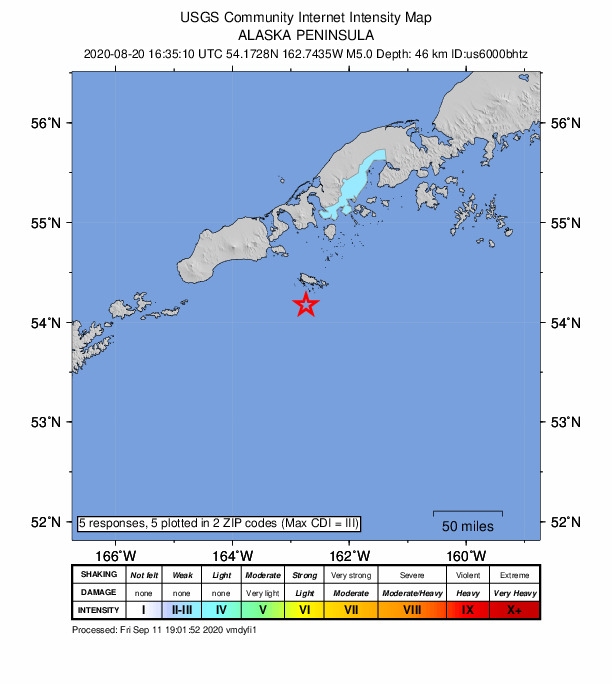
Did you feel it?
5 people reported to the USGS what they felt; the strongest reported shaking was IV, light shaking.
Fault motion and ground failure
How the rock slipped, from the moment tensor, and the USGS estimate of landslides and liquefaction.
- Faulting
- Reverse (thrust)
- Moment magnitude
- 4.9 Mwr
- Nodal plane 1
- Strike 127°, dip 48°, rake 114°
- Nodal plane 2
- Strike 273°, dip 47°, rake 65°
How well it is located
Reviewed by a seismologist.
- Location uncertainty
- About 4.9 km horizontally, 5.2 km in depth
- Magnitude uncertainty
- ±0.04
- Depth from
- From location
- Station coverage gap
- 46°
- Stations used
- 261
Nearest places
Distance and direction from each place to the epicenter, with its forecast.
Nearby
Within 100 km, magnitude 2.0 and up: 66 in the 60 days after this one and 24 in the 30 days before it.
After
- 2.1103 km S of False Pass, Alaska · 2228 days ago · 35 km deep · 45 km away
- 2.199 km E of Akutan, Alaska · 2225 days ago · 26 km deep · 97 km away
- 3.2152 km S of False Pass, Alaska · 2225 days ago · 34 km deep · 96 km away
- 2.319 km SSW of False Pass, Alaska · 2224 days ago · 145 km deep · 75 km away
- 2.667 km SSE of King Cove, Alaska · 2223 days ago · 19 km deep · 72 km away
- 2.294 km SSE of King Cove, Alaska · 2219 days ago · 28 km deep · 83 km away
- 3.073 km SSE of King Cove, Alaska · 2219 days ago · 24 km deep · 76 km away
- 2.340 km S of False Pass, Alaska · 2219 days ago · 74 km deep · 52 km away
- 2.6107 km SSE of King Cove, Alaska · 2219 days ago · 35 km deep · 83 km away
- 4.2101 km SSW of False Pass, Alaska · 2217 days ago · 22 km deep · 94 km away
- 2.6116 km SSW of False Pass, Alaska · 2216 days ago · 35 km deep · 85 km away
- 2.2123 km SSE of King Cove, Alaska · 2215 days ago · 24 km deep · 88 km away
- 3.5120 km SSW of False Pass, Alaska · 2214 days ago · 27 km deep · 90 km away
- 2.697 km SE of False Pass, Alaska · 2213 days ago · 32 km deep · 18 km away
- 2.3124 km SSE of False Pass, Alaska · 2213 days ago · 35 km deep · 43 km away
- 2.325 km S of False Pass, Alaska · 2211 days ago · 4 km deep · 59 km away
- 3.1103 km SE of King Cove, Alaska · 2211 days ago · 21 km deep · 92 km away
- 2.651 km S of King Cove, Alaska · 2210 days ago · 54 km deep · 58 km away
- 3.969 km S of King Cove, Alaska · 2209 days ago · 81 km deep · 35 km away
- 2.057 km SSW of False Pass, Alaska · 2205 days ago · 91 km deep · 72 km away
- 2.114 km E of False Pass, Alaska · 2205 days ago · 128 km deep · 76 km away
- 2.5105 km SSW of False Pass, Alaska · 2203 days ago · 35 km deep · 71 km away
- 3.196 km SSE of King Cove, Alaska · 2203 days ago · 6 km deep · 79 km away
- 2.6104 km SSE of False Pass, Alaska · 2199 days ago · 33 km deep · 23 km away
- 3.7150 km S of False Pass, Alaska · 2197 days ago · 22 km deep · 95 km away
- 3.0104 km SE of False Pass, Alaska · 2197 days ago · 30 km deep · 24 km away
- 3.0112 km SSE of False Pass, Alaska · 2195 days ago · 20 km deep · 39 km away
- 3.282 km S of False Pass, Alaska · 2195 days ago · 29 km deep · 30 km away
- 2.696 km SSW of False Pass, Alaska · 2195 days ago · 35 km deep · 95 km away
- 2.9106 km SE of King Cove, Alaska · 2194 days ago · 7 km deep · 92 km away
- 2.215 km SSW of Cold Bay, Alaska · 2193 days ago · 131 km deep · 93 km away
- 2.081 km S of King Cove, Alaska · 2193 days ago · 26 km deep · 47 km away
- 2.391 km SSE of False Pass, Alaska · 2192 days ago · 9 km deep · 9 km away
- 2.251 km SE of King Cove, Alaska · 2191 days ago · 74 km deep · 96 km away
- 2.568 km SSE of False Pass, Alaska · 2191 days ago · 35 km deep · 16 km away
- 2.0Alaska Peninsula · 2188 days ago · 78 km deep · 64 km away
- 2.6Unimak Island region, Alaska · 2188 days ago · 34 km deep · 69 km away
- 2.817 km SSW of King Cove, Alaska · 2187 days ago · 86 km deep · 81 km away
- 2.4154 km S of False Pass, Alaska · 2187 days ago · 40 km deep · 93 km away
- 2.684 km S of King Cove, Alaska · 2186 days ago · 35 km deep · 34 km away
- 2.326 km S of False Pass, Alaska · 2185 days ago · 13 km deep · 58 km away
- 2.931 km S of False Pass, Alaska · 2185 days ago · 24 km deep · 53 km away
- 3.235 km SSE of False Pass, Alaska · 2185 days ago · 18 km deep · 49 km away
- 2.7102 km SE of King Cove, Alaska · 2183 days ago · 10 km deep · 91 km away
- 4.4104 km SE of King Cove, Alaska · 2183 days ago · 6 km deep · 93 km away
- 3.240 km SSE of False Pass, Alaska · 2183 days ago · 10 km deep · 45 km away
- 2.7101 km SE of King Cove, Alaska · 2183 days ago · 10 km deep · 92 km away
- 3.1107 km SE of King Cove, Alaska · 2183 days ago · 10 km deep · 98 km away
- 2.029 km SSE of False Pass, Alaska · 2182 days ago · 5 km deep · 55 km away
- 2.998 km E of Akutan, Alaska · 2180 days ago · 63 km deep · 100 km away
- 2.1107 km SE of King Cove, Alaska · 2180 days ago · 25 km deep · 92 km away
- 3.3153 km S of False Pass, Alaska · 2179 days ago · 20 km deep · 95 km away
- 2.9122 km SSW of False Pass, Alaska · 2178 days ago · 23 km deep · 90 km away
- 2.5127 km S of False Pass, Alaska · 2177 days ago · 14 km deep · 66 km away
- 2.483 km S of False Pass, Alaska · 2177 days ago · 48 km deep · 54 km away
- 2.9103 km SE of King Cove, Alaska · 2177 days ago · 10 km deep · 96 km away
- 2.191 km S of False Pass, Alaska · 2176 days ago · 25 km deep · 56 km away
- 2.330 km W of False Pass, Alaska · 2176 days ago · 157 km deep · 98 km away
- 3.7100 km S of King Cove, Alaska · 2175 days ago · 35 km deep · 28 km away
- 3.791 km S of King Cove, Alaska · 2175 days ago · 35 km deep · 28 km away · felt by 1
The first 60 of 66.
Before
- 2.188 km SE of King Cove, Alaska · 2229 days ago · 41 km deep · 99 km away
- 2.786 km SSE of False Pass, Alaska · 2231 days ago · 5 km deep · 6 km away
- 2.1145 km S of False Pass, Alaska · 2233 days ago · 42 km deep · 91 km away
- 2.1122 km S of False Pass, Alaska · 2237 days ago · 22 km deep · 80 km away
- 2.0102 km SSW of False Pass, Alaska · 2238 days ago · 62 km deep · 91 km away
- 2.1117 km SSE of False Pass, Alaska · 2238 days ago · 25 km deep · 38 km away
- 2.3105 km SSE of False Pass, Alaska · 2239 days ago · 26 km deep · 36 km away
- 3.0121 km S of False Pass, Alaska · 2240 days ago · 33 km deep · 73 km away
- 2.097 km SSW of False Pass, Alaska · 2244 days ago · 64 km deep · 66 km away
- 2.575 km SSW of False Pass, Alaska · 2246 days ago · 52 km deep · 62 km away
- 2.7109 km SE of King Cove, Alaska · 2246 days ago · 17 km deep · 95 km away
- 2.127 km S of False Pass, Alaska · 2247 days ago · 105 km deep · 58 km away
- 2.0115 km SSE of False Pass, Alaska · 2247 days ago · 58 km deep · 39 km away
- 2.0114 km SSW of False Pass, Alaska · 2248 days ago · 26 km deep · 82 km away
- 2.169 km S of False Pass, Alaska · 2248 days ago · 25 km deep · 49 km away
- 3.5114 km S of False Pass, Alaska · 2249 days ago · 35 km deep · 53 km away
- 2.9103 km SSE of King Cove, Alaska · 2249 days ago · 9 km deep · 77 km away
- 3.446 km S of False Pass, Alaska · 2250 days ago · 85 km deep · 45 km away
- 2.087 km SSE of King Cove, Alaska · 2250 days ago · 13 km deep · 79 km away
- 2.0103 km S of False Pass, Alaska · 2251 days ago · 8 km deep · 48 km away
Earthquakes todayAlaska earthquakesLive radar here
Sources
From the USGS Earthquake Hazards Program and its partner networks, event us6000bhtz (also filed as ak020aplyc6l, iscgem618743315). Read Sat, Sep 26, 2026, 11:18 PM UTC.