M2.4 earthquake 20km S of Big Pine, CA
A magnitude 2.4 earthquake struck 20km S of Big Pine, CA on Sun, Mar 1, 2020, 12:01 PM PST (20:01 UTC), 6 km (4 mi) below the surface.
A larger quake followed: M4.0 16km WSW of Toms Place, CA. This one was a foreshock.
Map
Where this earthquake was located, with the others nearby. Select one for its page.
The earthquake
- Magnitude
- 2.4 (Md, duration), micro
- Magnitude from
- Northern California Seismic System
- Local time
- UTC
- 2020-03-01 20:01:05 UTC
- Depth
- 5.6 km (3.5 mi), shallow
- Epicenter
- 36.985° N, 118.317° W
- Region
- California
- Tsunami flag
- No
- Status
- Reviewed by a seismologist
Magnitude estimates
Different scales measure different things and differ by a few tenths. The USGS marks one as preferred, and it is the one this page uses.
| Mag. | Scale | Computed by | Notes |
|---|---|---|---|
| 2.42 | Md, duration | Northern California Seismic System | Preferred · Final · ±0.217 · 30 stations |
| 2.2 | ML, local (Richter) | Nevada Seismological Laboratory | Reviewed · ±0.45 · 6 stations |
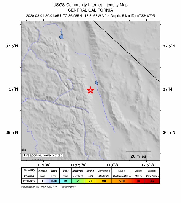
Did you feel it?
No one has reported feeling this quake to the USGS.
How well it is located
Reviewed by a seismologist.
- Location uncertainty
- About 1.1 km horizontally, 1.9 km in depth
- Magnitude uncertainty
- ±0.22
- Depth from
- From location
- Station coverage gap
- 179°
- Stations used
- 26
Nearest places
Distance and direction from each place to the epicenter, with its forecast.
Nearby
Within 100 km, magnitude 1.5 and up: 156 in the 60 days after this one and 68 in the 30 days before it.
After
- 2.06km ENE of Mammoth Lakes, CA · 2403 days ago · 2 km deep · 91 km away
- 1.718km SW of Olancha, CA · 2402 days ago · 3 km deep · 89 km away
- 2.018km SW of Olancha, CA · 2402 days ago · 7 km deep · 89 km away
- 2.218km SW of Olancha, CA · 2402 days ago · 5 km deep · 89 km away
- 2.318km SW of Olancha, CA · 2402 days ago · 4 km deep · 90 km away
- 1.618km SW of Olancha, CA · 2402 days ago · 5 km deep · 89 km away
- 1.818km SW of Olancha, CA · 2402 days ago · 3 km deep · 89 km away
- 1.818km SW of Olancha, CA · 2402 days ago · 5 km deep · 89 km away
- 1.818km SW of Olancha, CA · 2402 days ago · 3 km deep · 89 km away
- 1.618km SW of Olancha, CA · 2402 days ago · 3 km deep · 90 km away
- 1.62km S of Round Valley, CA · 2402 days ago · 10 km deep · 52 km away
- 2.218km SW of Olancha, CA · 2402 days ago · 3 km deep · 90 km away
- 1.611km ENE of Mammoth Lakes, CA · 2401 days ago · 3 km deep · 89 km away
- 1.718km SW of Toms Place, CA · 2400 days ago · 8 km deep · 71 km away
- 1.718km SW of Olancha, CA · 2400 days ago · 5 km deep · 89 km away
- 1.917km SE of Olancha, CA · 2398 days ago · 5 km deep · 98 km away
- 1.613km SW of Toms Place, CA · 2397 days ago · 2 km deep · 69 km away
- 2.434km ENE of Lone Pine, CA · 2395 days ago · 2 km deep · 61 km away
- 1.74km E of Mammoth Lakes, CA · 2395 days ago · 5 km deep · 91 km away
- 2.010km SSW of Olancha, CA · 2394 days ago · 2 km deep · 91 km away
- 1.516km SSW of Olancha, CA · 2394 days ago · 1 km deep · 95 km away
- 1.96km SSW of Mammoth Lakes, CA · 2394 days ago · 1 km deep · 92 km away
- 1.66km SSW of Mammoth Lakes, CA · 2393 days ago · 1 km deep · 91 km away
- 3.025 km SSW of Silver Peak, Nevada · 2393 days ago · 6 km deep · 80 km away
- 4.025 km SSW of Silver Peak, Nevada · 2393 days ago · 6 km deep · 80 km away · felt by 9
- 2.325 km SSW of Silver Peak, Nevada · 2393 days ago · 5 km deep · 80 km away
- 1.925 km SSW of Silver Peak, Nevada · 2393 days ago · 5 km deep · 80 km away
- 1.725 km SSW of Silver Peak, Nevada · 2393 days ago · 0 km deep · 80 km away
- 1.825 km SSW of Silver Peak, Nevada · 2393 days ago · 0 km deep · 80 km away
- 1.712km SSW of Toms Place, CA · 2393 days ago · 5 km deep · 64 km away
- 2.124 km SSW of Silver Peak, Nevada · 2393 days ago · 0 km deep · 81 km away
- 2.324 km SSW of Silver Peak, Nevada · 2393 days ago · 0 km deep · 81 km away
- 2.124 km SSW of Silver Peak, Nevada · 2393 days ago · 0 km deep · 81 km away
- 1.925 km SSW of Silver Peak, Nevada · 2393 days ago · 2 km deep · 80 km away
- 2.125 km SSW of Silver Peak, Nevada · 2393 days ago · 4 km deep · 80 km away
- 1.65km SSW of Mammoth Lakes, CA · 2393 days ago · 1 km deep · 92 km away
- 1.65km SSW of Mammoth Lakes, CA · 2393 days ago · 1 km deep · 92 km away
- 1.526 km SSW of Silver Peak, Nevada · 2392 days ago · 7 km deep · 79 km away
- 1.526 km SSW of Silver Peak, Nevada · 2392 days ago · 0 km deep · 79 km away
- 2.224 km SSW of Silver Peak, Nevada · 2392 days ago · 0 km deep · 81 km away
- 1.724 km SSW of Silver Peak, Nevada · 2392 days ago · 0 km deep · 81 km away
- 1.524 km SSW of Silver Peak, Nevada · 2392 days ago · 0 km deep · 81 km away
- 1.75km SSW of Mammoth Lakes, CA · 2392 days ago · 1 km deep · 92 km away
- 2.424 km SSW of Silver Peak, Nevada · 2392 days ago · 0 km deep · 81 km away
- 2.326 km SSW of Silver Peak, Nevada · 2392 days ago · 0 km deep · 79 km away
- 1.725 km SSW of Silver Peak, Nevada · 2392 days ago · 0 km deep · 80 km away
- 1.812km SSW of Toms Place, CA · 2391 days ago · 6 km deep · 64 km away
- 1.72km SSE of Round Valley, CA · 2390 days ago · 12 km deep · 52 km away
- 1.637km WSW of Olancha, CA · 2389 days ago · 6 km deep · 91 km away
- 1.814km WSW of Toms Place, CA · 2388 days ago · 8 km deep · 75 km away
- 1.625 km SSW of Silver Peak, Nevada · 2388 days ago · 4 km deep · 80 km away
- 1.626 km SSW of Silver Peak, Nevada · 2388 days ago · 6 km deep · 79 km away
- 2.118km NNE of Coso Junction, CA · 2388 days ago · 2 km deep · 99 km away
- 1.68km ESE of Mammoth Lakes, CA · 2387 days ago · 6 km deep · 87 km away
- 1.91km S of Round Valley, CA · 2387 days ago · 9 km deep · 53 km away
- 1.511km ENE of Mammoth Lakes, CA · 2385 days ago · 2 km deep · 89 km away
- 2.120km SW of Toms Place, CA · 2384 days ago · 4 km deep · 69 km away
- 1.837 km NE of Independence, California · 2384 days ago · 8 km deep · 40 km away
- 1.913km NW of Coso Junction, CA · 2383 days ago · 1 km deep · 99 km away
- 1.912km SW of Toms Place, CA · 2383 days ago · 8 km deep · 68 km away
The first 60 of 156.
Before
- 2.018km WSW of Toms Place, CA · 2407 days ago · 8 km deep · 72 km away
- 1.912 km NNE of Coso Junction, CA · 2407 days ago · 4 km deep · 100 km away
- 1.931 km SSE of Dyer, Nevada · 2408 days ago · 10 km deep · 59 km away
- 2.129km ESE of Big Pine, CA · 2408 days ago · -2 km deep · 33 km away
- 1.62km NW of Round Valley, CA · 2408 days ago · 10 km deep · 55 km away
- 1.917 km NE of Olancha, CA · 2410 days ago · 1 km deep · 78 km away
- 2.419km S of Big Pine, CA · 2410 days ago · 5 km deep · 2 km away
- 1.92km E of Round Valley, CA · 2410 days ago · 11 km deep · 53 km away
- 1.96km E of Mammoth Lakes, CA · 2410 days ago · 2 km deep · 89 km away
- 1.52km SSW of Bishop, CA · 2411 days ago · 8 km deep · 41 km away
- 1.514km ESE of Mammoth Lakes, CA · 2412 days ago · -1 km deep · 81 km away
- 2.26km SSW of Mammoth Lakes, CA · 2413 days ago · 2 km deep · 92 km away
- 1.65km SE of Round Valley, CA · 2414 days ago · 3 km deep · 50 km away
- 1.78km NNW of Round Valley, CA · 2414 days ago · 7 km deep · 62 km away
- 1.67km ESE of Round Valley, CA · 2416 days ago · 10 km deep · 49 km away
- 2.412km SSW of Toms Place, CA · 2417 days ago · 4 km deep · 65 km away
- 2.414km SW of Olancha, CA · 2417 days ago · 2 km deep · 88 km away
- 1.76km SSW of Mammoth Lakes, CA · 2417 days ago · 1 km deep · 91 km away
- 1.614km SW of Olancha, CA · 2417 days ago · 3 km deep · 88 km away
- 1.814km SW of Olancha, CA · 2417 days ago · 3 km deep · 88 km away
Earthquakes todayCalifornia earthquakesLive radar here
Sources
From the USGS Earthquake Hazards Program and its partner networks, event nc73348725 (also filed as nn00718104). Read Fri, Oct 2, 2026, 6:01 AM UTC.