M5.2 earthquake 52 km WNW of Adak, Alaska
A magnitude 5.2 earthquake struck 52 km WNW of Adak, Alaska on Tue, Jul 14, 2020, 11:59 PM HADT (08:59 UTC), 12 km (7 mi) below the surface.
Map
Where this earthquake was located, with the others nearby. Select one for its page.
The earthquake
- Magnitude
- 5.2 (mww), moderate
- Local time
- UTC
- 2020-07-15 08:59:54 UTC
- Depth
- 11.8 km (7.3 mi), shallow
- Epicenter
- 51.979° N, 177.377° W
- Region
- Alaska
- Felt reports
- 2
- Tsunami flag
- Yes: a large quake in an oceanic region
- Status
- Reviewed by a seismologist
Tsunami
The USGS flags a quake this large in an oceanic region. The flag does not mean a tsunami happened; the tsunami warning centers decide that, and their messages are below when they issued any.
Current tsunami warnings: tsunami.gov. Warnings in force in the US also appear on our alerts pages.
Did you feel it?
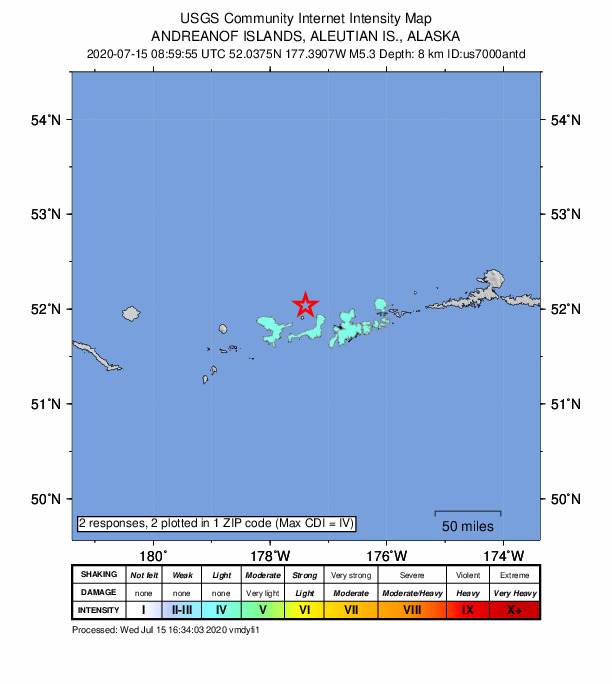
2 people reported to the USGS what they felt; the strongest reported shaking was IV, light shaking.
Fault motion and ground failure
How the rock slipped, from the moment tensor, and the USGS estimate of landslides and liquefaction.
- Faulting
- Strike-slip
- Moment magnitude
- 5.2 Mww
- Nodal plane 1
- Strike 176°, dip 65°, rake 9°
- Nodal plane 2
- Strike 82°, dip 82°, rake 155°
How well it is located
Reviewed by a seismologist.
- Location uncertainty
- About 2.4 km horizontally, 1.6 km in depth
- Magnitude uncertainty
- ±0.04
- Depth from
- From location
- Station coverage gap
- 22°
- Stations used
- 114
Nearby
Within 100 km, magnitude 2.2 and up: 38 in the 60 days after this one and 25 in the 30 days before it.
After
- 2.655 km WNW of Adak, Alaska · 2267 days ago · 10 km deep · 14 km away
- 2.850 km W of Adak, Alaska · 2267 days ago · 18 km deep · 17 km away
- 3.732 km S of Adak, Alaska · 2266 days ago · 54 km deep · 66 km away
- 2.338 km WSW of Adak, Alaska · 2265 days ago · 15 km deep · 27 km away
- 2.241 km ENE of Adak, Alaska · 2265 days ago · 125 km deep · 90 km away
- 3.879 km SW of Adak, Alaska · 2264 days ago · 32 km deep · 67 km away
- 2.647 km SSW of Adak, Alaska · 2259 days ago · 22 km deep · 58 km away
- 4.3120 km WNW of Adak, Alaska · 2258 days ago · 234 km deep · 72 km away
- 3.848 km S of Adak, Alaska · 2258 days ago · 42 km deep · 74 km away
- 2.549 km E of Adak, Alaska · 2250 days ago · 111 km deep · 100 km away
- 2.939 km WSW of Adak, Alaska · 2250 days ago · 17 km deep · 38 km away
- 3.41 km NW of Adak, Alaska · 2249 days ago · 93 km deep · 51 km away
- 2.818 km ENE of Adak, Alaska · 2248 days ago · 106 km deep · 69 km away
- 2.584 km SW of Adak, Alaska · 2247 days ago · 36 km deep · 65 km away
- 2.712 km S of Adak, Alaska · 2247 days ago · 84 km deep · 57 km away
- 2.7125 km WSW of Adak, Alaska · 2246 days ago · 35 km deep · 94 km away
- 2.768 km WSW of Adak, Alaska · 2244 days ago · 10 km deep · 46 km away
- 3.656 km SSW of Adak, Alaska · 2242 days ago · 35 km deep · 64 km away
- 3.8128 km SW of Adak, Alaska · 2241 days ago · 26 km deep · 100 km away
- 3.018 km S of Adak, Alaska · 2239 days ago · 69 km deep · 60 km away
- 3.2130 km WSW of Adak, Alaska · 2237 days ago · 88 km deep · 86 km away
- 2.7131 km WSW of Adak, Alaska · 2237 days ago · 10 km deep · 91 km away
- 3.3128 km WSW of Adak, Alaska · 2234 days ago · 10 km deep · 87 km away
- 2.842 km ENE of Adak, Alaska · 2234 days ago · 159 km deep · 90 km away
- 3.8133 km W of Adak, Alaska · 2234 days ago · 145 km deep · 82 km away
- 3.638 km SE of Adak, Alaska · 2233 days ago · 68 km deep · 89 km away
- 3.459 km SSW of Adak, Alaska · 2227 days ago · 35 km deep · 80 km away
- 3.6Andreanof Islands, Aleutian Islands, Alaska · 2222 days ago · 35 km deep · 90 km away
- 2.618 km S of Adak, Alaska · 2222 days ago · 66 km deep · 62 km away
- 4.3126 km WSW of Adak, Alaska · 2221 days ago · 34 km deep · 86 km away
- 2.551 km SW of Adak, Alaska · 2221 days ago · 33 km deep · 55 km away
- 4.6125 km W of Adak, Alaska · 2215 days ago · 18 km deep · 77 km away · felt by 1
- 2.689 km WSW of Adak, Alaska · 2214 days ago · 64 km deep · 60 km away
- 2.6101 km SW of Adak, Alaska · 2213 days ago · 35 km deep · 87 km away
- 2.637 km SSE of Adak, Alaska · 2212 days ago · 46 km deep · 80 km away
- 2.651 km SW of Adak, Alaska · 2212 days ago · 57 km deep · 54 km away
- 2.463 km NE of Adak, Alaska · 2209 days ago · 210 km deep · 99 km away
- 3.5103 km W of Adak, Alaska · 2208 days ago · 17 km deep · 54 km away
Before
- 3.332 km S of Adak, Alaska · 2267 days ago · 35 km deep · 63 km away
- 2.849 km SSE of Adak, Alaska · 2269 days ago · 35 km deep · 93 km away
- 3.4124 km SW of Adak, Alaska · 2273 days ago · 30 km deep · 98 km away
- 3.9138 km WNW of Adak, Alaska · 2274 days ago · 180 km deep · 86 km away
- 2.8129 km WSW of Adak, Alaska · 2274 days ago · 10 km deep · 87 km away
- 2.241 km ENE of Adak, Alaska · 2275 days ago · 5 km deep · 88 km away
- 2.666 km WSW of Adak, Alaska · 2275 days ago · 74 km deep · 38 km away
- 2.735 km SSE of Adak, Alaska · 2275 days ago · 58 km deep · 81 km away
- 4.0122 km WSW of Adak, Alaska · 2278 days ago · 45 km deep · 92 km away
- 2.667 km S of Adak, Alaska · 2278 days ago · 35 km deep · 87 km away
- 2.8122 km WSW of Adak, Alaska · 2278 days ago · 10 km deep · 82 km away
- 3.353 km NE of Adak, Alaska · 2284 days ago · 151 km deep · 94 km away
- 2.875 km SSW of Adak, Alaska · 2285 days ago · 35 km deep · 82 km away
- 3.089 km SW of Adak, Alaska · 2286 days ago · 44 km deep · 78 km away
- 2.547 km SSE of Adak, Alaska · 2286 days ago · 32 km deep · 90 km away
- 2.736 km SE of Adak, Alaska · 2286 days ago · 67 km deep · 86 km away
- 2.5118 km SW of Adak, Alaska · 2288 days ago · 35 km deep · 95 km away
- 2.470 km WSW of Adak, Alaska · 2290 days ago · 77 km deep · 46 km away
- 2.872 km SSW of Adak, Alaska · 2291 days ago · 41 km deep · 78 km away
- 3.867 km SSW of Adak, Alaska · 2291 days ago · 44 km deep · 72 km away
Earthquakes todayAlaska earthquakesLive radar here
Sources
From the USGS Earthquake Hazards Program and its partner networks, event us7000antd (also filed as at00qdi6bv, ak02091xzljz, av61907958, iscgem618680826). Read Tue, Sep 29, 2026, 5:30 AM UTC.