M3.8 earthquake 61 km ESE of Adak, Alaska
A magnitude 3.8 earthquake struck 61 km ESE of Adak, Alaska on Sun, Jul 5, 2020, 8:46 AM HADT (17:46 UTC), 52 km (32 mi) below the surface.
A larger quake followed: M4.0 72 km NE of Adak, Alaska. This one was a foreshock.
Map
Where this earthquake was located, with the others nearby. Select one for its page.
The earthquake
- Magnitude
- 3.8 (mb), minor
- Local time
- UTC
- 2020-07-05 17:46:33 UTC
- Depth
- 52.2 km (32.5 mi), shallow
- Epicenter
- 51.611° N, 175.850° W
- Region
- Alaska
- Felt reports
- 1
- Tsunami flag
- No
- Status
- Reviewed by a seismologist
Did you feel it?
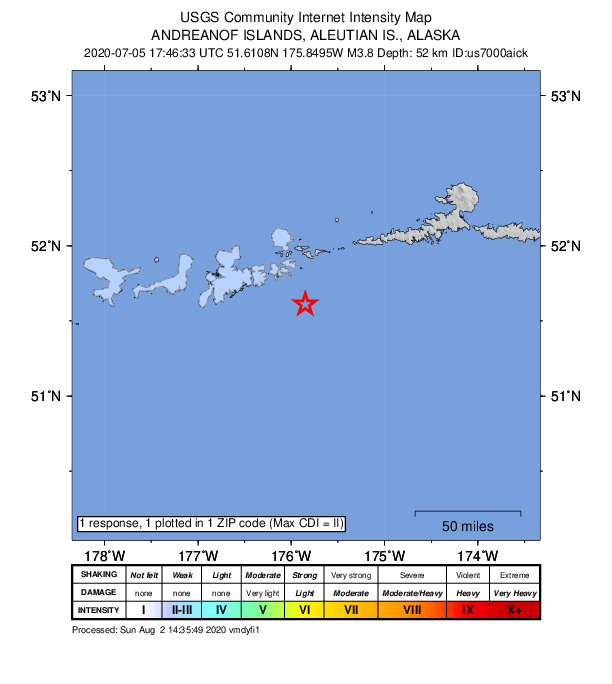
1 person reported to the USGS what they felt; the strongest reported shaking was II, weak shaking.
How well it is located
Reviewed by a seismologist.
- Location uncertainty
- About 3.6 km horizontally, 9.5 km in depth
- Magnitude uncertainty
- ±0.10
- Depth from
- From location
- Station coverage gap
- 203°, poorly surrounded by stations
- Stations used
- 42
Nearby
Within 100 km, magnitude 1.5 and up: 152 in the 60 days after this one and 81 in the 30 days before it.
After
- 2.735 km SSE of Adak, Alaska · 2276 days ago · 58 km deep · 37 km away
- 1.974 km SSE of Adak, Alaska · 2276 days ago · 20 km deep · 36 km away
- 2.590 km SW of Atka, Alaska · 2275 days ago · 35 km deep · 55 km away
- 2.241 km ENE of Adak, Alaska · 2275 days ago · 5 km deep · 52 km away
- 1.647 km ENE of Adak, Alaska · 2275 days ago · 105 km deep · 49 km away
- 2.760 km SSE of Adak, Alaska · 2275 days ago · 35 km deep · 37 km away
- 1.661 km SE of Adak, Alaska · 2275 days ago · 22 km deep · 18 km away
- 1.576 km SE of Adak, Alaska · 2275 days ago · 50 km deep · 16 km away
- 2.681 km SSW of Atka, Alaska · 2274 days ago · 28 km deep · 90 km away
- 1.748 km SSW of Adak, Alaska · 2274 days ago · 30 km deep · 70 km away
- 1.846 km ENE of Adak, Alaska · 2274 days ago · 161 km deep · 51 km away
- 1.5Andreanof Islands, Aleutian Islands, Alaska · 2274 days ago · 31 km deep · 61 km away
- 1.641 km ENE of Adak, Alaska · 2273 days ago · 4 km deep · 53 km away
- 1.848 km E of Adak, Alaska · 2273 days ago · 163 km deep · 39 km away
- 1.636 km SW of Atka, Alaska · 2273 days ago · 96 km deep · 95 km away
- 1.987 km WSW of Atka, Alaska · 2273 days ago · 58 km deep · 44 km away
- 1.857 km WSW of Atka, Alaska · 2272 days ago · 113 km deep · 75 km away
- 1.616 km NW of Adak, Alaska · 2272 days ago · 101 km deep · 78 km away
- 1.767 km ESE of Adak, Alaska · 2272 days ago · 48 km deep · 20 km away
- 1.778 km SSE of Adak, Alaska · 2272 days ago · 21 km deep · 60 km away
- 2.560 km SE of Adak, Alaska · 2271 days ago · 127 km deep · 9 km away
- 1.888 km SSE of Adak, Alaska · 2271 days ago · 0 km deep · 61 km away
- 1.561 km SSW of Adak, Alaska · 2271 days ago · 31 km deep · 82 km away
- 1.929 km SE of Adak, Alaska · 2271 days ago · 61 km deep · 37 km away
- 1.938 km ESE of Adak, Alaska · 2271 days ago · 131 km deep · 25 km away
- 1.689 km SSW of Atka, Alaska · 2270 days ago · 38 km deep · 77 km away
- 1.784 km SSW of Atka, Alaska · 2270 days ago · 25 km deep · 75 km away
- 2.885 km SSW of Atka, Alaska · 2270 days ago · 35 km deep · 81 km away
- 2.886 km SSW of Atka, Alaska · 2270 days ago · 23 km deep · 82 km away
- 1.679 km SSW of Atka, Alaska · 2270 days ago · 26 km deep · 74 km away
- 2.849 km SSE of Adak, Alaska · 2270 days ago · 35 km deep · 33 km away
- 2.696 km SE of Adak, Alaska · 2270 days ago · 23 km deep · 37 km away
- 1.542 km SSE of Adak, Alaska · 2269 days ago · 26 km deep · 37 km away
- 1.957 km ENE of Adak, Alaska · 2268 days ago · 153 km deep · 58 km away
- 2.040 km NNW of Adak, Alaska · 2268 days ago · 151 km deep · 95 km away
- 1.724 km SSW of Adak, Alaska · 2268 days ago · 60 km deep · 61 km away
- 3.332 km S of Adak, Alaska · 2268 days ago · 35 km deep · 60 km away
- 3.183 km SE of Adak, Alaska · 2267 days ago · 35 km deep · 25 km away
- 1.541 km ENE of Adak, Alaska · 2267 days ago · 5 km deep · 54 km away
- 1.956 km SSE of Adak, Alaska · 2267 days ago · 26 km deep · 42 km away
- 3.732 km S of Adak, Alaska · 2266 days ago · 54 km deep · 57 km away
- 1.662 km WSW of Atka, Alaska · 2266 days ago · 70 km deep · 68 km away
- 1.957 km SE of Adak, Alaska · 2266 days ago · 23 km deep · 17 km away
- 2.338 km WSW of Adak, Alaska · 2266 days ago · 15 km deep · 93 km away
- 2.241 km ENE of Adak, Alaska · 2265 days ago · 125 km deep · 46 km away
- 1.970 km ESE of Adak, Alaska · 2265 days ago · 26 km deep · 9 km away
- 1.822 km SE of Adak, Alaska · 2264 days ago · 208 km deep · 43 km away
- 1.567 km ESE of Adak, Alaska · 2263 days ago · 28 km deep · 6 km away
- 1.665 km SSW of Atka, Alaska · 2261 days ago · 22 km deep · 95 km away
- 2.291 km SW of Atka, Alaska · 2260 days ago · 25 km deep · 48 km away
- 1.968 km SSW of Adak, Alaska · 2260 days ago · 26 km deep · 89 km away
- 1.955 km SW of Adak, Alaska · 2259 days ago · 39 km deep · 87 km away
- 2.647 km SSW of Adak, Alaska · 2259 days ago · 22 km deep · 80 km away
- 1.547 km SW of Adak, Alaska · 2259 days ago · 26 km deep · 81 km away
- 3.848 km S of Adak, Alaska · 2258 days ago · 42 km deep · 65 km away
- 1.638 km SSW of Adak, Alaska · 2258 days ago · 34 km deep · 64 km away
- 2.076 km NE of Adak, Alaska · 2257 days ago · 219 km deep · 78 km away
- 2.185 km ESE of Adak, Alaska · 2257 days ago · 26 km deep · 25 km away
- 1.778 km SSE of Adak, Alaska · 2255 days ago · 26 km deep · 49 km away
- 1.633 km SSW of Adak, Alaska · 2255 days ago · 62 km deep · 66 km away
The first 60 of 152.
Before
- 1.668 km ESE of Adak, Alaska · 2277 days ago · 27 km deep · 7 km away
- 1.6100 km SSE of Adak, Alaska · 2277 days ago · 13 km deep · 75 km away
- 2.667 km S of Adak, Alaska · 2278 days ago · 35 km deep · 76 km away
- 1.634 km W of Atka, Alaska · 2279 days ago · 26 km deep · 99 km away
- 2.175 km SSE of Adak, Alaska · 2279 days ago · 20 km deep · 56 km away
- 1.659 km SSW of Adak, Alaska · 2280 days ago · 26 km deep · 76 km away
- 1.559 km SE of Adak, Alaska · 2280 days ago · 23 km deep · 16 km away
- 1.862 km SE of Adak, Alaska · 2280 days ago · 27 km deep · 13 km away
- 1.853 km ESE of Adak, Alaska · 2281 days ago · 71 km deep · 17 km away
- 2.140 km ENE of Adak, Alaska · 2281 days ago · 5 km deep · 52 km away
- 1.757 km SSW of Adak, Alaska · 2282 days ago · 37 km deep · 87 km away
- 1.568 km SE of Adak, Alaska · 2283 days ago · 21 km deep · 18 km away
- 3.353 km NE of Adak, Alaska · 2284 days ago · 151 km deep · 66 km away
- 2.080 km WSW of Atka, Alaska · 2285 days ago · 71 km deep · 51 km away
- 3.479 km WSW of Atka, Alaska · 2285 days ago · 76 km deep · 51 km away
- 2.875 km SSW of Adak, Alaska · 2285 days ago · 35 km deep · 95 km away
- 2.060 km SE of Adak, Alaska · 2285 days ago · 26 km deep · 19 km away
- 2.547 km SSE of Adak, Alaska · 2286 days ago · 32 km deep · 36 km away
- 3.364 km SSW of Atka, Alaska · 2286 days ago · 35 km deep · 91 km away
- 1.642 km SSW of Adak, Alaska · 2286 days ago · 30 km deep · 78 km away
Earthquakes todayAlaska earthquakesLive radar here
Sources
From the USGS Earthquake Hazards Program and its partner networks, event us7000aick (also filed as ak0208ljw6wh). Read Tue, Sep 29, 2026, 5:54 PM UTC.