M2.5 earthquake 6 km WSW of Victor, Idaho
A magnitude 2.5 earthquake struck 6 km WSW of Victor, Idaho on Tue, Apr 2, 2019, 8:50 PM MDT (02:50 UTC), 5 km (3 mi) below the surface.
A larger quake followed: M2.6 56 km SE of West Yellowstone, Montana. This one was a foreshock.
Map
Where this earthquake was located, with the others nearby. Select one for its page.
The earthquake
- Magnitude
- 2.5 (ML, local (Richter)), micro
- Magnitude from
- USGS National Earthquake Information Center
- Local time
- UTC
- 2019-04-03 02:50:07 UTC
- Depth
- 5.0 km (3.1 mi), shallow
- Epicenter
- 43.585° N, 111.182° W
- Region
- Idaho
- Felt reports
- 6
- Tsunami flag
- No
- Status
- Reviewed by a seismologist
Magnitude estimates
Different scales measure different things and differ by a few tenths. The USGS marks one as preferred, and it is the one this page uses.
| Mag. | Scale | Computed by | Notes |
|---|---|---|---|
| 2.5 | ML, local (Richter) | USGS National Earthquake Information Center | Preferred · Reviewed · ±0.048 · 56 stations |
| 2.55 | ML, local (Richter) | Montana Bureau of Mines and Geology | Final · ±0.224 · 20 stations |
Did you feel it?
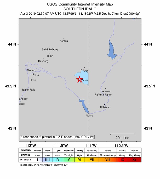
6 people reported to the USGS what they felt; the strongest reported shaking was IV, light shaking.
How well it is located
Reviewed by a seismologist.
- Location uncertainty
- About 1.7 km horizontally, 1.5 km in depth
- Magnitude uncertainty
- ±0.05
- Depth from
- Operator assigned
- Station coverage gap
- 128°
- Stations used
- 37
Nearest places
Distance and direction from each place to the epicenter, with its forecast.
Nearby
Within 100 km, magnitude 1.5 and up: 15 in the 60 days after this one and 18 in the 30 days before it.
After
- 2.16 km NNW of Hoback, Wyoming · 2733 days ago · 5 km deep · 41 km away · felt by 1
- 1.82 km WNW of Victor, Idaho · 2732 days ago · 6 km deep · 5 km away
- 2.45 km N of Hoback, Wyoming · 2730 days ago · 5 km deep · 43 km away · felt by 2
- 2.44 km N of Hoback, Wyoming · 2714 days ago · 6 km deep · 43 km away
- 1.716 km W of Alpine Northwest, Wyoming · 2713 days ago · 4 km deep · 44 km away
- 2.656 km SE of West Yellowstone, Montana · 2712 days ago · 3 km deep · 91 km away
- 1.753 km SE of West Yellowstone, Montana · 2712 days ago · 5 km deep · 95 km away
- 2.356 km SE of West Yellowstone, Montana · 2712 days ago · 4 km deep · 91 km away
- 2.156 km SE of West Yellowstone, Montana · 2712 days ago · 3 km deep · 91 km away
- 1.615 km E of Kelly, Wyoming · 2711 days ago · 2 km deep · 60 km away
- 1.625 km SSE of West Yellowstone, Montana · 2702 days ago · 5 km deep · 99 km away
- 1.82 km E of South Park, Wyoming · 2700 days ago · 1 km deep · 38 km away
- 1.758 km SE of West Yellowstone, Montana · 2698 days ago · 5 km deep · 97 km away
- 1.826 km ESE of Kelly, Wyoming · 2686 days ago · 10 km deep · 70 km away
- 1.529 km ESE of Kelly, Wyoming · 2686 days ago · 11 km deep · 74 km away
Before
- 1.710 km NE of Kelly, Wyoming · 2739 days ago · 10 km deep · 54 km away
- 1.94 km NNW of Teton Village, Wyoming · 2742 days ago · 5 km deep · 28 km away · felt by 2
- 1.64 km N of Teton Village, Wyoming · 2743 days ago · -1 km deep · 29 km away
- 2.024 km SSE of West Yellowstone, Montana · 2744 days ago · 8 km deep · 97 km away
- 1.825 km SSE of West Yellowstone, Montana · 2744 days ago · 5 km deep · 97 km away
- 1.624 km SSE of West Yellowstone, Montana · 2744 days ago · 15 km deep · 97 km away
- 2.310 km SE of Alta, Wyoming · 2746 days ago · 7 km deep · 23 km away
- 1.511 km SE of Alta, Wyoming · 2747 days ago · 4 km deep · 23 km away
- 1.68 km NE of Alpine Northeast, Wyoming · 2750 days ago · 7 km deep · 41 km away
- 1.912 km NE of Kelly, Wyoming · 2751 days ago · 10 km deep · 56 km away
- 2.219 km WNW of Alpine Northwest, Wyoming · 2753 days ago · 7 km deep · 41 km away
- 2.019 km S of Irwin, Idaho · 2753 days ago · 6 km deep · 40 km away
- 1.920 km S of Irwin, Idaho · 2753 days ago · 2 km deep · 41 km away
- 2.113 km ENE of Bondurant, Wyoming · 2754 days ago · 5 km deep · 84 km away
- 1.523 km ESE of Island Park, Idaho · 2757 days ago · 11 km deep · 86 km away
- 1.9southern Idaho · 2760 days ago · 3 km deep · 66 km away
- 1.645 km SE of West Yellowstone, Montana · 2763 days ago · -3 km deep · 94 km away
- 1.913 km ESE of Kelly, Wyoming · 2765 days ago · 12 km deep · 58 km away · felt by 1
Earthquakes todayIdaho earthquakesLive radar here
Sources
From the USGS Earthquake Hazards Program and its partner networks, event us2000k9gf (also filed as mb80339374). Read Thu, Oct 1, 2026, 10:26 AM UTC.