M4.2 earthquake 80 km SSE of Sand Point, Alaska
A magnitude 4.2 earthquake struck 80 km SSE of Sand Point, Alaska on Thu, Jul 4, 2019, 2:39 PM AKDT (22:39 UTC), 31 km (19 mi) below the surface.
Map
Where this earthquake was located, with the others nearby. Select one for its page.
The earthquake
- Magnitude
- 4.2 (mwr), light
- Local time
- UTC
- 2019-07-04 22:39:53 UTC
- Depth
- 31.1 km (19.4 mi), shallow
- Epicenter
- 54.729° N, 159.830° W
- Region
- Alaska
- Felt reports
- 1
- Tsunami flag
- No
- Status
- Reviewed by a seismologist
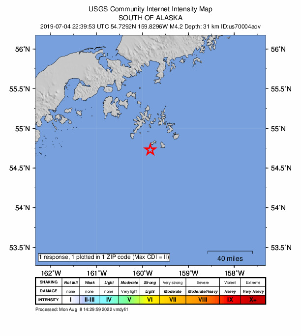
Did you feel it?
1 person reported to the USGS what they felt; the strongest reported shaking was II, weak shaking.
Fault motion and ground failure
How the rock slipped, from the moment tensor, and the USGS estimate of landslides and liquefaction.
- Faulting
- Oblique reverse
- Moment magnitude
- 4.2 Mwr
- Nodal plane 1
- Strike 284°, dip 14°, rake 124°
- Nodal plane 2
- Strike 69°, dip 78°, rake 82°
How well it is located
Reviewed by a seismologist.
- Location uncertainty
- About 3.3 km horizontally, 4.6 km in depth
- Magnitude uncertainty
- ±0.07
- Depth from
- From location
- Station coverage gap
- 157°
- Stations used
- 319
Nearest places
Distance and direction from each place to the epicenter, with its forecast.
Nearby
Within 100 km, magnitude 1.5 and up: 68 in the 60 days after this one and 24 in the 30 days before it.
After
- 2.044 km SE of Sand Point, Alaska · 2644 days ago · 37 km deep · 42 km away
- 2.844 km SW of Sand Point, Alaska · 2644 days ago · 69 km deep · 88 km away
- 2.2134 km ESE of Sand Point, Alaska · 2644 days ago · 30 km deep · 74 km away
- 3.086 km SSE of Sand Point, Alaska · 2644 days ago · 10 km deep · 7 km away
- 2.686 km S of Sand Point, Alaska · 2643 days ago · 34 km deep · 58 km away
- 2.2106 km SSE of Sand Point, Alaska · 2643 days ago · 20 km deep · 37 km away
- 1.9south of Alaska · 2642 days ago · 28 km deep · 11 km away
- 2.1137 km SSE of Sand Point, Alaska · 2642 days ago · 41 km deep · 64 km away
- 2.151 km SSE of Sand Point, Alaska · 2642 days ago · 42 km deep · 29 km away
- 2.297 km S of Sand Point, Alaska · 2641 days ago · 56 km deep · 67 km away
- 2.2south of Alaska · 2641 days ago · 16 km deep · 84 km away
- 2.3115 km SSE of Perryville, Alaska · 2641 days ago · 13 km deep · 81 km away
- 2.233 km SSW of Sand Point, Alaska · 2640 days ago · 94 km deep · 63 km away
- 2.8118 km ESE of Sand Point, Alaska · 2640 days ago · 20 km deep · 62 km away
- 2.560 km ESE of Sand Point, Alaska · 2639 days ago · 28 km deep · 43 km away
- 2.665 km S of Sand Point, Alaska · 2639 days ago · 33 km deep · 42 km away
- 1.9155 km SSE of Sand Point, Alaska · 2637 days ago · 34 km deep · 75 km away
- 2.171 km ESE of Sand Point, Alaska · 2637 days ago · 26 km deep · 50 km away
- 4.2131 km SSE of Perryville, Alaska · 2637 days ago · 24 km deep · 91 km away
- 2.5161 km SSE of Sand Point, Alaska · 2636 days ago · 46 km deep · 81 km away
- 2.897 km ESE of Sand Point, Alaska · 2636 days ago · 21 km deep · 49 km away
- 1.640 km SSW of Ivanof Bay, Alaska · 2635 days ago · 60 km deep · 93 km away
- 2.7100 km SE of Sand Point, Alaska · 2633 days ago · 22 km deep · 22 km away
- 2.654 km S of Ivanof Bay, Alaska · 2631 days ago · 63 km deep · 79 km away
- 2.0149 km SE of Sand Point, Alaska · 2630 days ago · 52 km deep · 70 km away
- 2.2112 km S of Sand Point, Alaska · 2630 days ago · 35 km deep · 51 km away
- 3.383 km SSW of Sand Point, Alaska · 2629 days ago · 35 km deep · 73 km away
- 2.0111 km SE of King Cove, Alaska · 2628 days ago · 36 km deep · 92 km away
- 1.735 km WSW of Sand Point, Alaska · 2628 days ago · 74 km deep · 96 km away
- 1.9106 km SSE of Sand Point, Alaska · 2627 days ago · 60 km deep · 27 km away
- 2.251 km SSW of Sand Point, Alaska · 2627 days ago · 37 km deep · 69 km away
- 2.1103 km S of Sand Point, Alaska · 2626 days ago · 36 km deep · 71 km away
- 2.0132 km SSE of Sand Point, Alaska · 2625 days ago · 51 km deep · 53 km away
- 2.051 km SSE of Sand Point, Alaska · 2625 days ago · 25 km deep · 35 km away
- 1.834 km SE of Sand Point, Alaska · 2622 days ago · 53 km deep · 50 km away
- 2.356 km S of Sand Point, Alaska · 2621 days ago · 41 km deep · 49 km away
- 2.667 km S of Ivanof Bay, Alaska · 2619 days ago · 24 km deep · 70 km away
- 3.066 km S of Sand Point, Alaska · 2619 days ago · 17 km deep · 48 km away
- 2.479 km S of Perryville, Alaska · 2618 days ago · 16 km deep · 68 km away
- 2.4154 km SSE of Sand Point, Alaska · 2618 days ago · 25 km deep · 83 km away
- 1.975 km SSE of Sand Point, Alaska · 2617 days ago · 38 km deep · 4 km away
- 2.172 km SSE of Sand Point, Alaska · 2617 days ago · 3 km deep · 7 km away
- 1.5Alaska Peninsula · 2616 days ago · 66 km deep · 97 km away
- 3.246 km E of Sand Point, Alaska · 2614 days ago · 54 km deep · 64 km away
- 2.6119 km ESE of Sand Point, Alaska · 2613 days ago · 25 km deep · 62 km away
- 1.733 km S of Sand Point, Alaska · 2611 days ago · 13 km deep · 54 km away
- 2.6100 km ESE of Sand Point, Alaska · 2611 days ago · 37 km deep · 55 km away
- 2.577 km SSW of Sand Point, Alaska · 2611 days ago · 24 km deep · 68 km away
- 1.875 km S of Perryville, Alaska · 2608 days ago · 38 km deep · 70 km away
- 2.835 km ENE of Sand Point, Alaska · 2608 days ago · 16 km deep · 85 km away
- 2.4158 km SSE of Sand Point, Alaska · 2606 days ago · 29 km deep · 78 km away
- 2.874 km S of Sand Point, Alaska · 2606 days ago · 21 km deep · 48 km away
- 2.045 km SSW of Ivanof Bay, Alaska · 2604 days ago · 62 km deep · 89 km away
- 1.621 km ESE of Sand Point, Alaska · 2604 days ago · 56 km deep · 64 km away
- 1.754 km S of Perryville, Alaska · 2604 days ago · 42 km deep · 91 km away
- 2.2Alaska Peninsula · 2601 days ago · 16 km deep · 73 km away
- 1.874 km S of Sand Point, Alaska · 2600 days ago · 13 km deep · 42 km away
- 1.842 km S of Ivanof Bay, Alaska · 2600 days ago · 12 km deep · 91 km away
- 2.5176 km SSE of Sand Point, Alaska · 2600 days ago · 33 km deep · 96 km away
- 2.435 km S of Ivanof Bay, Alaska · 2599 days ago · 66 km deep · 98 km away
The first 60 of 68.
Before
- 3.054 km WSW of Sand Point, Alaska · 2645 days ago · 74 km deep · 99 km away
- 2.155 km ESE of Sand Point, Alaska · 2645 days ago · 5 km deep · 42 km away
- 2.350 km SSW of Sand Point, Alaska · 2646 days ago · 38 km deep · 57 km away
- 2.6127 km SSE of Perryville, Alaska · 2647 days ago · 30 km deep · 71 km away
- 2.545 km SW of Sand Point, Alaska · 2647 days ago · 94 km deep · 77 km away
- 2.043 km SE of Sand Point, Alaska · 2647 days ago · 34 km deep · 37 km away
- 1.830 km SSE of Sand Point, Alaska · 2648 days ago · 48 km deep · 49 km away
- 2.144 km SW of Sand Point, Alaska · 2651 days ago · 47 km deep · 77 km away
- 2.374 km ESE of Sand Point, Alaska · 2653 days ago · 26 km deep · 59 km away
- 2.085 km ESE of King Cove, Alaska · 2654 days ago · 17 km deep · 89 km away
- 2.182 km SSW of Sand Point, Alaska · 2654 days ago · 13 km deep · 70 km away
- 1.558 km S of Sand Point, Alaska · 2655 days ago · 26 km deep · 42 km away
- 2.0131 km S of Sand Point, Alaska · 2656 days ago · 46 km deep · 74 km away
- 2.2140 km S of Sand Point, Alaska · 2660 days ago · 35 km deep · 81 km away
- 1.940 km S of Sand Point, Alaska · 2664 days ago · 51 km deep · 54 km away
- 2.823 km E of Sand Point, Alaska · 2665 days ago · 72 km deep · 75 km away
- 3.151 km SSE of Sand Point, Alaska · 2665 days ago · 35 km deep · 33 km away
- 2.652 km ENE of Sand Point, Alaska · 2666 days ago · 21 km deep · 80 km away
- 2.780 km SSE of Sand Point, Alaska · 2669 days ago · 18 km deep · 1 km away
- 2.192 km S of Sand Point, Alaska · 2670 days ago · 51 km deep · 40 km away
Earthquakes todayAlaska earthquakesLive radar here
Sources
From the USGS Earthquake Hazards Program and its partner networks, event us70004adv (also filed as aacse0198ibr7l6, ak0198ibr7l6). Read Wed, Sep 30, 2026, 11:32 AM UTC.