M2.8 earthquake 20 km ESE of Lowell Point, Alaska
A magnitude 2.8 earthquake struck 20 km ESE of Lowell Point, Alaska on Tue, Feb 26, 2019, 9:43 AM AKST (18:43 UTC), 12 km (8 mi) below the surface.
A larger quake followed: M3.0 29 km SSE of Chenega, Alaska. This one was a foreshock.
Map
Where this earthquake was located, with the others nearby. Select one for its page.
The earthquake
- Magnitude
- 2.8 (ML, local (Richter)), micro
- Magnitude from
- Alaska Earthquake Center
- Local time
- UTC
- 2019-02-26 18:43:02 UTC
- Depth
- 12.2 km (7.6 mi), shallow
- Epicenter
- 60.031° N, 149.091° W
- Region
- Alaska
- Felt reports
- 12
- Tsunami flag
- No
- Status
- Reviewed by a seismologist
Magnitude estimates
Different scales measure different things and differ by a few tenths. The USGS marks one as preferred, and it is the one this page uses.
| Mag. | Scale | Computed by | Notes |
|---|---|---|---|
| 2.8 | ML, local (Richter) | Alaska Earthquake Center | Preferred · Preliminary |
| 2.8 | ML, local (Richter) | USGS National Earthquake Information Center | Reviewed |
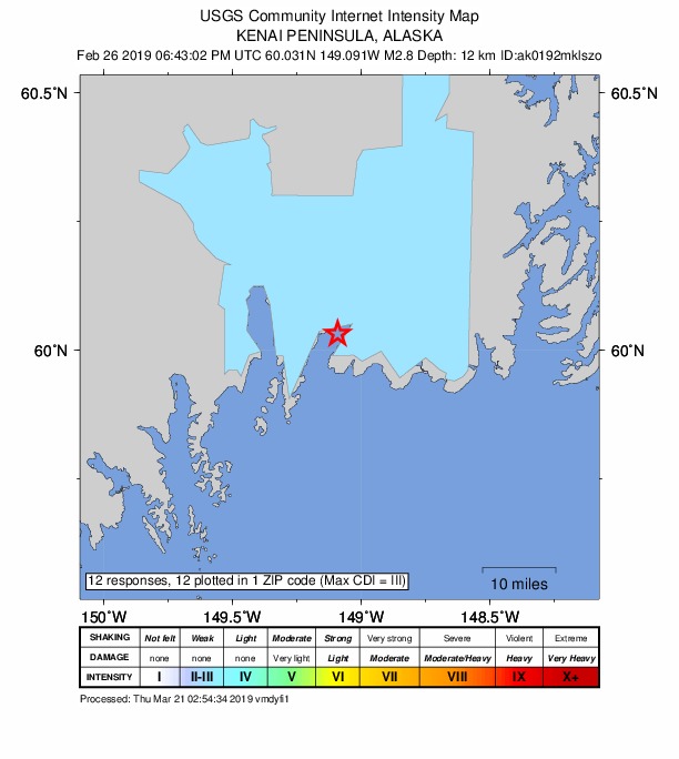
Did you feel it?
12 people reported to the USGS what they felt; the strongest reported shaking was III, weak shaking.
How well it is located
Reviewed by a seismologist.
- Stations used
- 76
Nearest places
Distance and direction from each place to the epicenter, with its forecast.
Nearby
Within 100 km, magnitude 1.5 and up: 46 in the 60 days after this one and 23 in the 30 days before it.
After
- 1.542 km NNE of Chenega, Alaska · 2773 days ago · 16 km deep · 86 km away
- 2.058 km NNE of Chenega, Alaska · 2773 days ago · 10 km deep · 99 km away
- 2.114 km NE of Whittier, Alaska · 2771 days ago · 26 km deep · 98 km away
- 2.012 km NE of Moose Pass, Alaska · 2769 days ago · 21 km deep · 58 km away
- 1.87 km SSW of Cooper Landing, Alaska · 2768 days ago · 32 km deep · 61 km away
- 1.932 km E of Fox River, Alaska · 2766 days ago · 35 km deep · 73 km away
- 1.641 km SE of Chenega, Alaska · 2766 days ago · 2 km deep · 95 km away
- 1.929 km SE of Funny River, Alaska · 2766 days ago · 54 km deep · 80 km away
- 2.424 km NNE of Cooper Landing, Alaska · 2764 days ago · 37 km deep · 79 km away
- 1.756 km NNE of Chenega, Alaska · 2763 days ago · 3 km deep · 97 km away
- 2.927 km ESE of Whittier, Alaska · 2763 days ago · 17 km deep · 86 km away · felt by 1
- 1.736 km SW of Cooper Landing, Alaska · 2762 days ago · 58 km deep · 65 km away
- 2.011 km SE of Funny River, Alaska · 2761 days ago · 41 km deep · 95 km away
- 1.755 km SSE of Lowell Point, Alaska · 2760 days ago · 13 km deep · 48 km away
- 1.723 km SW of Hope, Alaska · 2759 days ago · 39 km deep · 90 km away
- 1.913 km ESE of Chenega, Alaska · 2758 days ago · 16 km deep · 71 km away
- 2.137 km ESE of Lowell Point, Alaska · 2758 days ago · 0 km deep · 17 km away
- 2.235 km WSW of Lowell Point, Alaska · 2757 days ago · 35 km deep · 54 km away
- 1.735 km NNE of Chenega, Alaska · 2757 days ago · 11 km deep · 78 km away
- 1.519 km S of Funny River, Alaska · 2757 days ago · 47 km deep · 99 km away
- 1.79 km NE of Chenega, Alaska · 2754 days ago · 6 km deep · 68 km away
- 1.817 km SSE of Lowell Point, Alaska · 2753 days ago · 8 km deep · 18 km away
- 2.318 km SE of Primrose, Alaska · 2751 days ago · 15 km deep · 24 km away
- 1.79 km ENE of Chenega, Alaska · 2750 days ago · 12 km deep · 69 km away
- 1.930 km ESE of Lowell Point, Alaska · 2750 days ago · 8 km deep · 12 km away
- 1.524 km WSW of Chenega, Alaska · 2746 days ago · 14 km deep · 36 km away
- 2.110 km SSE of Chenega, Alaska · 2745 days ago · 18 km deep · 66 km away
- 1.710 km SSE of Chenega, Alaska · 2745 days ago · 14 km deep · 65 km away
- 1.718 km N of Cooper Landing, Alaska · 2743 days ago · 33 km deep · 82 km away
- 3.029 km SSE of Chenega, Alaska · 2743 days ago · 86 km deep · 76 km away
- 3.020 km SE of Lowell Point, Alaska · 2743 days ago · 1 km deep · 9 km away
- 1.812 km SE of Chenega, Alaska · 2738 days ago · 10 km deep · 69 km away
- 1.95 km ESE of Chenega, Alaska · 2737 days ago · 13 km deep · 65 km away
- 1.66 km E of Chenega, Alaska · 2737 days ago · 11 km deep · 66 km away
- 1.621 km SE of Fox River, Alaska · 2736 days ago · 15 km deep · 99 km away
- 1.757 km NNE of Chenega, Alaska · 2730 days ago · 4 km deep · 98 km away
- 2.811 km SSE of Sunrise, Alaska · 2730 days ago · 28 km deep · 85 km away · felt by 2
- 2.030 km NW of Cooper Landing, Alaska · 2730 days ago · 39 km deep · 96 km away
- 1.518 km NE of Moose Pass, Alaska · 2729 days ago · 14 km deep · 62 km away
- 2.823 km SE of Lowell Point, Alaska · 2723 days ago · 0 km deep · 12 km away
- 1.638 km NNE of Chenega, Alaska · 2722 days ago · 13 km deep · 84 km away
- 1.646 km ESE of Whittier, Alaska · 2722 days ago · 8 km deep · 93 km away
- 1.624 km NNW of Cooper Landing, Alaska · 2720 days ago · 32 km deep · 89 km away
- 1.615 km S of Whittier, Alaska · 2719 days ago · 27 km deep · 71 km away
- 1.519 km E of Lowell Point, Alaska · 2718 days ago · 13 km deep · 2 km away
- 1.531 km SE of Kasilof, Alaska · 2715 days ago · 47 km deep · 97 km away
Before
- 2.37 km W of Cooper Landing, Alaska · 2775 days ago · 40 km deep · 70 km away
- 2.041 km S of Lowell Point, Alaska · 2776 days ago · 10 km deep · 40 km away
- 1.520 km E of Sterling, Alaska · 2777 days ago · 39 km deep · 93 km away
- 1.754 km NNE of Chenega, Alaska · 2782 days ago · 5 km deep · 94 km away
- 2.151 km ESE of Whittier, Alaska · 2786 days ago · 13 km deep · 94 km away
- 2.133 km ESE of Fox River, Alaska · 2787 days ago · 50 km deep · 83 km away
- 2.010 km WNW of Moose Pass, Alaska · 2787 days ago · 27 km deep · 61 km away
- 1.938 km N of Chenega, Alaska · 2789 days ago · 15 km deep · 78 km away
- 1.939 km NNE of Chenega, Alaska · 2791 days ago · 3 km deep · 83 km away
- 1.626 km SW of Cooper Landing, Alaska · 2791 days ago · 34 km deep · 65 km away
- 1.541 km NE of Chenega, Alaska · 2791 days ago · 6 km deep · 93 km away
- 1.723 km WSW of Chenega, Alaska · 2792 days ago · 7 km deep · 41 km away
- 1.643 km NNE of Chenega, Alaska · 2793 days ago · 13 km deep · 88 km away
- 1.643 km NNE of Chenega, Alaska · 2793 days ago · 0 km deep · 92 km away
- 1.546 km NNE of Chenega, Alaska · 2794 days ago · 14 km deep · 89 km away
- 1.534 km E of Lowell Point, Alaska · 2795 days ago · 4 km deep · 15 km away
- 1.543 km NE of Chenega, Alaska · 2797 days ago · 12 km deep · 93 km away
- 1.829 km S of Whittier, Alaska · 2797 days ago · 8 km deep · 57 km away
- 1.632 km WSW of Chenega, Alaska · 2798 days ago · 36 km deep · 36 km away
- 2.117 km S of Funny River, Alaska · 2798 days ago · 56 km deep · 96 km away
Earthquakes todayAlaska earthquakesLive radar here
Sources
From the USGS Earthquake Hazards Program and its partner networks, event ak0192mklszo (also filed as us2000jp30). Read Fri, Oct 2, 2026, 2:56 AM UTC.