M1.6 earthquake 35 km S of Goldfield, Nevada
A magnitude 1.6 earthquake struck 35 km S of Goldfield, Nevada on Tue, Nov 5, 2019, 2:43 PM PST (22:43 UTC), 8 km (5 mi) below the surface.
A larger quake followed: M3.0 53 km S of Silver Peak, Nevada. This one was a foreshock.
Map
Where this earthquake was located, with the others nearby. Select one for its page.
The earthquake
- Magnitude
- 1.6 (ML, local (Richter)), micro
- Magnitude from
- Nevada Seismological Laboratory
- Local time
- UTC
- 2019-11-05 22:43:17 UTC
- Depth
- 8.3 km (5.2 mi), shallow
- Epicenter
- 37.386° N, 117.254° W
- Region
- Nevada
- Felt reports
- 1
- Tsunami flag
- No
- Status
- Reviewed by a seismologist
Did you feel it?
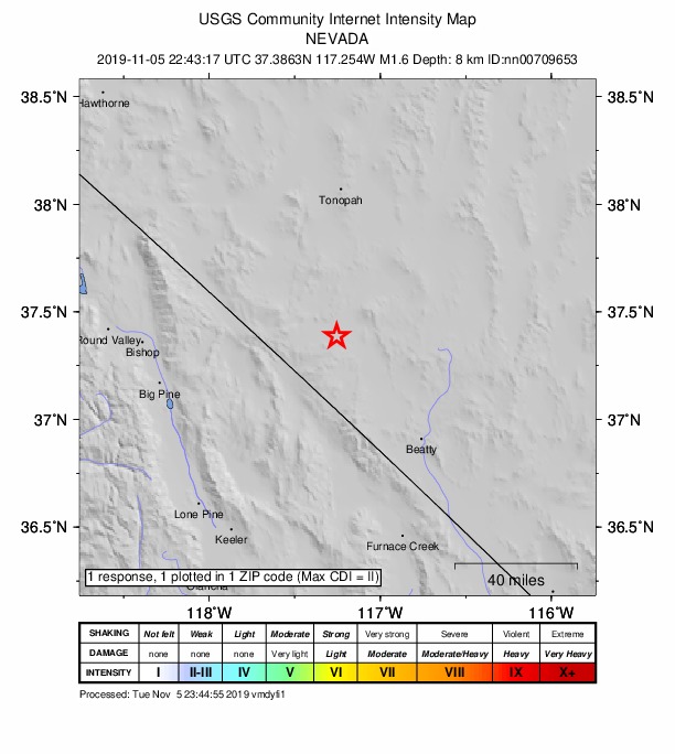
1 person reported to the USGS what they felt; the strongest reported shaking was II, weak shaking.
How well it is located
Reviewed by a seismologist.
- Magnitude uncertainty
- ±0.22
- Station coverage gap
- 92°
- Stations used
- 19
Nearest places
Distance and direction from each place to the epicenter, with its forecast.
Nearby
Within 100 km, magnitude 1.5 and up: 24 in the 60 days after this one and 12 in the 30 days before it.
After
- 1.640 km E of Big Pine, California · 2520 days ago · 7 km deep · 55 km away
- 1.553 km SE of Goldfield, Nevada · 2520 days ago · 15 km deep · 46 km away
- 2.04km NNE of Big Pine, CA · 2510 days ago · 12 km deep · 93 km away
- 1.760km ENE of Big Pine, CA · 2505 days ago · 8 km deep · 35 km away
- 1.663 km SSW of Goldfield, Nevada · 2499 days ago · 6 km deep · 30 km away
- 1.94km SSW of Big Pine, CA · 2495 days ago · 14 km deep · 98 km away
- 1.761 km WNW of Beatty, Nevada · 2494 days ago · 8 km deep · 39 km away
- 1.817 km S of Goldfield, Nevada · 2490 days ago · 0 km deep · 19 km away
- 1.526 km E of Big Pine, California · 2488 days ago · 0 km deep · 71 km away
- 1.952 km WNW of Beatty, Nevada · 2488 days ago · 10 km deep · 24 km away
- 1.552 km S of Silver Peak, Nevada · 2481 days ago · 3 km deep · 38 km away
- 1.740km W of Stovepipe Wells, CA · 2481 days ago · 2 km deep · 98 km away
- 3.053 km S of Silver Peak, Nevada · 2478 days ago · 5 km deep · 34 km away · felt by 1
- 1.750 km S of Silver Peak, Nevada · 2478 days ago · 6 km deep · 33 km away
- 1.751 km S of Silver Peak, Nevada · 2478 days ago · 7 km deep · 33 km away
- 1.548 km S of Silver Peak, Nevada · 2476 days ago · 4 km deep · 32 km away
- 1.660 km SSW of Goldfield, Nevada · 2475 days ago · 6 km deep · 26 km away
- 1.651 km S of Silver Peak, Nevada · 2473 days ago · 6 km deep · 32 km away
- 1.658 km S of Goldfield, Nevada · 2471 days ago · 5 km deep · 24 km away
- 1.655 km S of Silver Peak, Nevada · 2470 days ago · 2 km deep · 35 km away
- 1.939 km S of Silver Peak, Nevada · 2468 days ago · 3 km deep · 29 km away
- 2.435 km S of Goldfield, Nevada · 2468 days ago · 6 km deep · 2 km away
- 2.134 km S of Goldfield, Nevada · 2468 days ago · 5 km deep · 2 km away
- 1.541 km ENE of Independence, California · 2466 days ago · 11 km deep · 67 km away
Before
- 1.638 km ENE of Independence, California · 2529 days ago · 17 km deep · 73 km away
- 1.731km NNW of Deep Springs, CA · 2531 days ago · 4 km deep · 82 km away
- 2.824 km ENE of Benton, California · 2535 days ago · 12 km deep · 99 km away · felt by 2
- 1.751 km SSW of Goldfield, Nevada · 2536 days ago · 8 km deep · 23 km away
- 1.740 km ENE of Big Pine, California · 2540 days ago · 3 km deep · 55 km away
- 2.035 km S of Goldfield, Nevada · 2540 days ago · 1 km deep · 1 km away
- 2.435 km S of Goldfield, Nevada · 2540 days ago · 6 km deep · 1 km away
- 1.935 km SSE of Goldfield, Nevada · 2543 days ago · 0 km deep · 15 km away
- 1.519 km SSW of Silver Peak, Nevada · 2545 days ago · 0 km deep · 47 km away
- 2.834 km S of Goldfield, Nevada · 2548 days ago · 7 km deep · 1 km away
- 1.63 km SE of Wilkerson, California · 2548 days ago · 5 km deep · 99 km away
- 1.85km NW of Big Pine, CA · 2549 days ago · 11 km deep · 97 km away
Earthquakes todayNevada earthquakesLive radar here
Sources
From the USGS Earthquake Hazards Program and its partner networks, event nn00709653. Read Fri, Oct 2, 2026, 2:55 PM UTC.