M1.7 earthquake 18 km SW of Anchor Point, Alaska
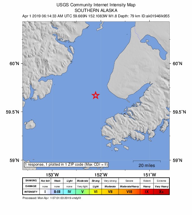
A magnitude 1.7 earthquake struck 18 km SW of Anchor Point, Alaska on Sun, Mar 31, 2019, 10:14 PM AKDT (06:14 UTC), 78 km (49 mi) below the surface.
A larger quake followed: M5.8 61 km SSW of Nanwalek, Alaska. This one was a foreshock.
Map
Where this earthquake was located, with the others nearby. Select one for its page.
The earthquake
- Magnitude
- 1.7 (ML, local (Richter)), micro
- Magnitude from
- Alaska Earthquake Center
- Local time
- UTC
- 2019-04-01 06:14:34 UTC
- Depth
- 78.3 km (48.7 mi), intermediate-depth
- Epicenter
- 59.669° N, 152.084° W
- Region
- Alaska
- Felt reports
- 1
- Tsunami flag
- No
- Status
- Reviewed by a seismologist
Did you feel it?
1 person reported to the USGS what they felt; the strongest reported shaking was II, weak shaking.
How well it is located
Reviewed by a seismologist.
- Stations used
- 47
Nearest places
Distance and direction from each place to the epicenter, with its forecast.
Nearby
Within 100 km, magnitude 1.5 and up: at least 202 in the 60 days after this one and 199 in the 30 days before it.
After
- 1.736 km E of Pedro Bay, Alaska · 2742 days ago · 125 km deep · 79 km away
- 1.944 km E of Pedro Bay, Alaska · 2742 days ago · 124 km deep · 71 km away
- 2.031 km NE of Pedro Bay, Alaska · 2742 days ago · 161 km deep · 98 km away
- 2.051 km NW of Ninilchik, Alaska · 2741 days ago · 85 km deep · 79 km away
- 2.466 km ESE of Pope-Vannoy Landing, Alaska · 2741 days ago · 105 km deep · 92 km away
- 1.839 km ENE of Pedro Bay, Alaska · 2741 days ago · 130 km deep · 80 km away
- 2.138 km ENE of Pedro Bay, Alaska · 2741 days ago · 124 km deep · 85 km away
- 2.133 km NE of Pedro Bay, Alaska · 2741 days ago · 164 km deep · 96 km away
- 2.126 km SE of Pedro Bay, Alaska · 2741 days ago · 152 km deep · 96 km away
- 1.741 km E of Pedro Bay, Alaska · 2740 days ago · 123 km deep · 73 km away
- 2.06 km WNW of Fox River, Alaska · 2740 days ago · 41 km deep · 62 km away
- 2.054 km WNW of Ninilchik, Alaska · 2740 days ago · 85 km deep · 61 km away
- 1.846 km NW of Ninilchik, Alaska · 2740 days ago · 95 km deep · 72 km away
- 1.751 km E of Pedro Bay, Alaska · 2740 days ago · 110 km deep · 63 km away
- 1.666 km WNW of Nanwalek, Alaska · 2740 days ago · 90 km deep · 52 km away
- 1.943 km ESE of Pedro Bay, Alaska · 2740 days ago · 117 km deep · 73 km away
- 2.024 km NNW of Ninilchik, Alaska · 2740 days ago · 68 km deep · 65 km away
- 1.970 km ENE of Port Alsworth, Alaska · 2740 days ago · 145 km deep · 93 km away
- 1.663 km WNW of Nanwalek, Alaska · 2739 days ago · 94 km deep · 50 km away
- 1.663 km ENE of Pedro Bay, Alaska · 2739 days ago · 109 km deep · 69 km away
- 1.532 km WNW of Clam Gulch, Alaska · 2739 days ago · 83 km deep · 80 km away
- 1.623 km SSW of Nanwalek, Alaska · 2739 days ago · 56 km deep · 55 km away
- 2.160 km W of Anchor Point, Alaska · 2739 days ago · 104 km deep · 50 km away
- 2.046 km SW of Nanwalek, Alaska · 2739 days ago · 61 km deep · 70 km away
- 1.660 km ENE of Pedro Bay, Alaska · 2739 days ago · 120 km deep · 76 km away
- 1.762 km ESE of Pedro Bay, Alaska · 2739 days ago · 112 km deep · 53 km away
- 2.054 km E of Pedro Bay, Alaska · 2739 days ago · 106 km deep · 60 km away
- 1.566 km ESE of Pedro Bay, Alaska · 2739 days ago · 87 km deep · 55 km away
- 1.514 km NNW of Anchor Point, Alaska · 2739 days ago · 73 km deep · 25 km away
- 3.364 km ESE of Pope-Vannoy Landing, Alaska · 2739 days ago · 104 km deep · 89 km away
- 1.658 km E of Pedro Bay, Alaska · 2738 days ago · 97 km deep · 55 km away
- 1.673 km SW of Nanwalek, Alaska · 2738 days ago · 65 km deep · 92 km away
- 1.552 km WNW of Anchor Point, Alaska · 2738 days ago · 87 km deep · 46 km away
- 1.762 km ENE of Pedro Bay, Alaska · 2738 days ago · 119 km deep · 68 km away
- 2.435 km ENE of Pedro Bay, Alaska · 2738 days ago · 150 km deep · 89 km away
- 1.960 km WNW of Anchor Point, Alaska · 2738 days ago · 107 km deep · 54 km away
- 1.738 km E of Pedro Bay, Alaska · 2738 days ago · 128 km deep · 75 km away
- 2.217 km N of Fritz Creek, Alaska · 2738 days ago · 45 km deep · 51 km away
- 1.548 km ENE of Pedro Bay, Alaska · 2737 days ago · 131 km deep · 75 km away
- 1.621 km SE of Fox River, Alaska · 2737 days ago · 15 km deep · 76 km away
- 1.753 km W of Nanwalek, Alaska · 2737 days ago · 73 km deep · 54 km away
- 1.835 km W of Anchor Point, Alaska · 2737 days ago · 67 km deep · 24 km away
- 2.158 km WNW of Anchor Point, Alaska · 2737 days ago · 94 km deep · 52 km away · felt by 1
- 3.260 km SE of Pope-Vannoy Landing, Alaska · 2736 days ago · 107 km deep · 99 km away
- 3.260 km SE of Pope-Vannoy Landing, Alaska · 2736 days ago · 104 km deep · 99 km away
- 1.958 km ENE of Pedro Bay, Alaska · 2736 days ago · 127 km deep · 76 km away
- 1.968 km W of Nanwalek, Alaska · 2736 days ago · 93 km deep · 72 km away
- 1.818 km W of Anchor Point, Alaska · 2736 days ago · 65 km deep · 15 km away
- 1.945 km E of Pedro Bay, Alaska · 2736 days ago · 120 km deep · 71 km away
- 1.551 km WNW of Happy Valley, Alaska · 2735 days ago · 83 km deep · 56 km away
- 2.160 km WNW of Anchor Point, Alaska · 2735 days ago · 88 km deep · 55 km away · felt by 1
- 1.758 km NE of Pedro Bay, Alaska · 2734 days ago · 131 km deep · 82 km away
- 2.061 km W of Anchor Point, Alaska · 2734 days ago · 102 km deep · 51 km away
- 1.567 km NW of Ninilchik, Alaska · 2734 days ago · 115 km deep · 89 km away
- 1.858 km WNW of Anchor Point, Alaska · 2734 days ago · 89 km deep · 50 km away
- 1.625 km ESE of Pedro Bay, Alaska · 2734 days ago · 127 km deep · 91 km away
- 1.659 km WNW of Anchor Point, Alaska · 2734 days ago · 102 km deep · 51 km away
- 1.556 km ESE of Pedro Bay, Alaska · 2733 days ago · 113 km deep · 59 km away
- 1.569 km E of Port Alsworth, Alaska · 2733 days ago · 128 km deep · 92 km away
- 1.536 km E of Pedro Bay, Alaska · 2733 days ago · 121 km deep · 78 km away
The first 60 of at least 202.
Before
- 1.812 km SSE of Fox River, Alaska · 2742 days ago · 35 km deep · 69 km away
- 1.558 km E of Pedro Bay, Alaska · 2743 days ago · 104 km deep · 56 km away
- 2.524 km WNW of Ninilchik, Alaska · 2743 days ago · 64 km deep · 51 km away
- 1.620 km SSE of Clam Gulch, Alaska · 2743 days ago · 61 km deep · 62 km away
- 2.962 km E of Pedro Bay, Alaska · 2743 days ago · 109 km deep · 53 km away
- 1.656 km ESE of Pope-Vannoy Landing, Alaska · 2743 days ago · 108 km deep · 94 km away
- 1.860 km E of Port Alsworth, Alaska · 2744 days ago · 136 km deep · 91 km away
- 1.569 km W of Happy Valley, Alaska · 2744 days ago · 112 km deep · 65 km away
- 1.66 km N of Fox River, Alaska · 2745 days ago · 57 km deep · 68 km away
- 1.764 km ESE of Pedro Bay, Alaska · 2745 days ago · 90 km deep · 55 km away
- 1.866 km E of Port Alsworth, Alaska · 2745 days ago · 126 km deep · 80 km away
- 1.755 km E of Pedro Bay, Alaska · 2745 days ago · 104 km deep · 59 km away
- 1.610 km E of Ninilchik, Alaska · 2745 days ago · 64 km deep · 53 km away
- 1.562 km WNW of Anchor Point, Alaska · 2745 days ago · 120 km deep · 53 km away
- 1.642 km ENE of Pedro Bay, Alaska · 2746 days ago · 126 km deep · 76 km away
- 1.67 km SE of Ninilchik, Alaska · 2746 days ago · 59 km deep · 47 km away
- 1.559 km ENE of Pedro Bay, Alaska · 2746 days ago · 122 km deep · 72 km away
- 1.638 km ENE of Pedro Bay, Alaska · 2747 days ago · 148 km deep · 87 km away
- 1.758 km W of Nanwalek, Alaska · 2747 days ago · 104 km deep · 55 km away
- 1.670 km WNW of Happy Valley, Alaska · 2747 days ago · 113 km deep · 68 km away
Earthquakes todayAlaska earthquakesLive radar here
Sources
From the USGS Earthquake Hazards Program and its partner networks, event ak01946lk955. Read Sat, Oct 3, 2026, 1:29 PM UTC.