M3.5 earthquake 51 km S of Adak, Alaska
A magnitude 3.5 earthquake struck 51 km S of Adak, Alaska on Thu, Aug 29, 2019, 1:16 PM HADT (22:16 UTC), 45 km (28 mi) below the surface.
A larger quake followed: M4.0 59 km SE of Adak, Alaska. This one was a foreshock.
Map
Where this earthquake was located, with the others nearby. Select one for its page.
The earthquake
- Magnitude
- 3.5 (mb, body-wave), minor
- Magnitude from
- USGS National Earthquake Information Center
- Local time
- UTC
- 2019-08-29 22:16:42 UTC
- Depth
- 45.4 km (28.2 mi), shallow
- Epicenter
- 51.411° N, 176.724° W
- Region
- Alaska
- Felt reports
- 1
- Tsunami flag
- No
- Status
- Reviewed by a seismologist
Magnitude estimates
Different scales measure different things and differ by a few tenths. The USGS marks one as preferred, and it is the one this page uses.
| Mag. | Scale | Computed by | Notes |
|---|---|---|---|
| 3.5 | mb, body-wave | USGS National Earthquake Information Center | Preferred · Reviewed · ±0.093 · 28 stations |
| 3.5 | ML, local (Richter) | Alaska Earthquake Center | Preliminary |
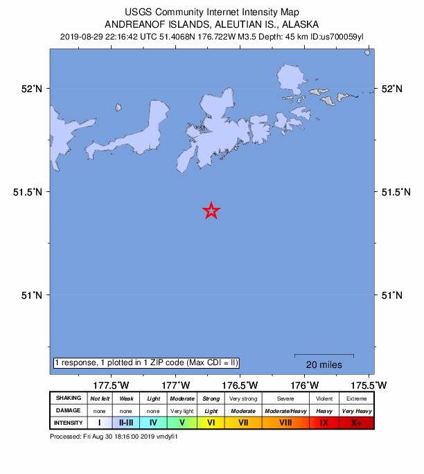
Did you feel it?
1 person reported to the USGS what they felt; the strongest reported shaking was II, weak shaking.
How well it is located
Reviewed by a seismologist.
- Location uncertainty
- About 6.2 km horizontally, 17.6 km in depth
- Magnitude uncertainty
- ±0.09
- Depth from
- From location
- Station coverage gap
- 202°, poorly surrounded by stations
- Stations used
- 32
Nearby
Within 100 km, magnitude 1.5 and up: 135 in the 60 days after this one and 69 in the 30 days before it.
After
- 2.447 km S of Adak, Alaska · 2590 days ago · 35 km deep · 5 km away
- 1.898 km S of Adak, Alaska · 2590 days ago · 42 km deep · 47 km away
- 1.984 km ESE of Adak, Alaska · 2590 days ago · 47 km deep · 92 km away
- 1.753 km SSE of Adak, Alaska · 2590 days ago · 28 km deep · 18 km away
- 1.9125 km SW of Adak, Alaska · 2589 days ago · 40 km deep · 83 km away
- 3.381 km SE of Adak, Alaska · 2589 days ago · 10 km deep · 71 km away
- 1.559 km SE of Adak, Alaska · 2585 days ago · 26 km deep · 41 km away
- 2.049 km ESE of Adak, Alaska · 2584 days ago · 46 km deep · 54 km away
- 2.156 km SSW of Adak, Alaska · 2584 days ago · 45 km deep · 7 km away
- 1.633 km E of Adak, Alaska · 2584 days ago · 69 km deep · 62 km away
- 1.672 km SSE of Adak, Alaska · 2584 days ago · 26 km deep · 35 km away
- 1.6102 km SW of Adak, Alaska · 2583 days ago · 47 km deep · 76 km away
- 1.611 km NE of Adak, Alaska · 2583 days ago · 104 km deep · 61 km away
- 2.130 km SSE of Adak, Alaska · 2583 days ago · 49 km deep · 32 km away
- 1.5126 km SW of Adak, Alaska · 2583 days ago · 13 km deep · 96 km away
- 1.728 km ENE of Adak, Alaska · 2582 days ago · 79 km deep · 71 km away
- 1.539 km SSE of Adak, Alaska · 2582 days ago · 35 km deep · 29 km away
- 1.9117 km WSW of Adak, Alaska · 2582 days ago · 26 km deep · 98 km away
- 1.555 km S of Adak, Alaska · 2581 days ago · 21 km deep · 10 km away
- 1.736 km SW of Adak, Alaska · 2581 days ago · 64 km deep · 36 km away
- 1.572 km SSE of Adak, Alaska · 2580 days ago · 20 km deep · 36 km away
- 1.571 km SSE of Adak, Alaska · 2580 days ago · 21 km deep · 33 km away
- 1.8112 km SW of Adak, Alaska · 2580 days ago · 25 km deep · 75 km away
- 2.480 km SW of Adak, Alaska · 2579 days ago · 44 km deep · 61 km away
- 1.828 km NW of Adak, Alaska · 2579 days ago · 191 km deep · 74 km away
- 1.7102 km SW of Adak, Alaska · 2579 days ago · 46 km deep · 78 km away
- 2.040 km SSW of Adak, Alaska · 2578 days ago · 58 km deep · 19 km away
- 2.1128 km SW of Adak, Alaska · 2578 days ago · 26 km deep · 100 km away
- 2.146 km S of Adak, Alaska · 2578 days ago · 34 km deep · 9 km away
- 1.965 km WSW of Adak, Alaska · 2577 days ago · 20 km deep · 70 km away
- 4.059 km SE of Adak, Alaska · 2577 days ago · 42 km deep · 46 km away
- 2.199 km SW of Adak, Alaska · 2577 days ago · 47 km deep · 76 km away
- 2.4104 km SW of Adak, Alaska · 2577 days ago · 39 km deep · 72 km away
- 2.167 km WSW of Adak, Alaska · 2576 days ago · 39 km deep · 54 km away
- 1.752 km SSE of Adak, Alaska · 2575 days ago · 28 km deep · 18 km away
- 2.2Andreanof Islands, Aleutian Islands, Alaska · 2575 days ago · 58 km deep · 31 km away
- 1.784 km W of Adak, Alaska · 2575 days ago · 6 km deep · 93 km away
- 2.353 km SW of Adak, Alaska · 2573 days ago · 37 km deep · 25 km away
- 1.980 km SE of Adak, Alaska · 2573 days ago · 7 km deep · 69 km away
- 2.644 km E of Adak, Alaska · 2573 days ago · 97 km deep · 77 km away
- 2.789 km SSE of Adak, Alaska · 2572 days ago · 22 km deep · 52 km away
- 2.129 km SSW of Adak, Alaska · 2571 days ago · 62 km deep · 24 km away
- 2.9119 km WSW of Adak, Alaska · 2571 days ago · 35 km deep · 97 km away
- 2.893 km SW of Adak, Alaska · 2571 days ago · 40 km deep · 68 km away
- 2.0110 km SW of Adak, Alaska · 2571 days ago · 26 km deep · 79 km away
- 1.577 km SW of Adak, Alaska · 2571 days ago · 47 km deep · 55 km away
- 1.777 km SW of Adak, Alaska · 2570 days ago · 38 km deep · 51 km away
- 2.699 km SW of Adak, Alaska · 2570 days ago · 35 km deep · 69 km away
- 2.065 km SE of Adak, Alaska · 2570 days ago · 46 km deep · 52 km away
- 1.665 km SSE of Adak, Alaska · 2568 days ago · 26 km deep · 27 km away
- 1.667 km SSE of Adak, Alaska · 2568 days ago · 28 km deep · 25 km away
- 1.962 km SSE of Adak, Alaska · 2568 days ago · 30 km deep · 38 km away
- 2.896 km WSW of Adak, Alaska · 2568 days ago · 64 km deep · 83 km away
- 2.126 km SSW of Adak, Alaska · 2568 days ago · 58 km deep · 27 km away
- 2.568 km SE of Adak, Alaska · 2568 days ago · 35 km deep · 48 km away
- 2.338 km S of Adak, Alaska · 2568 days ago · 38 km deep · 14 km away
- 2.352 km SSE of Adak, Alaska · 2567 days ago · 21 km deep · 24 km away
- 2.519 km ESE of Adak, Alaska · 2567 days ago · 103 km deep · 48 km away
- 1.966 km SE of Adak, Alaska · 2566 days ago · 24 km deep · 60 km away
- 3.945 km SE of Adak, Alaska · 2565 days ago · 47 km deep · 46 km away
The first 60 of 135.
Before
- 2.6136 km SSW of Adak, Alaska · 2590 days ago · 10 km deep · 93 km away
- 2.5136 km SSW of Adak, Alaska · 2590 days ago · 10 km deep · 92 km away
- 1.569 km SSW of Adak, Alaska · 2590 days ago · 26 km deep · 23 km away
- 1.662 km SW of Adak, Alaska · 2592 days ago · 43 km deep · 35 km away
- 1.633 km S of Adak, Alaska · 2592 days ago · 39 km deep · 18 km away
- 1.5113 km WSW of Adak, Alaska · 2593 days ago · 13 km deep · 99 km away
- 2.172 km SE of Adak, Alaska · 2593 days ago · 35 km deep · 60 km away
- 1.679 km WSW of Adak, Alaska · 2594 days ago · 77 km deep · 75 km away
- 1.655 km SSE of Adak, Alaska · 2594 days ago · 23 km deep · 32 km away
- 1.763 km SE of Adak, Alaska · 2594 days ago · 26 km deep · 46 km away
- 1.9127 km SW of Adak, Alaska · 2594 days ago · 28 km deep · 99 km away
- 1.9111 km WSW of Adak, Alaska · 2595 days ago · 10 km deep · 99 km away
- 1.869 km SSW of Adak, Alaska · 2596 days ago · 29 km deep · 28 km away
- 2.275 km SW of Adak, Alaska · 2596 days ago · 33 km deep · 57 km away
- 2.580 km ESE of Adak, Alaska · 2597 days ago · 35 km deep · 90 km away
- 1.6105 km SW of Adak, Alaska · 2597 days ago · 36 km deep · 66 km away
- 1.9109 km SW of Adak, Alaska · 2598 days ago · 27 km deep · 78 km away
- 1.672 km SW of Adak, Alaska · 2599 days ago · 44 km deep · 50 km away
- 1.847 km S of Adak, Alaska · 2599 days ago · 49 km deep · 7 km away
- 1.834 km SSE of Adak, Alaska · 2600 days ago · 50 km deep · 34 km away
Earthquakes todayAlaska earthquakesLive radar here
Sources
From the USGS Earthquake Hazards Program and its partner networks, event us700059yl (also filed as ak019b2xpoba). Read Fri, Oct 2, 2026, 2:32 AM UTC.