M4.6 earthquake 16 km E of Unalaska, Alaska
A magnitude 4.6 earthquake struck 16 km E of Unalaska, Alaska on Thu, Nov 15, 2018, 9:13 AM AKST (18:13 UTC), 84 km (52 mi) below the surface.
Map
Where this earthquake was located, with the others nearby. Select one for its page.
The earthquake
- Magnitude
- 4.6 (mb), light
- Local time
- UTC
- 2018-11-15 18:13:25 UTC
- Depth
- 84.0 km (52.2 mi), intermediate-depth
- Epicenter
- 53.861° N, 166.283° W
- Region
- Alaska
- Felt reports
- 3
- Tsunami flag
- No
- Status
- Reviewed by a seismologist
Did you feel it?
3 people reported to the USGS what they felt; the strongest reported shaking was III, weak shaking.
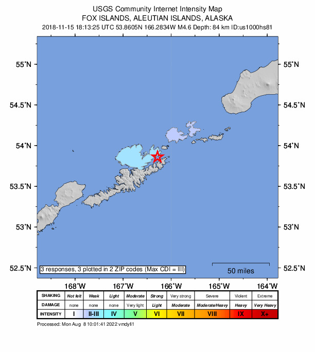
How well it is located
Reviewed by a seismologist.
- Location uncertainty
- About 4.0 km horizontally, 4.1 km in depth
- Magnitude uncertainty
- ±0.04
- Depth from
- From location
- Station coverage gap
- 144°
- Stations used
- 95
Nearest places
Distance and direction from each place to the epicenter, with its forecast.
Nearby
Within 100 km, magnitude 1.6 and up: 67 in the 60 days after this one and 41 in the 30 days before it.
After
- 1.934 km SE of Unalaska, Alaska · 2876 days ago · 71 km deep · 22 km away
- 2.330 km SE of Unalaska, Alaska · 2876 days ago · 70 km deep · 18 km away
- 1.830 km ESE of Unalaska, Alaska · 2875 days ago · 72 km deep · 16 km away
- 2.070 km SE of Unalaska, Alaska · 2874 days ago · 13 km deep · 58 km away
- 1.790 km SSW of Unalaska, Alaska · 2871 days ago · 23 km deep · 97 km away
- 1.792 km SSW of Unalaska, Alaska · 2871 days ago · 13 km deep · 97 km away
- 2.467 km SE of Akutan, Alaska · 2870 days ago · 38 km deep · 81 km away
- 2.153 km SSE of Akutan, Alaska · 2869 days ago · 47 km deep · 54 km away
- 2.277 km SSE of Akutan, Alaska · 2869 days ago · 50 km deep · 76 km away
- 1.960 km WSW of Unalaska, Alaska · 2867 days ago · 2 km deep · 75 km away
- 1.879 km SSE of Akutan, Alaska · 2867 days ago · 17 km deep · 73 km away
- 1.953 km SE of Akutan, Alaska · 2866 days ago · 24 km deep · 70 km away
- 2.774 km S of Akutan, Alaska · 2865 days ago · 20 km deep · 61 km away
- 2.591 km SE of Unalaska, Alaska · 2864 days ago · 25 km deep · 80 km away
- 2.261 km SE of Akutan, Alaska · 2863 days ago · 56 km deep · 80 km away
- 1.977 km SE of Unalaska, Alaska · 2863 days ago · 20 km deep · 66 km away
- 1.866 km SE of Unalaska, Alaska · 2863 days ago · 23 km deep · 54 km away
- 1.865 km SE of Unalaska, Alaska · 2862 days ago · 22 km deep · 54 km away
- 1.8Fox Islands, Aleutian Islands, Alaska · 2862 days ago · 26 km deep · 79 km away
- 2.236 km ESE of Unalaska, Alaska · 2861 days ago · 38 km deep · 22 km away
- 1.846 km SSE of Akutan, Alaska · 2858 days ago · 54 km deep · 50 km away
- 2.053 km SW of Unalaska, Alaska · 2856 days ago · 86 km deep · 64 km away
- 2.955 km ESE of Akutan, Alaska · 2856 days ago · 70 km deep · 84 km away
- 3.378 km SSW of Unalaska, Alaska · 2855 days ago · 48 km deep · 83 km away
- 1.973 km SW of Unalaska, Alaska · 2854 days ago · 15 km deep · 84 km away
- 2.248 km S of Akutan, Alaska · 2853 days ago · 50 km deep · 43 km away
- 2.382 km SSE of Akutan, Alaska · 2853 days ago · 14 km deep · 80 km away
- 1.983 km SSE of Akutan, Alaska · 2853 days ago · 23 km deep · 82 km away
- 3.588 km SSW of Unalaska, Alaska · 2852 days ago · 33 km deep · 94 km away
- 2.388 km SSW of Unalaska, Alaska · 2852 days ago · 26 km deep · 93 km away
- 1.78 km SW of Unalaska, Alaska · 2851 days ago · 12 km deep · 24 km away
- 3.458 km SE of Akutan, Alaska · 2850 days ago · 58 km deep · 68 km away
- 2.467 km S of Unalaska, Alaska · 2849 days ago · 37 km deep · 68 km away
- 4.078 km S of Unalaska, Alaska · 2849 days ago · 10 km deep · 82 km away
- 2.034 km S of Akutan, Alaska · 2849 days ago · 30 km deep · 33 km away
- 2.181 km SSW of Unalaska, Alaska · 2849 days ago · 25 km deep · 86 km away
- 2.246 km S of Akutan, Alaska · 2848 days ago · 61 km deep · 37 km away
- 2.136 km SE of Akutan, Alaska · 2848 days ago · 64 km deep · 62 km away
- 2.128 km NE of Dutch Harbor, Alaska · 2845 days ago · 118 km deep · 21 km away
- 3.389 km S of Unalaska, Alaska · 2844 days ago · 24 km deep · 93 km away
- 2.684 km S of Unalaska, Alaska · 2844 days ago · 27 km deep · 88 km away
- 2.460 km S of Unalaska, Alaska · 2844 days ago · 39 km deep · 58 km away
- 2.869 km SE of Unalaska, Alaska · 2843 days ago · 40 km deep · 56 km away
- 2.342 km SW of Unalaska, Alaska · 2841 days ago · 13 km deep · 55 km away
- 2.778 km S of Unalaska, Alaska · 2841 days ago · 26 km deep · 80 km away
- 2.747 km N of Akutan, Alaska · 2839 days ago · 153 km deep · 82 km away
- 2.672 km SSE of Unalaska, Alaska · 2837 days ago · 26 km deep · 70 km away
- 2.451 km SW of Unalaska, Alaska · 2837 days ago · 13 km deep · 64 km away
- 2.184 km SSE of Akutan, Alaska · 2837 days ago · 19 km deep · 78 km away
- 2.157 km SE of Unalaska, Alaska · 2836 days ago · 46 km deep · 46 km away
- 1.862 km SE of Unalaska, Alaska · 2834 days ago · 47 km deep · 51 km away
- 2.978 km SSW of Unalaska, Alaska · 2834 days ago · 15 km deep · 82 km away
- 2.074 km SW of Unalaska, Alaska · 2833 days ago · 71 km deep · 88 km away
- 2.879 km SE of Akutan, Alaska · 2833 days ago · 42 km deep · 99 km away
- 2.375 km S of Unalaska, Alaska · 2831 days ago · 21 km deep · 78 km away
- 2.354 km S of Akutan, Alaska · 2830 days ago · 51 km deep · 41 km away
- 1.970 km ESE of Akutan, Alaska · 2826 days ago · 48 km deep · 93 km away
- 2.561 km SE of Unalaska, Alaska · 2826 days ago · 30 km deep · 48 km away
- 2.947 km SE of Unalaska, Alaska · 2825 days ago · 35 km deep · 35 km away
- 1.761 km SE of Unalaska, Alaska · 2825 days ago · 34 km deep · 48 km away
The first 60 of 67.
Before
- 2.087 km SSW of Unalaska, Alaska · 2877 days ago · 14 km deep · 92 km away
- 2.172 km ESE of Akutan, Alaska · 2878 days ago · 61 km deep · 96 km away
- 1.962 km S of Akutan, Alaska · 2879 days ago · 40 km deep · 50 km away
- 2.318 km WSW of Dutch Harbor, Alaska · 2880 days ago · 8 km deep · 35 km away
- 1.618 km WSW of Dutch Harbor, Alaska · 2881 days ago · 6 km deep · 34 km away
- 1.820 km W of Dutch Harbor, Alaska · 2881 days ago · 6 km deep · 37 km away
- 1.720 km WSW of Dutch Harbor, Alaska · 2881 days ago · 5 km deep · 37 km away
- 1.979 km SSE of Akutan, Alaska · 2881 days ago · 6 km deep · 77 km away
- 2.769 km SSE of Akutan, Alaska · 2882 days ago · 35 km deep · 65 km away
- 2.276 km SSE of Akutan, Alaska · 2882 days ago · 50 km deep · 75 km away
- 2.890 km SSE of Akutan, Alaska · 2882 days ago · 27 km deep · 88 km away
- 3.687 km SSE of Akutan, Alaska · 2882 days ago · 27 km deep · 85 km away
- 2.662 km SSE of Unalaska, Alaska · 2884 days ago · 28 km deep · 57 km away
- 2.127 km S of Unalaska, Alaska · 2886 days ago · 75 km deep · 32 km away
- 2.087 km S of Unalaska, Alaska · 2886 days ago · 20 km deep · 88 km away
- 2.043 km SE of Akutan, Alaska · 2886 days ago · 24 km deep · 59 km away
- 2.152 km SW of Unalaska, Alaska · 2888 days ago · 17 km deep · 66 km away
- 2.541 km ESE of Unalaska, Alaska · 2891 days ago · 70 km deep · 27 km away
- 2.399 km SSE of Akutan, Alaska · 2893 days ago · 39 km deep · 95 km away
- 1.841 km S of Akutan, Alaska · 2893 days ago · 95 km deep · 31 km away
Earthquakes todayAlaska earthquakesLive radar here
Sources
From the USGS Earthquake Hazards Program and its partner networks, event us1000hs81 (also filed as ak20362290, ak018env8cpq). Read Wed, Sep 30, 2026, 1:55 PM UTC.