M4.4 earthquake 89 km E of Nikolski, Alaska
A magnitude 4.4 earthquake struck 89 km E of Nikolski, Alaska on Thu, May 17, 2018, 11:41 AM AKDT (19:41 UTC), 47 km (29 mi) below the surface.
A larger quake followed: M4.6 135 km S of Unalaska, Alaska. This one was a foreshock.
Map
Where this earthquake was located, with the others nearby. Select one for its page.
The earthquake
- Magnitude
- 4.4 (mb, body-wave), light
- Magnitude from
- USGS National Earthquake Information Center
- Local time
- UTC
- 2018-05-17 19:41:11 UTC
- Depth
- 47.2 km (29.3 mi), shallow
- Epicenter
- 52.951° N, 167.530° W
- Region
- Alaska
- Felt reports
- 1
- Tsunami flag
- No
- Status
- Reviewed by a seismologist
Magnitude estimates
Different scales measure different things and differ by a few tenths. The USGS marks one as preferred, and it is the one this page uses.
| Mag. | Scale | Computed by | Notes |
|---|---|---|---|
| 4.4 | mb, body-wave | USGS National Earthquake Information Center | Preferred · Reviewed · ±0.047 · 129 stations |
| 4.4 | mb, body-wave | Alaska Earthquake Center | Preliminary |
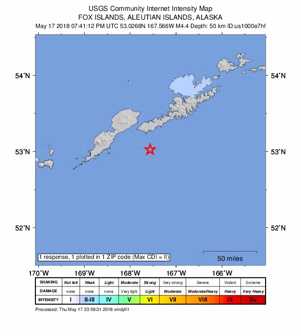
Did you feel it?
1 person reported to the USGS what they felt; the strongest reported shaking was II, weak shaking.
How well it is located
Reviewed by a seismologist.
- Location uncertainty
- About 5.3 km horizontally, 3.1 km in depth
- Magnitude uncertainty
- ±0.05
- Depth from
- From location
- Station coverage gap
- 171°
- Stations used
- 97
Nearest places
Distance and direction from each place to the epicenter, with its forecast.
Nearby
Within 100 km, magnitude 1.5 and up: 60 in the 60 days after this one and 34 in the 30 days before it.
After
- 2.897 km E of Nikolski, Alaska · 3059 days ago · 22 km deep · 11 km away
- 4.495 km E of Nikolski, Alaska · 3058 days ago · 47 km deep · 6 km away
- 2.375 km ESE of Nikolski, Alaska · 3058 days ago · 26 km deep · 32 km away
- 2.067 km SW of Unalaska, Alaska · 3056 days ago · 8 km deep · 60 km away
- 1.735 km SSW of Unalaska, Alaska · 3052 days ago · 81 km deep · 87 km away
- 2.270 km S of Unalaska, Alaska · 3052 days ago · 42 km deep · 63 km away
- 1.935 km ESE of Nikolski, Alaska · 3052 days ago · 47 km deep · 57 km away
- 3.393 km SSW of Unalaska, Alaska · 3051 days ago · 19 km deep · 40 km away
- 3.327 km ESE of Nikolski, Alaska · 3049 days ago · 35 km deep · 68 km away
- 1.858 km SW of Unalaska, Alaska · 3046 days ago · 16 km deep · 67 km away
- 3.953 km SSE of Unalaska, Alaska · 3046 days ago · 41 km deep · 93 km away
- 3.9119 km E of Nikolski, Alaska · 3045 days ago · 47 km deep · 35 km away
- 3.570 km ENE of Nikolski, Alaska · 3043 days ago · 70 km deep · 26 km away
- 2.880 km S of Unalaska, Alaska · 3042 days ago · 41 km deep · 59 km away
- 2.065 km SW of Unalaska, Alaska · 3042 days ago · 98 km deep · 63 km away
- 1.927 km SSE of Nikolski, Alaska · 3039 days ago · 33 km deep · 80 km away
- 1.770 km SW of Unalaska, Alaska · 3039 days ago · 22 km deep · 57 km away
- 3.071 km S of Unalaska, Alaska · 3036 days ago · 49 km deep · 62 km away
- 2.692 km S of Unalaska, Alaska · 3036 days ago · 10 km deep · 63 km away
- 1.974 km E of Nikolski, Alaska · 3035 days ago · 35 km deep · 15 km away
- 3.570 km S of Unalaska, Alaska · 3035 days ago · 47 km deep · 87 km away
- 2.075 km S of Unalaska, Alaska · 3034 days ago · 19 km deep · 61 km away
- 1.853 km SW of Unalaska, Alaska · 3033 days ago · 14 km deep · 73 km away
- 2.1113 km SSW of Unalaska, Alaska · 3032 days ago · 10 km deep · 29 km away
- 1.953 km SW of Unalaska, Alaska · 3032 days ago · 18 km deep · 73 km away
- 1.652 km SW of Unalaska, Alaska · 3032 days ago · 15 km deep · 72 km away
- 1.750 km ESE of Nikolski, Alaska · 3032 days ago · 31 km deep · 52 km away
- 1.885 km SE of Nikolski, Alaska · 3032 days ago · 42 km deep · 74 km away
- 1.555 km SW of Unalaska, Alaska · 3031 days ago · 14 km deep · 72 km away
- 2.161 km SW of Unalaska, Alaska · 3028 days ago · 13 km deep · 69 km away
- 1.738 km SW of Unalaska, Alaska · 3028 days ago · 15 km deep · 85 km away
- 2.791 km SSW of Unalaska, Alaska · 3028 days ago · 29 km deep · 36 km away
- 2.489 km SSW of Unalaska, Alaska · 3028 days ago · 26 km deep · 38 km away
- 1.887 km SSW of Unalaska, Alaska · 3028 days ago · 26 km deep · 47 km away
- 2.391 km SW of Unalaska, Alaska · 3027 days ago · 33 km deep · 33 km away
- 2.188 km SW of Unalaska, Alaska · 3027 days ago · 9 km deep · 37 km away
- 2.771 km ENE of Nikolski, Alaska · 3027 days ago · 55 km deep · 29 km away
- 2.2102 km E of Nikolski, Alaska · 3025 days ago · 46 km deep · 13 km away
- 2.152 km SSE of Unalaska, Alaska · 3023 days ago · 48 km deep · 93 km away
- 1.636 km SW of Unalaska, Alaska · 3022 days ago · 10 km deep · 86 km away
- 2.275 km SSW of Unalaska, Alaska · 3021 days ago · 26 km deep · 57 km away
- 2.8158 km ESE of Nikolski, Alaska · 3021 days ago · 10 km deep · 84 km away
- 2.370 km SW of Unalaska, Alaska · 3020 days ago · 66 km deep · 53 km away
- 2.291 km SSW of Unalaska, Alaska · 3018 days ago · 26 km deep · 39 km away
- 1.691 km SSW of Unalaska, Alaska · 3015 days ago · 26 km deep · 33 km away
- 2.165 km SE of Nikolski, Alaska · 3010 days ago · 26 km deep · 65 km away
- 3.574 km S of Unalaska, Alaska · 3009 days ago · 28 km deep · 61 km away
- 1.988 km ENE of Nikolski, Alaska · 3009 days ago · 26 km deep · 40 km away
- 2.068 km SW of Unalaska, Alaska · 3008 days ago · 13 km deep · 59 km away
- 4.6135 km S of Unalaska, Alaska · 3007 days ago · 32 km deep · 78 km away
- 3.691 km SSW of Unalaska, Alaska · 3005 days ago · 28 km deep · 37 km away
- 2.595 km SSW of Unalaska, Alaska · 3005 days ago · 19 km deep · 36 km away
- 1.967 km S of Unalaska, Alaska · 3004 days ago · 26 km deep · 81 km away
- 2.567 km S of Unalaska, Alaska · 3001 days ago · 86 km deep · 71 km away
- 3.783 km SE of Nikolski, Alaska · 3000 days ago · 10 km deep · 68 km away
- 1.634 km SW of Unalaska, Alaska · 3000 days ago · 16 km deep · 89 km away
- 3.3148 km SE of Nikolski, Alaska · 3000 days ago · 28 km deep · 94 km away
- 1.963 km SSE of Unalaska, Alaska · 3000 days ago · 26 km deep · 96 km away
- 1.835 km SW of Unalaska, Alaska · 3000 days ago · 15 km deep · 87 km away
- 1.967 km SSW of Unalaska, Alaska · 2999 days ago · 47 km deep · 63 km away
Before
- 2.082 km SE of Nikolski, Alaska · 3064 days ago · 15 km deep · 70 km away
- 2.079 km SSW of Unalaska, Alaska · 3064 days ago · 26 km deep · 53 km away
- 2.070 km SE of Nikolski, Alaska · 3065 days ago · 17 km deep · 51 km away
- 1.999 km E of Nikolski, Alaska · 3065 days ago · 47 km deep · 10 km away
- 1.839 km SSW of Unalaska, Alaska · 3066 days ago · 75 km deep · 85 km away
- 2.848 km ESE of Nikolski, Alaska · 3066 days ago · 35 km deep · 43 km away
- 1.675 km SW of Unalaska, Alaska · 3067 days ago · 13 km deep · 51 km away
- 3.694 km ESE of Nikolski, Alaska · 3068 days ago · 26 km deep · 50 km away
- 3.388 km S of Unalaska, Alaska · 3068 days ago · 37 km deep · 56 km away
- 1.884 km SW of Unalaska, Alaska · 3068 days ago · 37 km deep · 39 km away
- 2.184 km E of Nikolski, Alaska · 3071 days ago · 62 km deep · 14 km away
- 2.5107 km E of Nikolski, Alaska · 3071 days ago · 35 km deep · 18 km away
- 1.786 km SW of Unalaska, Alaska · 3073 days ago · 43 km deep · 36 km away
- 1.657 km SW of Unalaska, Alaska · 3076 days ago · 14 km deep · 71 km away
- 2.3135 km ESE of Nikolski, Alaska · 3076 days ago · 13 km deep · 57 km away
- 2.7135 km ESE of Nikolski, Alaska · 3077 days ago · 14 km deep · 57 km away
- 2.391 km SSW of Unalaska, Alaska · 3078 days ago · 49 km deep · 31 km away
- 1.891 km SSW of Unalaska, Alaska · 3078 days ago · 26 km deep · 43 km away
- 2.392 km SSW of Unalaska, Alaska · 3078 days ago · 21 km deep · 39 km away
- 3.998 km SSW of Unalaska, Alaska · 3078 days ago · 45 km deep · 37 km away
Earthquakes todayAlaska earthquakesLive radar here
Sources
From the USGS Earthquake Hazards Program and its partner networks, event us1000e7hf (also filed as ak0186aw6l9r, ak19632271). Read Thu, Oct 1, 2026, 6:06 PM UTC.