M5.3 earthquake 69 km W of Karluk, Alaska
A magnitude 5.3 earthquake struck 69 km W of Karluk, Alaska on Thu, May 10, 2018, 8:58 PM AKDT (04:58 UTC), 63 km (39 mi) below the surface.
Map
Where this earthquake was located, with the others nearby. Select one for its page.
The earthquake
- Magnitude
- 5.3 (Mw, moment), moderate
- Magnitude from
- Alaska Earthquake Center
- Local time
- UTC
- 2018-05-11 04:58:24 UTC
- Depth
- 63.2 km (39.3 mi), shallow
- Epicenter
- 57.470° N, 155.593° W
- Region
- Alaska
- Felt reports
- 16
- Tsunami flag
- Yes: a large quake in an oceanic region
- Status
- Reviewed by a seismologist
Magnitude estimates
Different scales measure different things and differ by a few tenths. The USGS marks one as preferred, and it is the one this page uses.
| Mag. | Scale | Computed by | Notes |
|---|---|---|---|
| 5.3 | Mw, moment | Alaska Earthquake Center | Preferred · Preliminary |
| 5.3 | Mww, W-phase moment | USGS National Earthquake Information Center | Reviewed · ±0.041 · 56 stations |
| 5.2 | ML, local (Richter) | NOAA National Tsunami Warning Center | Reviewed · 33 stations |
| 5.33 | Mw, moment | ISC-GEM global catalog | Final · ±0.1 |
| 5.3 | Mwr, regional moment | USGS National Earthquake Information Center | Moment tensor · Reviewed |
| 5.3 | Mwb, body-wave moment | USGS National Earthquake Information Center | Moment tensor · Reviewed |
What happened
The USGS’s account of the effects of this earthquake.
Also felt at Ouzinkie.
From the USGS event page for ak01860q4oj4. U.S. Geological Survey text and figures are in the public domain.
Tsunami
The USGS flags a quake this large in an oceanic region. The flag does not mean a tsunami happened; the tsunami warning centers decide that, and their messages are below when they issued any.
Current tsunami warnings: tsunami.gov. Warnings in force in the US also appear on our alerts pages.
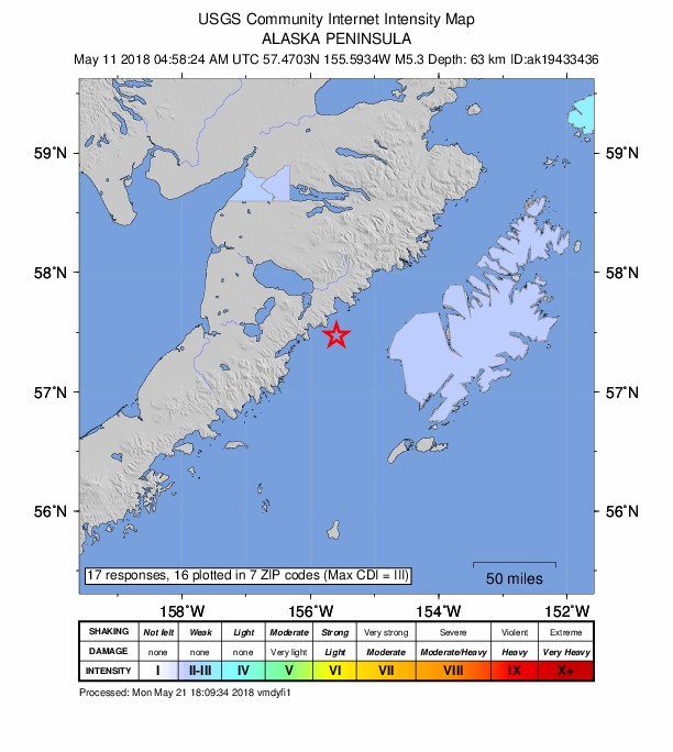
Did you feel it?
16 people reported to the USGS what they felt; the strongest reported shaking was III, weak shaking.
Fault motion and ground failure
How the rock slipped, from the moment tensor, and the USGS estimate of landslides and liquefaction.
- Faulting
- Strike-slip
- Moment magnitude
- 5.3 Mww
- Nodal plane 1
- Strike 345°, dip 73°, rake 172°
- Nodal plane 2
- Strike 78°, dip 82°, rake 17°
How well it is located
Reviewed by a seismologist.
- Stations used
- 261
Nearest places
Distance and direction from each place to the epicenter, with its forecast.
Nearby
Within 100 km, magnitude 2.3 and up: 19 in the 60 days after this one and 18 in the 30 days before it.
After
- 2.592 km ENE of Ugashik, Alaska · 3067 days ago · 11 km deep · 44 km away
- 2.849 km SSE of Ugashik, Alaska · 3063 days ago · 0 km deep · 96 km away
- 2.737 km SW of Karluk, Alaska · 3059 days ago · 48 km deep · 40 km away
- 3.053 km NE of Ugashik, Alaska · 3057 days ago · 155 km deep · 81 km away
- 2.393 km ESE of Egegik, Alaska · 3053 days ago · 9 km deep · 53 km away
- 2.493 km WNW of Karluk, Alaska · 3053 days ago · 9 km deep · 53 km away
- 2.489 km SW of Karluk, Alaska · 3049 days ago · 70 km deep · 39 km away
- 3.073 km SE of Ugashik, Alaska · 3047 days ago · 71 km deep · 82 km away
- 2.570 km E of Ugashik, Alaska · 3046 days ago · 4 km deep · 38 km away
- 3.056 km E of Ugashik, Alaska · 3044 days ago · 12 km deep · 53 km away
- 2.482 km ESE of Ugashik, Alaska · 3043 days ago · 84 km deep · 39 km away
- 2.887 km NNW of Karluk, Alaska · 3039 days ago · 3 km deep · 91 km away
- 2.5Alaska Peninsula · 3039 days ago · 1 km deep · 92 km away
- 3.451 km ENE of Ugashik, Alaska · 3028 days ago · 147 km deep · 73 km away
- 2.340 km NW of Karluk, Alaska · 3026 days ago · 65 km deep · 52 km away
- 2.374 km SE of Ugashik, Alaska · 3021 days ago · 25 km deep · 65 km away
- 3.067 km ESE of Egegik, Alaska · 3019 days ago · 148 km deep · 68 km away
- 2.330 km NW of Akhiok, Alaska · 3016 days ago · 43 km deep · 73 km away
- 4.3Alaska Peninsula · 3015 days ago · 52 km deep · 46 km away · felt by 2
Before
- 2.951 km SE of Ugashik, Alaska · 3070 days ago · 87 km deep · 76 km away
- 2.379 km ENE of Ugashik, Alaska · 3072 days ago · 11 km deep · 42 km away
- 2.497 km W of Akhiok, Alaska · 3073 days ago · 80 km deep · 59 km away
- 2.369 km NNW of Karluk, Alaska · 3073 days ago · 91 km deep · 81 km away
- 2.32 km NW of Karluk, Alaska · 3074 days ago · 46 km deep · 67 km away
- 3.0102 km SE of Ugashik, Alaska · 3082 days ago · 59 km deep · 73 km away
- 2.657 km W of Karluk, Alaska · 3082 days ago · 7 km deep · 20 km away
- 2.357 km W of Karluk, Alaska · 3082 days ago · 7 km deep · 20 km away
- 3.280 km ESE of Egegik, Alaska · 3083 days ago · 118 km deep · 58 km away
- 3.254 km W of Karluk, Alaska · 3086 days ago · 8 km deep · 21 km away
- 2.385 km NW of Karluk, Alaska · 3088 days ago · 5 km deep · 72 km away
- 2.459 km W of Karluk, Alaska · 3088 days ago · 15 km deep · 23 km away
- 2.559 km W of Karluk, Alaska · 3088 days ago · 14 km deep · 22 km away
- 2.961 km W of Karluk, Alaska · 3088 days ago · 16 km deep · 22 km away
- 3.862 km W of Karluk, Alaska · 3088 days ago · 17 km deep · 21 km away · felt by 2
- 2.361 km W of Karluk, Alaska · 3088 days ago · 10 km deep · 23 km away
- 2.512 km NW of Karluk, Alaska · 3089 days ago · 50 km deep · 60 km away
- 2.387 km E of Ugashik, Alaska · 3095 days ago · 83 km deep · 21 km away
Earthquakes todayAlaska earthquakesLive radar here
Sources
From the USGS Earthquake Hazards Program and its partner networks, event ak01860q4oj4 (also filed as ak19433436, at00p8jshb, us1000e2lp, iscgem611933380). Read Sat, Oct 3, 2026, 5:58 AM UTC.