M2.8 earthquake 23 km SE of Fox River, Alaska
A magnitude 2.8 earthquake struck 23 km SE of Fox River, Alaska on Tue, Feb 13, 2018, 4:23 PM AKST (01:23 UTC), 36 km (22 mi) below the surface.
A larger quake followed: M4.3 14 km SSW of Nanwalek, Alaska. This one was a foreshock.
Map
Where this earthquake was located, with the others nearby. Select one for its page.
The earthquake
- Magnitude
- 2.8 (ML, local (Richter)), micro
- Magnitude from
- Alaska Earthquake Center
- Local time
- UTC
- 2018-02-14 01:23:53 UTC
- Depth
- 36.2 km (22.5 mi), shallow
- Epicenter
- 59.731° N, 150.624° W
- Region
- Alaska
- Felt reports
- 3
- Tsunami flag
- No
- Status
- Reviewed by a seismologist
Magnitude estimates
Different scales measure different things and differ by a few tenths. The USGS marks one as preferred, and it is the one this page uses.
| Mag. | Scale | Computed by | Notes |
|---|---|---|---|
| 2.8 | ML, local (Richter) | Alaska Earthquake Center | Preferred · Preliminary |
| 2.8 | ML, local (Richter) | USGS National Earthquake Information Center | Reviewed |
Did you feel it?
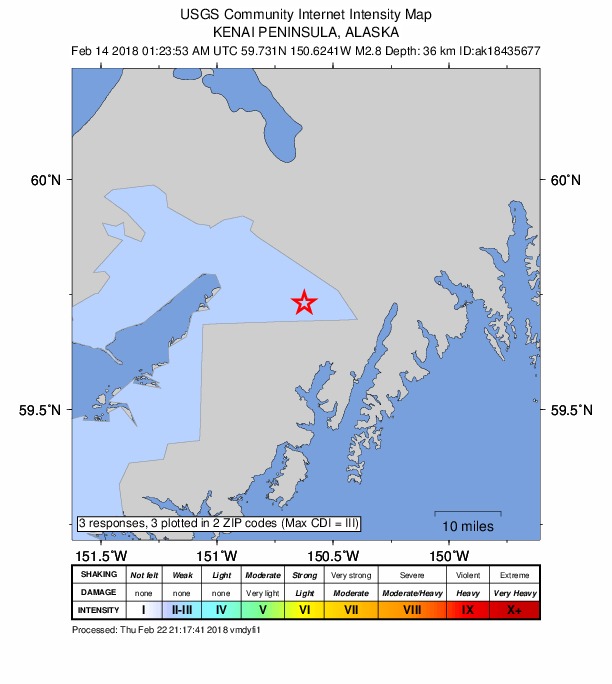
3 people reported to the USGS what they felt; the strongest reported shaking was III, weak shaking.
How well it is located
Reviewed by a seismologist.
- Stations used
- 118
Nearest places
Distance and direction from each place to the epicenter, with its forecast.
Nearby
Within 100 km, magnitude 1.5 and up: 139 in the 60 days after this one and 47 in the 30 days before it.
After
- 1.623 km NW of Ninilchik, Alaska · 3153 days ago · 82 km deep · 91 km away
- 2.529 km SW of Anchor Point, Alaska · 3153 days ago · 79 km deep · 93 km away
- 1.55 km ENE of Nikolaevsk, Alaska · 3153 days ago · 66 km deep · 51 km away
- 2.520 km W of Happy Valley, Alaska · 3152 days ago · 77 km deep · 87 km away · felt by 1
- 2.517 km ESE of Clam Gulch, Alaska · 3149 days ago · 61 km deep · 57 km away
- 1.63 km ENE of Happy Valley, Alaska · 3147 days ago · 74 km deep · 64 km away
- 2.014 km SSW of Nanwalek, Alaska · 3147 days ago · 52 km deep · 95 km away
- 2.021 km ESE of Clam Gulch, Alaska · 3146 days ago · 58 km deep · 55 km away
- 1.625 km W of Anchor Point, Alaska · 3146 days ago · 74 km deep · 93 km away
- 1.960 km SSE of Lowell Point, Alaska · 3145 days ago · 10 km deep · 82 km away
- 1.511 km WSW of Homer, Alaska · 3145 days ago · 61 km deep · 64 km away
- 1.639 km SE of Fox River, Alaska · 3144 days ago · 41 km deep · 16 km away
- 1.619 km NW of Seldovia Village, Alaska · 3143 days ago · 59 km deep · 74 km away
- 1.622 km WNW of Happy Valley, Alaska · 3142 days ago · 73 km deep · 89 km away
- 1.718 km NW of Seldovia, Alaska · 3142 days ago · 52 km deep · 77 km away
- 1.617 km WNW of Seldovia, Alaska · 3142 days ago · 55 km deep · 80 km away
- 1.527 km W of Anchor Point, Alaska · 3142 days ago · 68 km deep · 95 km away
- 2.222 km ESE of Lowell Point, Alaska · 3142 days ago · 15 km deep · 94 km away
- 1.716 km WSW of Anchor Point, Alaska · 3141 days ago · 73 km deep · 82 km away
- 2.021 km W of Happy Valley, Alaska · 3141 days ago · 73 km deep · 87 km away
- 2.718 km WNW of Nanwalek, Alaska · 3140 days ago · 64 km deep · 96 km away
- 1.66 km SSE of Kenai, Alaska · 3140 days ago · 65 km deep · 92 km away
- 2.113 km NW of Seldovia, Alaska · 3140 days ago · 55 km deep · 75 km away
- 1.932 km WNW of Happy Valley, Alaska · 3140 days ago · 70 km deep · 99 km away
- 1.931 km NNE of Fox River, Alaska · 3139 days ago · 54 km deep · 45 km away
- 1.63 km SSW of Anchor Point, Alaska · 3139 days ago · 65 km deep · 69 km away
- 2.012 km WSW of Happy Valley, Alaska · 3139 days ago · 76 km deep · 75 km away
- 2.324 km ESE of Funny River, Alaska · 3138 days ago · 39 km deep · 75 km away
- 2.016 km ESE of Clam Gulch, Alaska · 3138 days ago · 45 km deep · 58 km away
- 1.829 km SE of Halibut Cove, Alaska · 3137 days ago · 51 km deep · 43 km away
- 3.120 km SE of Kasilof, Alaska · 3137 days ago · 60 km deep · 57 km away · felt by 2
- 1.884 km SE of Port Graham, Alaska · 3137 days ago · 51 km deep · 97 km away
- 1.626 km WNW of Anchor Point, Alaska · 3136 days ago · 76 km deep · 93 km away
- 1.58 km SSE of Lowell Point, Alaska · 3134 days ago · 12 km deep · 74 km away
- 1.54 km NW of Seldovia, Alaska · 3133 days ago · 54 km deep · 71 km away
- 1.621 km S of Nanwalek, Alaska · 3133 days ago · 57 km deep · 97 km away
- 1.87 km WNW of Happy Valley, Alaska · 3133 days ago · 65 km deep · 73 km away
- 1.828 km W of Anchor Point, Alaska · 3132 days ago · 63 km deep · 96 km away
- 1.724 km NW of Anchor Point, Alaska · 3132 days ago · 75 km deep · 89 km away
- 1.56 km E of Ridgeway, Alaska · 3132 days ago · 44 km deep · 91 km away
- 1.625 km S of Port Graham, Alaska · 3132 days ago · 56 km deep · 95 km away
- 2.025 km SW of Anchor Point, Alaska · 3131 days ago · 68 km deep · 89 km away
- 2.317 km SE of Kasilof, Alaska · 3131 days ago · 58 km deep · 60 km away
- 1.8Kenai Peninsula, Alaska · 3131 days ago · 39 km deep · 56 km away
- 3.226 km S of Halibut Cove, Alaska · 3130 days ago · 43 km deep · 54 km away
- 1.67 km WSW of Anchor Point, Alaska · 3130 days ago · 63 km deep · 75 km away
- 1.67 km N of Nanwalek, Alaska · 3129 days ago · 57 km deep · 79 km away
- 2.335 km NNE of Fox River, Alaska · 3129 days ago · 56 km deep · 48 km away
- 1.526 km WNW of Happy Valley, Alaska · 3129 days ago · 74 km deep · 92 km away
- 2.518 km E of Fox River, Alaska · 3128 days ago · 37 km deep · 14 km away
- 1.712 km E of Happy Valley, Alaska · 3127 days ago · 46 km deep · 56 km away
- 3.367 km SSW of Lowell Point, Alaska · 3127 days ago · 10 km deep · 56 km away
- 1.618 km WNW of Happy Valley, Alaska · 3127 days ago · 64 km deep · 84 km away
- 1.620 km SW of Anchor Point, Alaska · 3127 days ago · 65 km deep · 81 km away
- 4.314 km SSW of Nanwalek, Alaska · 3127 days ago · 51 km deep · 95 km away · felt by 43 · tsunami flag
- 1.613 km S of Nanwalek, Alaska · 3127 days ago · 56 km deep · 93 km away
- 1.818 km SSW of Port Graham, Alaska · 3127 days ago · 69 km deep · 94 km away
- 1.814 km S of Nanwalek, Alaska · 3127 days ago · 58 km deep · 94 km away
- 1.616 km S of Nanwalek, Alaska · 3127 days ago · 55 km deep · 95 km away
- 1.514 km S of Nanwalek, Alaska · 3127 days ago · 63 km deep · 94 km away
The first 60 of 139.
Before
- 1.631 km WNW of Ninilchik, Alaska · 3154 days ago · 74 km deep · 98 km away
- 1.616 km WNW of Anchor Point, Alaska · 3158 days ago · 65 km deep · 83 km away
- 2.127 km SE of Fox River, Alaska · 3159 days ago · 35 km deep · 5 km away
- 1.620 km WSW of Anchor Point, Alaska · 3159 days ago · 67 km deep · 87 km away
- 1.620 km WNW of Happy Valley, Alaska · 3160 days ago · 81 km deep · 87 km away
- 3.518 km E of Fox River, Alaska · 3161 days ago · 32 km deep · 16 km away · felt by 23
- 1.51 km E of Homer, Alaska · 3162 days ago · 44 km deep · 51 km away
- 1.829 km WNW of Anchor Point, Alaska · 3162 days ago · 76 km deep · 97 km away
- 1.76 km NNW of Anchor Point, Alaska · 3163 days ago · 75 km deep · 71 km away
- 2.88 km NE of Ridgeway, Alaska · 3164 days ago · 75 km deep · 98 km away
- 2.219 km W of Anchor Point, Alaska · 3164 days ago · 64 km deep · 87 km away
- 1.65 km NW of Nanwalek, Alaska · 3164 days ago · 66 km deep · 86 km away
- 2.020 km ESE of Kasilof, Alaska · 3164 days ago · 65 km deep · 60 km away
- 1.83 km NNW of Nanwalek, Alaska · 3164 days ago · 51 km deep · 84 km away
- 1.617 km WNW of Anchor Point, Alaska · 3165 days ago · 72 km deep · 85 km away
- 1.621 km ESE of Kasilof, Alaska · 3167 days ago · 61 km deep · 58 km away
- 1.524 km WNW of Cooper Landing, Alaska · 3167 days ago · 39 km deep · 92 km away
- 1.52 km S of Cohoe, Alaska · 3169 days ago · 54 km deep · 79 km away
- 1.523 km E of Funny River, Alaska · 3170 days ago · 41 km deep · 87 km away
- 2.415 km ESE of Kasilof, Alaska · 3170 days ago · 58 km deep · 65 km away
Earthquakes todayAlaska earthquakesLive radar here
Sources
From the USGS Earthquake Hazards Program and its partner networks, event ak01822fx3e1 (also filed as ak18435677, us2000d1rx). Read Sun, Oct 4, 2026, 1:57 AM UTC.