M4.6 earthquake 155 km S of False Pass, Alaska
A magnitude 4.6 earthquake struck 155 km S of False Pass, Alaska on Mon, Apr 16, 2018, 6:51 AM AKDT (14:51 UTC), 10 km (6 mi) below the surface.
A larger quake followed: M5.5 160 km ESE of Akutan, Alaska. This one was a foreshock.
Map
Where this earthquake was located, with the others nearby. Select one for its page.
The earthquake
- Magnitude
- 4.6 (mb), light
- Local time
- UTC
- 2018-04-16 14:51:28 UTC
- Depth
- 10.0 km (6.2 mi), shallow
- Epicenter
- 53.454° N, 163.468° W
- Region
- Alaska
- Felt reports
- 1
- Tsunami flag
- No
- Status
- Reviewed by a seismologist
Did you feel it?
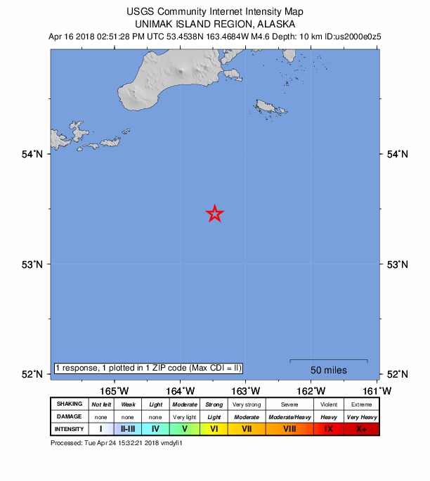
1 person reported to the USGS what they felt; the strongest reported shaking was II, weak shaking.
How well it is located
Reviewed by a seismologist.
- Location uncertainty
- About 2.7 km horizontally, 1.9 km in depth
- Magnitude uncertainty
- ±0.05
- Depth from
- Operator assigned
- Station coverage gap
- 164°
- Stations used
- 153
Nearest places
Distance and direction from each place to the epicenter, with its forecast.
Nearby
Within 100 km, magnitude 1.6 and up: 165 in the 60 days after this one and 46 in the 30 days before it.
After
- 3.5162 km S of False Pass, Alaska · 3089 days ago · 21 km deep · 7 km away
- 3.0146 km S of False Pass, Alaska · 3089 days ago · 10 km deep · 15 km away
- 2.8161 km S of False Pass, Alaska · 3089 days ago · 10 km deep · 8 km away
- 2.3102 km SSE of False Pass, Alaska · 3089 days ago · 5 km deep · 69 km away
- 2.690 km SSW of False Pass, Alaska · 3088 days ago · 48 km deep · 71 km away
- 4.6170 km S of False Pass, Alaska · 3086 days ago · 20 km deep · 15 km away
- 2.9161 km S of False Pass, Alaska · 3086 days ago · 3 km deep · 7 km away
- 2.6159 km S of False Pass, Alaska · 3086 days ago · 10 km deep · 5 km away
- 2.5158 km S of False Pass, Alaska · 3086 days ago · 10 km deep · 7 km away
- 2.6166 km S of False Pass, Alaska · 3086 days ago · 21 km deep · 11 km away
- 2.5172 km S of False Pass, Alaska · 3086 days ago · 10 km deep · 17 km away
- 2.8163 km S of False Pass, Alaska · 3086 days ago · 10 km deep · 8 km away
- 2.4165 km S of False Pass, Alaska · 3086 days ago · 26 km deep · 9 km away
- 2.4172 km S of False Pass, Alaska · 3086 days ago · 34 km deep · 17 km away
- 2.5170 km S of False Pass, Alaska · 3086 days ago · 10 km deep · 16 km away
- 3.2176 km S of False Pass, Alaska · 3086 days ago · 10 km deep · 21 km away
- 2.5163 km S of False Pass, Alaska · 3086 days ago · 7 km deep · 9 km away
- 2.4161 km S of False Pass, Alaska · 3086 days ago · 31 km deep · 8 km away
- 3.8163 km S of False Pass, Alaska · 3086 days ago · 10 km deep · 10 km away
- 2.5177 km S of False Pass, Alaska · 3086 days ago · 23 km deep · 21 km away
- 2.7165 km S of False Pass, Alaska · 3086 days ago · 10 km deep · 9 km away
- 2.5166 km S of False Pass, Alaska · 3085 days ago · 16 km deep · 12 km away
- 2.6155 km S of False Pass, Alaska · 3085 days ago · 10 km deep · 6 km away
- 2.184 km E of Akutan, Alaska · 3085 days ago · 62 km deep · 96 km away
- 2.2Unimak Island region, Alaska · 3085 days ago · 37 km deep · 36 km away
- 2.7162 km S of False Pass, Alaska · 3085 days ago · 18 km deep · 7 km away
- 1.978 km ESE of Akutan, Alaska · 3085 days ago · 44 km deep · 94 km away
- 1.892 km S of False Pass, Alaska · 3084 days ago · 20 km deep · 67 km away
- 4.3154 km ESE of Akutan, Alaska · 3084 days ago · 17 km deep · 17 km away · felt by 1
- 2.7191 km SE of Akutan, Alaska · 3084 days ago · 10 km deep · 87 km away
- 2.7193 km SE of Akutan, Alaska · 3084 days ago · 10 km deep · 93 km away
- 2.7155 km S of False Pass, Alaska · 3082 days ago · 10 km deep · 2 km away
- 3.1162 km S of False Pass, Alaska · 3082 days ago · 10 km deep · 9 km away
- 2.890 km SE of False Pass, Alaska · 3082 days ago · 25 km deep · 98 km away
- 2.7169 km S of False Pass, Alaska · 3082 days ago · 10 km deep · 13 km away
- 3.1176 km S of False Pass, Alaska · 3082 days ago · 10 km deep · 21 km away
- 2.5162 km ESE of Akutan, Alaska · 3082 days ago · 10 km deep · 14 km away
- 2.984 km SE of Akutan, Alaska · 3082 days ago · 54 km deep · 99 km away
- 2.286 km SE of Akutan, Alaska · 3082 days ago · 51 km deep · 94 km away
- 2.5147 km ESE of Akutan, Alaska · 3081 days ago · 2 km deep · 23 km away
- 3.9154 km S of False Pass, Alaska · 3081 days ago · 10 km deep · 12 km away
- 4.293 km S of False Pass, Alaska · 3081 days ago · 41 km deep · 65 km away
- 2.194 km SE of Akutan, Alaska · 3080 days ago · 26 km deep · 87 km away
- 3.491 km SSE of False Pass, Alaska · 3078 days ago · 35 km deep · 85 km away
- 2.3103 km SSW of False Pass, Alaska · 3078 days ago · 38 km deep · 74 km away
- 2.5162 km S of False Pass, Alaska · 3077 days ago · 13 km deep · 12 km away
- 2.8194 km SE of Akutan, Alaska · 3076 days ago · 20 km deep · 92 km away
- 2.3104 km S of False Pass, Alaska · 3076 days ago · 28 km deep · 51 km away
- 2.5102 km ESE of Akutan, Alaska · 3076 days ago · 27 km deep · 68 km away
- 2.4166 km S of False Pass, Alaska · 3075 days ago · 27 km deep · 10 km away
- 3.1142 km ESE of Akutan, Alaska · 3072 days ago · 26 km deep · 27 km away
- 2.8130 km SE of Akutan, Alaska · 3071 days ago · 30 km deep · 54 km away
- 3.462 km S of False Pass, Alaska · 3070 days ago · 61 km deep · 93 km away
- 3.089 km SSW of False Pass, Alaska · 3070 days ago · 35 km deep · 94 km away
- 2.5100 km S of False Pass, Alaska · 3070 days ago · 34 km deep · 61 km away
- 2.190 km SSW of False Pass, Alaska · 3070 days ago · 28 km deep · 89 km away
- 3.5108 km ESE of Akutan, Alaska · 3066 days ago · 25 km deep · 64 km away
- 3.3108 km ESE of Akutan, Alaska · 3066 days ago · 39 km deep · 67 km away
- 2.186 km SSW of False Pass, Alaska · 3066 days ago · 52 km deep · 85 km away
- 2.189 km SE of Akutan, Alaska · 3066 days ago · 54 km deep · 90 km away
The first 60 of 165.
Before
- 2.3127 km SE of Akutan, Alaska · 3090 days ago · 26 km deep · 46 km away
- 3.595 km SE of Akutan, Alaska · 3090 days ago · 15 km deep · 82 km away
- 2.597 km S of False Pass, Alaska · 3090 days ago · 22 km deep · 59 km away
- 2.999 km S of False Pass, Alaska · 3091 days ago · 25 km deep · 59 km away
- 2.3106 km S of False Pass, Alaska · 3091 days ago · 25 km deep · 52 km away
- 2.4130 km SE of Akutan, Alaska · 3091 days ago · 5 km deep · 50 km away
- 2.498 km SSE of False Pass, Alaska · 3092 days ago · 15 km deep · 81 km away
- 3.2124 km SE of Akutan, Alaska · 3092 days ago · 20 km deep · 52 km away
- 3.1123 km SE of Akutan, Alaska · 3092 days ago · 5 km deep · 53 km away
- 3.1122 km SE of Akutan, Alaska · 3092 days ago · 10 km deep · 55 km away
- 2.1104 km SSW of False Pass, Alaska · 3092 days ago · 19 km deep · 60 km away
- 2.6136 km SE of Akutan, Alaska · 3092 days ago · 10 km deep · 78 km away
- 2.1113 km SSW of False Pass, Alaska · 3093 days ago · 21 km deep · 54 km away
- 2.7146 km ESE of Akutan, Alaska · 3094 days ago · 25 km deep · 23 km away
- 2.892 km SSW of False Pass, Alaska · 3097 days ago · 31 km deep · 88 km away
- 2.2121 km ESE of Akutan, Alaska · 3098 days ago · 4 km deep · 51 km away
- 2.2100 km S of False Pass, Alaska · 3098 days ago · 17 km deep · 55 km away
- 2.8126 km SE of Akutan, Alaska · 3098 days ago · 10 km deep · 49 km away
- 2.4127 km SE of Akutan, Alaska · 3098 days ago · 27 km deep · 49 km away
- 2.4124 km SE of Akutan, Alaska · 3098 days ago · 5 km deep · 52 km away
Earthquakes todayAlaska earthquakesLive radar here
Sources
From the USGS Earthquake Hazards Program and its partner networks, event us2000e0z5 (also filed as ak19240269, ak0184vjlujo). Read Wed, Sep 30, 2026, 10:18 PM UTC.