M3.1 earthquake 28 km ENE of Buffalo, Oklahoma
A magnitude 3.1 earthquake struck 28 km ENE of Buffalo, Oklahoma on Fri, Feb 16, 2018, 9:53 AM CST (15:53 UTC), 3 km (2 mi) below the surface.
A larger quake followed: M3.8 3 km WNW of Byron, Oklahoma. This one was a foreshock.
Map
Where this earthquake was located, with the others nearby. Select one for its page.
The earthquake
- Magnitude
- 3.1 (ml), minor
- Local time
- UTC
- 2018-02-16 15:53:06 UTC
- Depth
- 2.9 km (1.8 mi), shallow
- Epicenter
- 36.955° N, 99.348° W
- Region
- Kansas
- Felt reports
- 4
- Tsunami flag
- No
- Status
- Reviewed by a seismologist
Did you feel it?
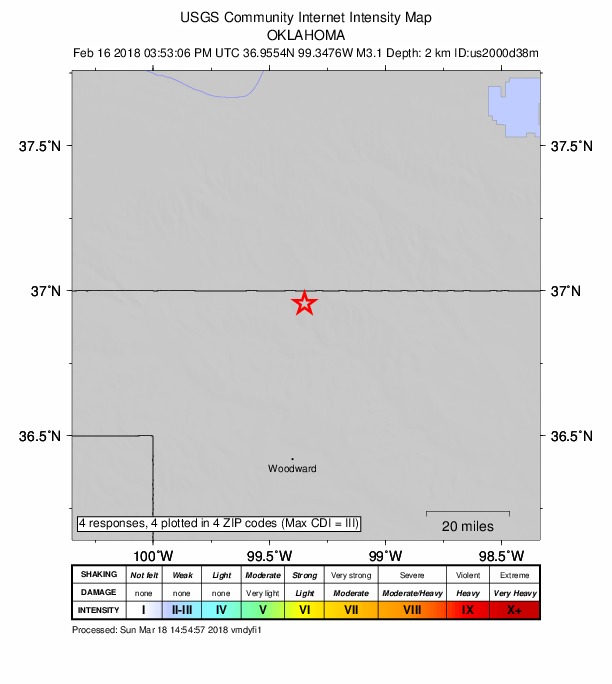
4 people reported to the USGS what they felt; the strongest reported shaking was III, weak shaking.
How well it is located
Reviewed by a seismologist.
- Location uncertainty
- About 2.3 km horizontally, 5.8 km in depth
- Station coverage gap
- 195°, poorly surrounded by stations
- Stations used
- 0
Nearest places
Distance and direction from each place to the epicenter, with its forecast.
Nearby
Within 100 km, magnitude 1.5 and up: 30 in the 60 days after this one and 20 in the 30 days before it.
After
- 2.614 km WNW of Alva, Oklahoma · 3141 days ago · 5 km deep · 48 km away
- 2.412 km NNE of Woodward, Oklahoma · 3139 days ago · 5 km deep · 46 km away · felt by 1
- 2.65 km SW of Byron, Oklahoma · 3137 days ago · 5 km deep · 90 km away
- 3.317 km SE of Waynoka, Oklahoma · 3136 days ago · 8 km deep · 76 km away · felt by 4
- 2.815 km SSE of Waynoka, Oklahoma · 3132 days ago · 5 km deep · 73 km away · felt by 2
- 2.614 km SSE of Waynoka, Oklahoma · 3131 days ago · 6 km deep · 73 km away · felt by 1
- 3.83 km WNW of Byron, Oklahoma · 3126 days ago · 8 km deep · 91 km away · felt by 124
- 3.617 km SE of Waynoka, Oklahoma · 3123 days ago · 7 km deep · 76 km away · felt by 4
- 3.08 km SE of Byron, Oklahoma · 3122 days ago · 6 km deep · 99 km away
- 2.615 km SSE of Waynoka, Oklahoma · 3119 days ago · 6 km deep · 73 km away · felt by 2
- 3.022 km NE of Fort Supply, Oklahoma · 3116 days ago · 4 km deep · 27 km away
- 2.727 km SSE of Protection, Kansas · 3116 days ago · 4 km deep · 2 km away · felt by 3
- 2.822 km NE of Fort Supply, Oklahoma · 3115 days ago · 1 km deep · 27 km away
- 2.38 km W of Buffalo, Oklahoma · 3114 days ago · 6 km deep · 36 km away
- 2.16 km WNW of Buffalo, Oklahoma · 3113 days ago · 5 km deep · 33 km away
- 3.417 km SE of Waynoka, Oklahoma · 3112 days ago · 8 km deep · 76 km away · felt by 5
- 2.79 km NE of Quinlan, Oklahoma · 3111 days ago · 6 km deep · 58 km away · felt by 1
- 2.516 km SE of Waynoka, Oklahoma · 3110 days ago · 8 km deep · 76 km away
- 2.914 km SSE of Freedom, Oklahoma · 3109 days ago · 6 km deep · 44 km away · felt by 1
- 2.614 km WNW of Waynoka, Oklahoma · 3108 days ago · 6 km deep · 44 km away
- 2.412 km WNW of Taloga, Oklahoma · 3106 days ago · 7 km deep · 98 km away · felt by 1
- 2.613 km WNW of Taloga, Oklahoma · 3106 days ago · 5 km deep · 98 km away
- 2.514 km WNW of Waynoka, Oklahoma · 3106 days ago · 6 km deep · 44 km away · felt by 1
- 2.615 km SSW of Freedom, Oklahoma · 3100 days ago · 3 km deep · 38 km away
- 2.815 km SSE of Waynoka, Oklahoma · 3099 days ago · 6 km deep · 74 km away · felt by 3
- 2.51 km SW of Cherokee, Oklahoma · 3095 days ago · 9 km deep · 90 km away
- 2.16 km WSW of Chester, Oklahoma · 3094 days ago · 7 km deep · 92 km away · felt by 1
- 2.823 km NE of Fort Supply, Oklahoma · 3092 days ago · 4 km deep · 26 km away
- 2.69 km SW of Waynoka, Oklahoma · 3088 days ago · 4 km deep · 58 km away
- 2.914 km SSE of Freedom, Oklahoma · 3088 days ago · 6 km deep · 44 km away · felt by 2
Before
- 3.79 km SW of Waynoka, Oklahoma · 3144 days ago · 7 km deep · 58 km away · felt by 13
- 2.59 km SW of Waynoka, Oklahoma · 3144 days ago · 7 km deep · 59 km away
- 2.99 km SW of Waynoka, Oklahoma · 3144 days ago · 6 km deep · 58 km away
- 2.88 km SW of Waynoka, Oklahoma · 3144 days ago · 6 km deep · 58 km away
- 3.49 km SW of Waynoka, Oklahoma · 3144 days ago · 7 km deep · 58 km away · felt by 3
- 2.78 km SW of Waynoka, Oklahoma · 3147 days ago · 5 km deep · 58 km away
- 2.727 km ENE of Buffalo, Oklahoma · 3156 days ago · 5 km deep · 1 km away
- 2.728 km ENE of Buffalo, Oklahoma · 3160 days ago · 4 km deep · 1 km away
- 2.615 km WNW of Waynoka, Oklahoma · 3161 days ago · 7 km deep · 44 km away · felt by 2
- 2.64 km NNE of Cherokee, Oklahoma · 3163 days ago · 4 km deep · 93 km away · felt by 3
- 2.8Oklahoma · 3164 days ago · 6 km deep · 58 km away · felt by 1
- 2.59 km WSW of Waynoka, Oklahoma · 3165 days ago · 6 km deep · 58 km away
- 2.77 km WSW of Waynoka, Oklahoma · 3166 days ago · 4 km deep · 58 km away
- 2.826 km NW of Freedom, Oklahoma · 3166 days ago · 0 km deep · 4 km away
- 2.525 km NE of Buffalo, Oklahoma · 3167 days ago · 8 km deep · 4 km away
- 3.014 km SSE of Waynoka, Oklahoma · 3170 days ago · 6 km deep · 73 km away
- 2.927 km ENE of Buffalo, Oklahoma · 3170 days ago · 6 km deep · 2 km away
- 2.316 km SSW of Freedom, Oklahoma · 3171 days ago · 3 km deep · 38 km away
- 2.513 km SSE of Waynoka, Oklahoma · 3172 days ago · 5 km deep · 72 km away
- 2.814 km SSE of Waynoka, Oklahoma · 3173 days ago · 6 km deep · 73 km away
Earthquakes todayKansas earthquakesLive radar here
Sources
From the USGS Earthquake Hazards Program and its partner networks, event us2000d38m. Read Sat, Sep 26, 2026, 4:51 PM UTC.