M4.2 earthquake 4 km N of Breckinridge, Oklahoma
A magnitude 4.2 earthquake struck 4 km N of Breckinridge, Oklahoma on Sun, Mar 4, 2018, 5:17 PM CST (23:17 UTC), 8 km (5 mi) below the surface.
A larger quake followed: M4.6 5 km WNW of Lucien, Oklahoma. This one was a foreshock.
Map
Where this earthquake was located, with the others nearby. Select one for its page.
The earthquake
- Magnitude
- 4.2 (Mwr, regional moment), light
- Magnitude from
- USGS National Earthquake Information Center
- Local time
- UTC
- 2018-03-04 23:17:17 UTC
- Depth
- 8.1 km (5.0 mi), shallow
- Epicenter
- 36.478° N, 97.741° W
- Region
- Oklahoma
- Felt reports
- 2,000
- Strongest shaking
- V, moderate shaking
- PAGER alert
- Green
- Tsunami flag
- No
- Status
- Reviewed by a seismologist
Deaths and damage
From NOAA NCEI’s Significant Earthquake Database (record 10580), matched to this event by time and place.
- Damage
- Moderate (about $1 to $5 million)
- Houses destroyed
- Some (about 51 to 100) with its tsunami and other effects
- Houses damaged
- Some (about 51 to 100)
Where the literature gives no number, NCEI records a description on a scale of 1 to 4, printed here in its words. Damage is in millions of US dollars of the year of the event, not adjusted for inflation.
What happened
The USGS’s account of the effects of this earthquake.
Some buildings damaged at Breckenridge and Enid.
From the USGS event page for us2000dc7w. U.S. Geological Survey text and figures are in the public domain.
Shaking
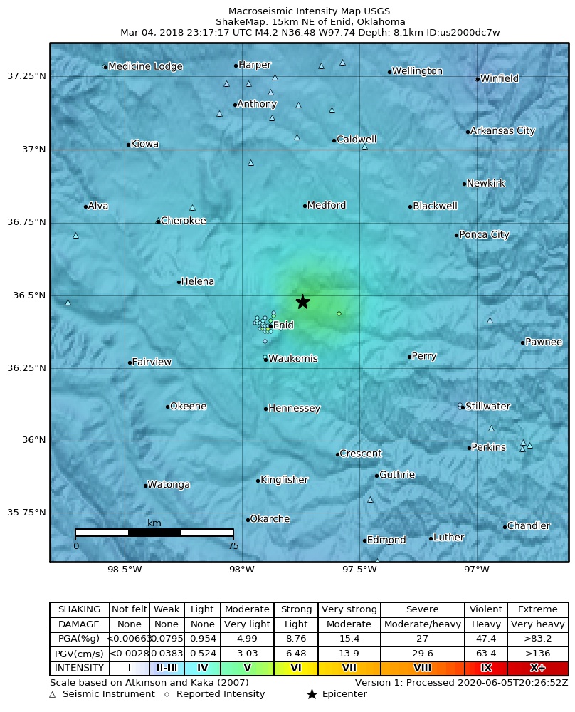
The USGS ShakeMap: shaking estimated from seismic stations and the quake’s size, on the Modified Mercalli intensity scale.
- Strongest estimated
- V, moderate shaking
- Peak ground acceleration
- 15.9% of gravity
- Peak ground velocity
- 1.4 cm/s
- Map
- Automatic
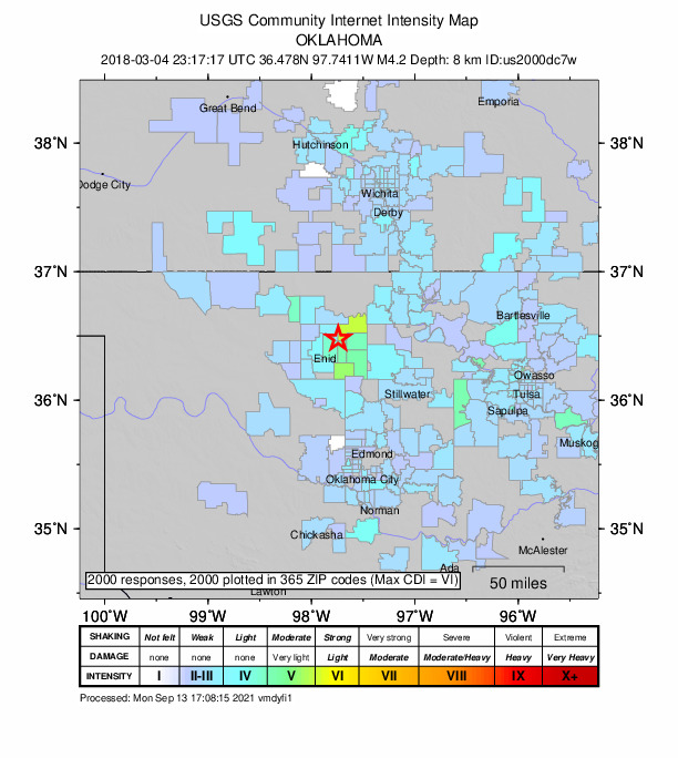
Did you feel it?
2,000 people reported to the USGS what they felt; the strongest reported shaking was VI, strong shaking.
Estimated impact
The USGS PAGER system estimates deaths and economic losses from the shaking and the population and buildings exposed to it.
- Alert level
- Green: little or no damage or loss of life expected
| Range | Chance |
|---|---|
| Under 1 | 69% |
| 1 to 10 | 29% |
| 10 to 100 | 2% |
| 100 to 1,000 | Under 1% |
| 1,000 to 10,000 | Under 1% |
| 10,000 to 100,000 | Under 1% |
| 100,000 to 10,000,000 | Under 1% |
| Range, million USD | Chance |
|---|---|
| Under 1 | 65% |
| 1 to 10 | 30% |
| 10 to 100 | 4% |
| 100 to 1,000 | Under 1% |
| 1,000 to 10,000 | Under 1% |
| 10,000 to 100,000 | Under 1% |
| 100,000 to 10,000,000 | Under 1% |
Fault motion and ground failure
How the rock slipped, from the moment tensor, and the USGS estimate of landslides and liquefaction.
- Faulting
- Strike-slip
- Moment magnitude
- 4.2 Mwr
- Nodal plane 1
- Strike 211°, dip 85°, rake -174°
- Nodal plane 2
- Strike 121°, dip 84°, rake -5°
How well it is located
Reviewed by a seismologist.
- Location uncertainty
- About 2.4 km horizontally, 8.6 km in depth
- Magnitude uncertainty
- ±0.04
- Station coverage gap
- 104°
- Stations used
- 0
Nearest places
Distance and direction from each place to the epicenter, with its forecast.
Nearby
Within 100 km, magnitude 1.5 and up: 158 in the 60 days after this one and 68 in the 30 days before it.
After
- 2.76 km WNW of Renfrow, Oklahoma · 3134 days ago · 4 km deep · 51 km away · felt by 4
- 4.25 km NNW of Breckinridge, Oklahoma · 3134 days ago · 8 km deep · 1 km away · felt by 831
- 3.05 km NNW of Breckinridge, Oklahoma · 3134 days ago · 8 km deep · 2 km away · felt by 8
- 2.84 km NNW of Breckinridge, Oklahoma · 3134 days ago · 8 km deep · 1 km away · felt by 18
- 2.18 km S of Milan, Kansas · 3133 days ago · 6 km deep · 78 km away
- 3.83 km WNW of Byron, Oklahoma · 3132 days ago · 8 km deep · 71 km away · felt by 124
- 2.53 km WNW of Lucien, Oklahoma · 3132 days ago · 6 km deep · 31 km away · felt by 2
- 2.73 km WNW of Lucien, Oklahoma · 3131 days ago · 6 km deep · 31 km away
- 1.84 km N of Anthony, Kansas · 3131 days ago · 7 km deep · 84 km away
- 3.617 km SE of Waynoka, Oklahoma · 3130 days ago · 7 km deep · 92 km away · felt by 4
- 3.16 km NNW of Breckinridge, Oklahoma · 3129 days ago · 6 km deep · 2 km away · felt by 5
- 3.08 km SE of Byron, Oklahoma · 3128 days ago · 6 km deep · 60 km away
- 2.79 km W of Lamont, Oklahoma · 3127 days ago · 8 km deep · 26 km away
- 2.615 km SSE of Waynoka, Oklahoma · 3125 days ago · 6 km deep · 97 km away · felt by 2
- 2.45 km NW of Braman, Oklahoma · 3125 days ago · 8 km deep · 63 km away
- 2.37 km E of Freeport, Kansas · 3124 days ago · 6 km deep · 80 km away
- 1.87 km E of Freeport, Kansas · 3123 days ago · 6 km deep · 80 km away
- 2.97 km E of Freeport, Kansas · 3123 days ago · 6 km deep · 80 km away
- 1.711 km W of Caldwell, Kansas · 3123 days ago · 6 km deep · 63 km away
- 1.57 km S of Argonia, Kansas · 3123 days ago · 6 km deep · 80 km away
- 2.28 km ENE of Greenfield, Oklahoma · 3122 days ago · 6 km deep · 94 km away
- 2.27 km E of Freeport, Kansas · 3122 days ago · 6 km deep · 80 km away
- 2.510 km ESE of Jefferson, Oklahoma · 3122 days ago · 8 km deep · 25 km away
- 2.49 km E of Mulhall, Oklahoma · 3120 days ago · 8 km deep · 59 km away · felt by 5
- 2.54 km N of Dover, Oklahoma · 3120 days ago · 5 km deep · 53 km away · felt by 3
- 1.913 km NNW of Caldwell, Kansas · 3120 days ago · 5 km deep · 73 km away
- 2.63 km NNW of Quay, Oklahoma · 3119 days ago · 4 km deep · 97 km away · felt by 2
- 3.417 km SE of Waynoka, Oklahoma · 3118 days ago · 8 km deep · 92 km away · felt by 5
- 3.010 km E of Dover, Oklahoma · 3117 days ago · 6 km deep · 56 km away
- 1.85 km W of Danville, Kansas · 3117 days ago · 6 km deep · 91 km away
- 2.55 km SE of Fairview, Oklahoma · 3117 days ago · 6 km deep · 68 km away · felt by 1
- 1.64 km E of Freeport, Kansas · 3117 days ago · 5 km deep · 81 km away
- 2.516 km SE of Waynoka, Oklahoma · 3116 days ago · 8 km deep · 88 km away
- 2.97 km E of Hennessey, Oklahoma · 3116 days ago · 5 km deep · 40 km away
- 1.95 km WSW of Danville, Kansas · 3116 days ago · 2 km deep · 91 km away
- 3.15 km NNW of Breckinridge, Oklahoma · 3115 days ago · 7 km deep · 2 km away · felt by 5
- 3.39 km ESE of Jefferson, Oklahoma · 3115 days ago · 8 km deep · 25 km away · felt by 3
- 2.510 km W of Lamont, Oklahoma · 3115 days ago · 8 km deep · 26 km away
- 2.28 km W of Hunnewell, Kansas · 3114 days ago · 7 km deep · 61 km away
- 3.27 km W of Hunnewell, Kansas · 3114 days ago · 7 km deep · 62 km away
- 2.09 km WSW of Hunnewell, Kansas · 3114 days ago · 6 km deep · 60 km away
- 2.75 km N of Breckinridge, Oklahoma · 3114 days ago · 5 km deep · 1 km away
- 3.05 km NE of Medford, Oklahoma · 3114 days ago · 8 km deep · 41 km away · felt by 3
- 2.28 km WSW of Hunnewell, Kansas · 3114 days ago · 5 km deep · 60 km away
- 2.46 km NNE of Wakita, Oklahoma · 3113 days ago · 4 km deep · 53 km away
- 2.55 km NNW of Breckinridge, Oklahoma · 3113 days ago · 6 km deep · 2 km away · felt by 1
- 2.65 km NNW of Breckinridge, Oklahoma · 3113 days ago · 8 km deep · 1 km away · felt by 1
- 2.67 km NNW of Lamont, Oklahoma · 3113 days ago · 7 km deep · 34 km away · felt by 1
- 2.61 km SE of Renfrow, Oklahoma · 3111 days ago · 5 km deep · 50 km away · felt by 1
- 1.67 km ESE of Freeport, Kansas · 3109 days ago · 5 km deep · 76 km away
- 2.53 km NE of Coyle, Oklahoma · 3108 days ago · 7 km deep · 74 km away · felt by 1
- 2.610 km SE of Marshall, Oklahoma · 3107 days ago · 6 km deep · 47 km away
- 2.71 km ENE of Bluff City, Kansas · 3106 days ago · 9 km deep · 68 km away
- 2.513 km WSW of Ralston, Oklahoma · 3106 days ago · 5 km deep · 78 km away
- 2.37 km E of Nescatunga, Oklahoma · 3106 days ago · 8 km deep · 43 km away
- 2.59 km N of Stillwater, Oklahoma · 3105 days ago · 3 km deep · 69 km away · felt by 19
- 2.815 km SSE of Waynoka, Oklahoma · 3105 days ago · 6 km deep · 95 km away · felt by 3
- 3.110 km SE of Marshall, Oklahoma · 3105 days ago · 6 km deep · 47 km away
- 2.213 km WSW of Ralston, Oklahoma · 3105 days ago · 5 km deep · 78 km away · felt by 1
- 2.69 km NW of Pawnee, Oklahoma · 3104 days ago · 5 km deep · 79 km away · felt by 1
The first 60 of 158.
Before
- 2.54 km N of Breckinridge, Oklahoma · 3134 days ago · 8 km deep · 0 km away
- 2.65 km N of Dover, Oklahoma · 3134 days ago · 8 km deep · 52 km away
- 2.61 km SSE of Renfrow, Oklahoma · 3135 days ago · 8 km deep · 49 km away
- 1.67 km E of Freeport, Kansas · 3135 days ago · 6 km deep · 80 km away
- 1.50 km NNW of Bluff City, Kansas · 3137 days ago · 5 km deep · 68 km away
- 2.77 km SW of Wakita, Oklahoma · 3137 days ago · 6 km deep · 45 km away · felt by 5
- 2.614 km SSE of Waynoka, Oklahoma · 3137 days ago · 6 km deep · 97 km away · felt by 1
- 1.64 km WNW of South Haven, Kansas · 3137 days ago · 5 km deep · 70 km away
- 3.73 km NE of Arcadia, Oklahoma · 3138 days ago · 5 km deep · 96 km away · felt by 41
- 2.10 km NNW of Bluff City, Kansas · 3138 days ago · 5 km deep · 68 km away
- 2.815 km SSE of Waynoka, Oklahoma · 3139 days ago · 5 km deep · 95 km away · felt by 2
- 1.96 km SE of Freeport, Kansas · 3139 days ago · 4 km deep · 77 km away
- 1.64 km WNW of South Haven, Kansas · 3139 days ago · 5 km deep · 71 km away
- 2.10 km NNW of Bluff City, Kansas · 3141 days ago · 5 km deep · 68 km away
- 3.07 km SSE of Lucien, Oklahoma · 3141 days ago · 8 km deep · 41 km away · felt by 4
- 3.05 km S of Deer Creek, Oklahoma · 3142 days ago · 8 km deep · 36 km away · felt by 2
- 3.317 km SE of Waynoka, Oklahoma · 3142 days ago · 8 km deep · 92 km away · felt by 4
- 2.67 km N of Nardin, Oklahoma · 3142 days ago · 8 km deep · 51 km away
- 2.09 km W of Medford, Oklahoma · 3142 days ago · 6 km deep · 37 km away · felt by 1
- 2.61 km SSE of Renfrow, Oklahoma · 3142 days ago · 5 km deep · 49 km away
Earthquakes todayOklahoma earthquakesLive radar here
Sources
From the USGS Earthquake Hazards Program and its partner networks, event us2000dc7w. Read Sat, Oct 3, 2026, 12:18 AM UTC.