M4.6 earthquake 48 km SW of Atka, Alaska
A magnitude 4.6 earthquake struck 48 km SW of Atka, Alaska on Wed, Mar 14, 2018, 1:42 AM HADT (10:42 UTC), 68 km (42 mi) below the surface.
Map
Where this earthquake was located, with the others nearby. Select one for its page.
The earthquake
- Magnitude
- 4.6 (mb, body-wave), light
- Magnitude from
- USGS National Earthquake Information Center
- Local time
- UTC
- 2018-03-14 10:42:27 UTC
- Depth
- 68.2 km (42.3 mi), shallow
- Epicenter
- 51.907° N, 174.732° W
- Region
- Alaska
- Felt reports
- 1
- Tsunami flag
- No
- Status
- Reviewed by a seismologist
Magnitude estimates
Different scales measure different things and differ by a few tenths. The USGS marks one as preferred, and it is the one this page uses.
| Mag. | Scale | Computed by | Notes |
|---|---|---|---|
| 4.6 | mb, body-wave | USGS National Earthquake Information Center | Preferred · Reviewed · ±0.032 · 290 stations |
| 4.6 | mb, body-wave | Alaska Earthquake Center | Preliminary |
Did you feel it?
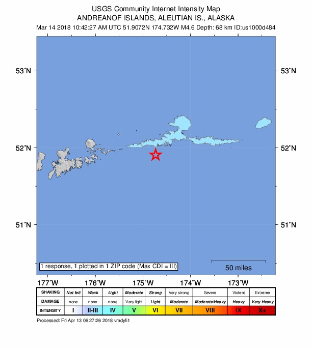
1 person reported to the USGS what they felt; the strongest reported shaking was III, weak shaking.
How well it is located
Reviewed by a seismologist.
- Location uncertainty
- About 3.0 km horizontally, 6.3 km in depth
- Magnitude uncertainty
- ±0.03
- Depth from
- From location
- Station coverage gap
- 179°
- Stations used
- 149
Nearby
Within 100 km, magnitude 1.6 and up: 53 in the 60 days after this one and 48 in the 30 days before it.
After
- 4.041 km WNW of Atka, Alaska · 3122 days ago · 222 km deep · 52 km away
- 2.785 km SE of Atka, Alaska · 3122 days ago · 18 km deep · 94 km away
- 2.444 km SSE of Atka, Alaska · 3122 days ago · 52 km deep · 55 km away
- 2.096 km ESE of Adak, Alaska · 3122 days ago · 49 km deep · 50 km away
- 2.1112 km S of Atka, Alaska · 3121 days ago · 17 km deep · 97 km away
- 1.929 km SSW of Atka, Alaska · 3121 days ago · 60 km deep · 30 km away
- 1.929 km SSW of Atka, Alaska · 3121 days ago · 59 km deep · 26 km away
- 1.878 km E of Adak, Alaska · 3121 days ago · 38 km deep · 53 km away
- 2.490 km SE of Adak, Alaska · 3121 days ago · 26 km deep · 81 km away
- 3.832 km ESE of Atka, Alaska · 3120 days ago · 82 km deep · 68 km away
- 1.661 km ESE of Adak, Alaska · 3120 days ago · 42 km deep · 80 km away
- 1.957 km SSE of Atka, Alaska · 3120 days ago · 34 km deep · 66 km away
- 2.4103 km S of Atka, Alaska · 3120 days ago · 39 km deep · 78 km away
- 2.178 km SSE of Atka, Alaska · 3119 days ago · 16 km deep · 77 km away
- 3.562 km SSW of Atka, Alaska · 3118 days ago · 55 km deep · 24 km away
- 1.763 km SSW of Atka, Alaska · 3118 days ago · 26 km deep · 21 km away
- 2.318 km SSW of Atka, Alaska · 3118 days ago · 72 km deep · 33 km away
- 1.844 km SE of Atka, Alaska · 3118 days ago · 68 km deep · 67 km away
- 2.498 km ESE of Adak, Alaska · 3114 days ago · 49 km deep · 55 km away
- 3.0Andreanof Islands, Aleutian Islands, Alaska · 3113 days ago · 23 km deep · 46 km away
- 1.757 km SE of Adak, Alaska · 3110 days ago · 49 km deep · 97 km away
- 1.653 km SSW of Atka, Alaska · 3110 days ago · 23 km deep · 26 km away
- 2.183 km ESE of Adak, Alaska · 3109 days ago · 45 km deep · 53 km away
- 2.125 km ENE of Atka, Alaska · 3109 days ago · 6 km deep · 73 km away
- 2.457 km NNW of Atka, Alaska · 3109 days ago · 211 km deep · 86 km away
- 2.649 km NE of Atka, Alaska · 3109 days ago · 207 km deep · 98 km away
- 1.752 km SE of Adak, Alaska · 3108 days ago · 62 km deep · 94 km away
- 2.263 km SE of Adak, Alaska · 3108 days ago · 53 km deep · 89 km away
- 2.715 km NW of Atka, Alaska · 3107 days ago · 147 km deep · 52 km away
- 2.557 km E of Adak, Alaska · 3107 days ago · 214 km deep · 75 km away
- 2.333 km SE of Atka, Alaska · 3107 days ago · 20 km deep · 59 km away
- 2.556 km ESE of Adak, Alaska · 3106 days ago · 52 km deep · 90 km away
- 1.717 km SW of Atka, Alaska · 3106 days ago · 7 km deep · 31 km away
- 1.847 km SE of Adak, Alaska · 3102 days ago · 49 km deep · 100 km away
- 1.646 km SSW of Atka, Alaska · 3102 days ago · 54 km deep · 29 km away
- 1.882 km SW of Atka, Alaska · 3102 days ago · 15 km deep · 36 km away
- 2.040 km ENE of Adak, Alaska · 3102 days ago · 125 km deep · 94 km away
- 2.263 km SE of Adak, Alaska · 3100 days ago · 45 km deep · 88 km away
- 2.944 km SE of Atka, Alaska · 3099 days ago · 153 km deep · 62 km away
- 2.286 km SW of Atka, Alaska · 3099 days ago · 41 km deep · 37 km away
- 2.463 km WSW of Atka, Alaska · 3099 days ago · 67 km deep · 18 km away
- 3.242 km ENE of Adak, Alaska · 3097 days ago · 155 km deep · 89 km away
- 2.347 km SSE of Atka, Alaska · 3096 days ago · 39 km deep · 49 km away
- 4.551 km NNE of Atka, Alaska · 3095 days ago · 176 km deep · 95 km away
- 3.4105 km S of Atka, Alaska · 3094 days ago · 21 km deep · 74 km away
- 2.791 km SSW of Atka, Alaska · 3094 days ago · 12 km deep · 47 km away
- 3.035 km ENE of Atka, Alaska · 3093 days ago · 152 km deep · 82 km away
- 4.094 km SW of Atka, Alaska · 3085 days ago · 58 km deep · 47 km away
- 2.047 km ESE of Adak, Alaska · 3081 days ago · 60 km deep · 90 km away
- 2.188 km WSW of Atka, Alaska · 3078 days ago · 57 km deep · 42 km away
- 2.149 km SSW of Atka, Alaska · 3076 days ago · 23 km deep · 21 km away
- 4.073 km SSE of Atka, Alaska · 3073 days ago · 41 km deep · 74 km away
- 2.862 km ESE of Adak, Alaska · 3068 days ago · 30 km deep · 79 km away
Before
- 1.865 km SW of Atka, Alaska · 3125 days ago · 54 km deep · 17 km away
- 2.3100 km S of Atka, Alaska · 3125 days ago · 38 km deep · 76 km away
- 2.885 km SE of Atka, Alaska · 3126 days ago · 41 km deep · 100 km away
- 2.557 km S of Atka, Alaska · 3126 days ago · 40 km deep · 51 km away
- 2.954 km S of Atka, Alaska · 3126 days ago · 55 km deep · 50 km away
- 2.1119 km SSW of Atka, Alaska · 3127 days ago · 26 km deep · 77 km away
- 2.2118 km S of Atka, Alaska · 3127 days ago · 12 km deep · 100 km away
- 1.862 km SSW of Atka, Alaska · 3127 days ago · 24 km deep · 24 km away
- 2.876 km SSW of Atka, Alaska · 3127 days ago · 35 km deep · 34 km away
- 2.1109 km SSW of Atka, Alaska · 3128 days ago · 5 km deep · 65 km away
- 2.670 km E of Adak, Alaska · 3130 days ago · 75 km deep · 61 km away
- 1.838 km SE of Atka, Alaska · 3133 days ago · 15 km deep · 67 km away
- 2.341 km ESE of Adak, Alaska · 3133 days ago · 51 km deep · 99 km away
- 1.865 km SW of Atka, Alaska · 3133 days ago · 22 km deep · 19 km away
- 1.863 km ESE of Adak, Alaska · 3133 days ago · 35 km deep · 82 km away
- 1.692 km SW of Atka, Alaska · 3133 days ago · 26 km deep · 44 km away
- 2.3119 km SE of Adak, Alaska · 3133 days ago · 12 km deep · 83 km away
- 2.0118 km SE of Adak, Alaska · 3133 days ago · 15 km deep · 82 km away
- 2.59 km NNE of Atka, Alaska · 3134 days ago · 145 km deep · 57 km away
- 1.770 km WSW of Atka, Alaska · 3135 days ago · 45 km deep · 24 km away
Earthquakes todayAlaska earthquakesLive radar here
Sources
From the USGS Earthquake Hazards Program and its partner networks, event us1000d484 (also filed as ak18695426, ak0183cwfq77). Read Thu, Oct 1, 2026, 10:03 PM UTC.