M3.5 earthquake 36 km WNW of Anchor Point, Alaska
A magnitude 3.5 earthquake struck 36 km WNW of Anchor Point, Alaska on Mon, Sep 3, 2018, 2:12 AM AKDT (10:12 UTC), 79 km (49 mi) below the surface.
A larger quake followed: M4.2 19 km SSW of Anchor Point, Alaska. This one was a foreshock.
Map
Where this earthquake was located, with the others nearby. Select one for its page.
The earthquake
- Magnitude
- 3.5 (ml), minor
- Local time
- UTC
- 2018-09-03 10:12:13 UTC
- Depth
- 78.5 km (48.8 mi), intermediate-depth
- Epicenter
- 59.880° N, 152.450° W
- Region
- Alaska
- Felt reports
- 1
- Tsunami flag
- No
- Status
- Reviewed by a seismologist
Did you feel it?
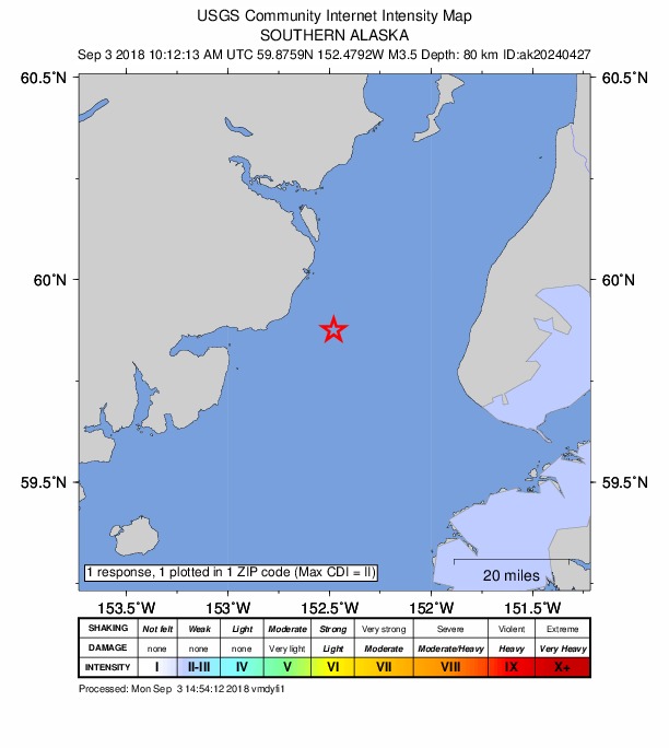
1 person reported to the USGS what they felt; the strongest reported shaking was II, weak shaking.
How well it is located
Reviewed by a seismologist.
- Stations used
- 216
Nearest places
Distance and direction from each place to the epicenter, with its forecast.
Nearby
Within 100 km, magnitude 1.5 and up: at least 201 in the 60 days after this one and 196 in the 30 days before it.
After
- 1.640 km E of Pedro Bay, Alaska · 2948 days ago · 131 km deep · 53 km away
- 1.643 km ENE of Pedro Bay, Alaska · 2948 days ago · 135 km deep · 58 km away
- 1.926 km WSW of Anchor Point, Alaska · 2948 days ago · 68 km deep · 27 km away
- 1.553 km W of Nanwalek, Alaska · 2948 days ago · 75 km deep · 53 km away
- 1.554 km W of Salamatof, Alaska · 2948 days ago · 95 km deep · 89 km away
- 1.5Southern Alaska · 2948 days ago · 74 km deep · 81 km away
- 2.352 km W of Nanwalek, Alaska · 2948 days ago · 75 km deep · 55 km away
- 1.665 km E of Port Alsworth, Alaska · 2948 days ago · 132 km deep · 51 km away
- 1.712 km NW of Anchor Point, Alaska · 2948 days ago · 78 km deep · 25 km away
- 1.525 km WNW of Salamatof, Alaska · 2948 days ago · 77 km deep · 98 km away
- 2.449 km NW of Ninilchik, Alaska · 2948 days ago · 87 km deep · 48 km away
- 3.052 km NW of Ninilchik, Alaska · 2948 days ago · 88 km deep · 51 km away
- 1.544 km E of Pedro Bay, Alaska · 2948 days ago · 118 km deep · 49 km away
- 1.722 km S of Port Graham, Alaska · 2948 days ago · 50 km deep · 89 km away
- 2.137 km WSW of Anchor Point, Alaska · 2948 days ago · 80 km deep · 21 km away
- 2.559 km ESE of Pedro Bay, Alaska · 2947 days ago · 101 km deep · 44 km away
- 1.744 km WNW of Anchor Point, Alaska · 2947 days ago · 88 km deep · 8 km away
- 2.213 km E of Happy Valley, Alaska · 2947 days ago · 47 km deep · 54 km away
- 1.655 km E of Pedro Bay, Alaska · 2947 days ago · 101 km deep · 39 km away
- 1.746 km NE of Pedro Bay, Alaska · 2946 days ago · 153 km deep · 63 km away
- 1.515 km WSW of Happy Valley, Alaska · 2946 days ago · 72 km deep · 26 km away
- 1.775 km ESE of Pope-Vannoy Landing, Alaska · 2946 days ago · 88 km deep · 90 km away
- 1.546 km ENE of Pedro Bay, Alaska · 2946 days ago · 123 km deep · 48 km away
- 2.250 km ENE of Pedro Bay, Alaska · 2945 days ago · 114 km deep · 45 km away
- 1.552 km WNW of Nanwalek, Alaska · 2945 days ago · 84 km deep · 38 km away
- 1.850 km WSW of Anchor Point, Alaska · 2945 days ago · 76 km deep · 29 km away
- 1.873 km E of Port Alsworth, Alaska · 2945 days ago · 124 km deep · 45 km away
- 1.560 km ENE of Pedro Bay, Alaska · 2945 days ago · 125 km deep · 44 km away
- 1.520 km E of Kasilof, Alaska · 2945 days ago · 59 km deep · 98 km away
- 1.962 km NE of Pedro Bay, Alaska · 2944 days ago · 123 km deep · 47 km away
- 1.917 km W of Anchor Point, Alaska · 2944 days ago · 70 km deep · 20 km away
- 2.036 km W of Salamatof, Alaska · 2944 days ago · 80 km deep · 80 km away
- 1.570 km W of Happy Valley, Alaska · 2944 days ago · 112 km deep · 35 km away
- 1.752 km E of Port Alsworth, Alaska · 2943 days ago · 148 km deep · 63 km away
- 1.956 km WNW of Ninilchik, Alaska · 2943 days ago · 105 km deep · 41 km away
- 2.658 km E of Port Alsworth, Alaska · 2943 days ago · 149 km deep · 56 km away
- 1.855 km WNW of Anchor Point, Alaska · 2943 days ago · 90 km deep · 19 km away
- 1.675 km NW of Ninilchik, Alaska · 2943 days ago · 105 km deep · 70 km away
- 2.274 km SE of Pope-Vannoy Landing, Alaska · 2943 days ago · 17 km deep · 99 km away
- 1.632 km ENE of Pedro Bay, Alaska · 2943 days ago · 154 km deep · 63 km away
- 1.762 km E of Pedro Bay, Alaska · 2943 days ago · 101 km deep · 31 km away
- 1.534 km WNW of Nanwalek, Alaska · 2943 days ago · 67 km deep · 42 km away
- 1.556 km ENE of Pedro Bay, Alaska · 2943 days ago · 126 km deep · 49 km away
- 1.557 km WNW of Nanwalek, Alaska · 2942 days ago · 96 km deep · 48 km away
- 1.538 km ESE of Pedro Bay, Alaska · 2942 days ago · 118 km deep · 63 km away
- 2.620 km ESE of Clam Gulch, Alaska · 2942 days ago · 66 km deep · 86 km away
- 3.550 km WNW of Happy Valley, Alaska · 2942 days ago · 103 km deep · 21 km away
- 1.554 km NW of Ninilchik, Alaska · 2942 days ago · 85 km deep · 51 km away
- 1.644 km ESE of Port Alsworth, Alaska · 2941 days ago · 158 km deep · 66 km away
- 2.147 km E of Pedro Bay, Alaska · 2941 days ago · 123 km deep · 46 km away
- 1.568 km WNW of Ninilchik, Alaska · 2941 days ago · 109 km deep · 54 km away
- 2.540 km NW of Ninilchik, Alaska · 2941 days ago · 91 km deep · 51 km away
- 1.748 km W of Nanwalek, Alaska · 2941 days ago · 69 km deep · 65 km away
- 1.812 km WSW of Nanwalek, Alaska · 2941 days ago · 61 km deep · 65 km away
- 1.562 km WNW of Happy Valley, Alaska · 2940 days ago · 104 km deep · 32 km away
- 1.633 km ENE of Pedro Bay, Alaska · 2940 days ago · 154 km deep · 62 km away
- 1.764 km WNW of Happy Valley, Alaska · 2940 days ago · 103 km deep · 35 km away
- 0.659 km SE of Pedro Bay, Alaska · 2940 days ago · 4 km deep · 84 km away
- 1.555 km ENE of Pedro Bay, Alaska · 2939 days ago · 120 km deep · 42 km away
- 1.550 km E of Pedro Bay, Alaska · 2939 days ago · 118 km deep · 43 km away
The first 60 of at least 201.
Before
- 2.340 km NW of Nanwalek, Alaska · 2949 days ago · 70 km deep · 35 km away
- 1.640 km E of Pedro Bay, Alaska · 2949 days ago · 143 km deep · 53 km away
- 2.859 km WNW of Happy Valley, Alaska · 2949 days ago · 107 km deep · 33 km away
- 1.518 km WSW of Salamatof, Alaska · 2949 days ago · 67 km deep · 87 km away
- 2.3Southern Alaska · 2949 days ago · 67 km deep · 20 km away
- 1.725 km WNW of Happy Valley, Alaska · 2949 days ago · 88 km deep · 27 km away
- 1.535 km W of Kalifornsky, Alaska · 2949 days ago · 74 km deep · 70 km away
- 1.952 km W of Happy Valley, Alaska · 2949 days ago · 102 km deep · 18 km away
- 2.041 km ENE of Pedro Bay, Alaska · 2949 days ago · 133 km deep · 53 km away
- 2.049 km WNW of Anchor Point, Alaska · 2949 days ago · 99 km deep · 14 km away
- 1.864 km WNW of Happy Valley, Alaska · 2950 days ago · 95 km deep · 31 km away
- 1.552 km W of Salamatof, Alaska · 2950 days ago · 111 km deep · 75 km away
- 1.757 km E of Pedro Bay, Alaska · 2950 days ago · 101 km deep · 41 km away
- 1.738 km E of Pedro Bay, Alaska · 2950 days ago · 130 km deep · 56 km away
- 1.538 km W of Kalifornsky, Alaska · 2950 days ago · 84 km deep · 71 km away
- 1.644 km E of Pedro Bay, Alaska · 2950 days ago · 125 km deep · 49 km away
- 1.5Kenai Peninsula, Alaska · 2950 days ago · 53 km deep · 99 km away
- 1.653 km W of Anchor Point, Alaska · 2950 days ago · 79 km deep · 27 km away
- 1.661 km SE of Pedro Bay, Alaska · 2951 days ago · -1 km deep · 80 km away
- 1.661 km NW of Ninilchik, Alaska · 2951 days ago · 105 km deep · 60 km away
Earthquakes todayAlaska earthquakesLive radar here
Sources
From the USGS Earthquake Hazards Program and its partner networks, event ak018bb08b6d (also filed as ak20240427, us2000h74b). Read Wed, Sep 30, 2026, 2:46 AM UTC.