M3.8 earthquake 66 km NNW of Aleneva, Alaska
A magnitude 3.8 earthquake struck 66 km NNW of Aleneva, Alaska on Tue, Oct 23, 2018, 9:42 PM AKDT (05:42 UTC), 59 km (37 mi) below the surface.
Map
Where this earthquake was located, with the others nearby. Select one for its page.
The earthquake
- Magnitude
- 3.8 (ML, local (Richter)), minor
- Magnitude from
- Alaska Earthquake Center
- Local time
- UTC
- 2018-10-24 05:42:56 UTC
- Depth
- 59.3 km (36.8 mi), shallow
- Epicenter
- 58.625° N, 153.257° W
- Region
- Alaska
- Strongest shaking
- III, weak shaking
- Tsunami flag
- No
- Status
- Reviewed by a seismologist
Magnitude estimates
Different scales measure different things and differ by a few tenths. The USGS marks one as preferred, and it is the one this page uses.
| Mag. | Scale | Computed by | Notes |
|---|---|---|---|
| 3.8 | ML, local (Richter) | Alaska Earthquake Center | Preferred · Preliminary |
| 3.8 | ML, local (Richter) | AACSE | Preliminary |
| 3.8 | ML, local (Richter) | USGS National Earthquake Information Center | Reviewed |
Shaking
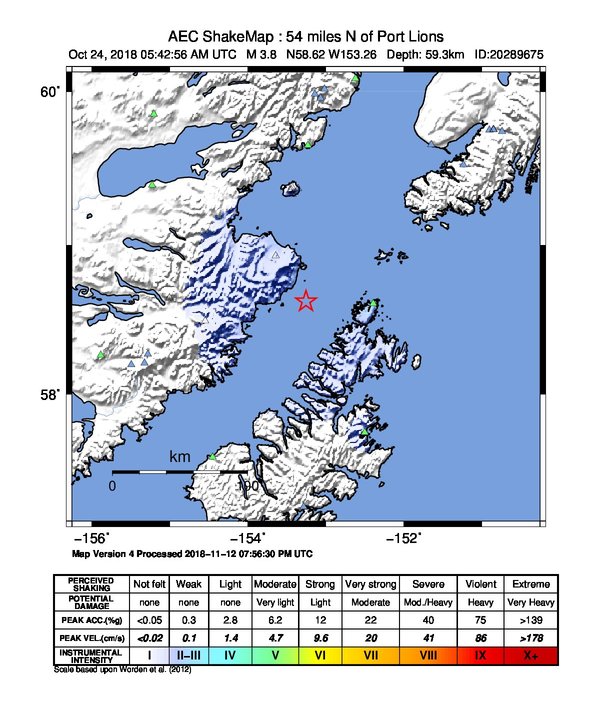
The USGS ShakeMap: shaking estimated from seismic stations and the quake’s size, on the Modified Mercalli intensity scale.
- Strongest estimated
- III, weak shaking
- Peak ground acceleration
- 212.0% of gravity
- Peak ground velocity
- 0.1 cm/s
- Map
- Automatic
Did you feel it?
No one has reported feeling this quake to the USGS.
How well it is located
Reviewed by a seismologist.
- Stations used
- 217
Nearest places
Distance and direction from each place to the epicenter, with its forecast.
Nearby
Within 100 km, magnitude 1.5 and up: 145 in the 60 days after this one and 76 in the 30 days before it.
After
- 1.976 km SW of Nanwalek, Alaska · 2899 days ago · 68 km deep · 40 km away
- 1.965 km SSE of Kokhanok, Alaska · 2899 days ago · 121 km deep · 74 km away
- 2.389 km NNW of Aleneva, Alaska · 2899 days ago · 7 km deep · 25 km away
- 1.760 km N of Aleneva, Alaska · 2898 days ago · 47 km deep · 27 km away
- 1.822 km WSW of Nanwalek, Alaska · 2898 days ago · 74 km deep · 91 km away
- 2.059 km SSE of Kokhanok, Alaska · 2898 days ago · 127 km deep · 78 km away
- 2.351 km SE of Pedro Bay, Alaska · 2896 days ago · 118 km deep · 95 km away
- 1.833 km W of Port Lions, Alaska · 2896 days ago · 52 km deep · 89 km away
- 1.7Kodiak Island region, Alaska · 2896 days ago · 70 km deep · 77 km away
- 1.781 km SSE of Kokhanok, Alaska · 2896 days ago · 94 km deep · 62 km away
- 2.144 km WSW of Nanwalek, Alaska · 2896 days ago · 61 km deep · 71 km away
- 1.671 km W of Aleneva, Alaska · 2896 days ago · 67 km deep · 69 km away
- 2.1Southern Alaska · 2895 days ago · 74 km deep · 62 km away
- 1.764 km SE of Kokhanok, Alaska · 2895 days ago · 111 km deep · 62 km away
- 1.651 km WSW of Nanwalek, Alaska · 2895 days ago · 69 km deep · 64 km away
- 1.980 km WNW of Aleneva, Alaska · 2895 days ago · 83 km deep · 56 km away
- 1.776 km WSW of Nanwalek, Alaska · 2895 days ago · 73 km deep · 48 km away
- 1.647 km W of Nanwalek, Alaska · 2894 days ago · 74 km deep · 84 km away
- 1.695 km NNW of Karluk, Alaska · 2894 days ago · 6 km deep · 93 km away
- 1.938 km SSW of Nanwalek, Alaska · 2894 days ago · 68 km deep · 74 km away
- 2.255 km SSE of Kokhanok, Alaska · 2894 days ago · 126 km deep · 84 km away
- 2.032 km WSW of Nanwalek, Alaska · 2893 days ago · 62 km deep · 83 km away
- 1.652 km WNW of Aleneva, Alaska · 2893 days ago · 64 km deep · 43 km away
- 1.725 km N of Ouzinkie, Alaska · 2892 days ago · 37 km deep · 70 km away
- 1.535 km WSW of Nanwalek, Alaska · 2892 days ago · 66 km deep · 79 km away
- 2.579 km NNE of Ouzinkie, Alaska · 2891 days ago · 31 km deep · 78 km away
- 1.597 km NNW of Karluk, Alaska · 2891 days ago · 0 km deep · 96 km away
- 1.857 km SSE of Kokhanok, Alaska · 2891 days ago · 118 km deep · 74 km away
- 1.982 km WSW of Nanwalek, Alaska · 2891 days ago · 70 km deep · 39 km away
- 2.147 km WNW of Nanwalek, Alaska · 2891 days ago · 72 km deep · 99 km away · felt by 1
- 1.954 km SSE of Pedro Bay, Alaska · 2890 days ago · 109 km deep · 85 km away
- 2.360 km SE of Kokhanok, Alaska · 2889 days ago · 106 km deep · 65 km away
- 1.956 km SW of Nanwalek, Alaska · 2889 days ago · 70 km deep · 55 km away
- 2.075 km SSW of Nanwalek, Alaska · 2888 days ago · 53 km deep · 51 km away
- 1.764 km WNW of Aleneva, Alaska · 2888 days ago · 68 km deep · 51 km away
- 1.782 km NNW of Aleneva, Alaska · 2888 days ago · 14 km deep · 25 km away
- 1.982 km N of Aleneva, Alaska · 2887 days ago · 70 km deep · 29 km away
- 2.649 km WNW of Nanwalek, Alaska · 2887 days ago · 94 km deep · 100 km away
- 1.766 km SE of Pope-Vannoy Landing, Alaska · 2887 days ago · 103 km deep · 62 km away
- 1.664 km SE of Pedro Bay, Alaska · 2886 days ago · 98 km deep · 82 km away
- 2.216 km WSW of Aleneva, Alaska · 2886 days ago · 42 km deep · 70 km away
- 1.653 km SW of Nanwalek, Alaska · 2886 days ago · 58 km deep · 59 km away
- 1.744 km WSW of Nanwalek, Alaska · 2885 days ago · 74 km deep · 77 km away
- 1.953 km SE of Pope-Vannoy Landing, Alaska · 2885 days ago · 117 km deep · 75 km away
- 1.554 km N of Karluk, Alaska · 2885 days ago · 66 km deep · 89 km away
- 2.421 km NNW of Aleneva, Alaska · 2884 days ago · 48 km deep · 45 km away
- 1.682 km NNW of Aleneva, Alaska · 2884 days ago · 11 km deep · 24 km away
- 1.844 km NE of Aleneva, Alaska · 2884 days ago · 50 km deep · 52 km away
- 1.914 km W of Aleneva, Alaska · 2884 days ago · 55 km deep · 66 km away
- 1.571 km WNW of Aleneva, Alaska · 2883 days ago · 79 km deep · 60 km away
- 1.758 km NNE of Aleneva, Alaska · 2883 days ago · 54 km deep · 35 km away
- 2.469 km SE of Kokhanok, Alaska · 2882 days ago · 5 km deep · 56 km away
- 1.546 km WNW of Nanwalek, Alaska · 2882 days ago · 86 km deep · 98 km away
- 1.543 km W of Nanwalek, Alaska · 2882 days ago · 79 km deep · 82 km away
- 1.783 km NW of Aleneva, Alaska · 2882 days ago · 84 km deep · 47 km away
- 1.743 km W of Nanwalek, Alaska · 2881 days ago · 79 km deep · 90 km away
- 2.051 km SE of Pedro Bay, Alaska · 2880 days ago · 107 km deep · 90 km away
- 2.015 km NNE of Aleneva, Alaska · 2880 days ago · 48 km deep · 53 km away
- 1.569 km SW of Nanwalek, Alaska · 2879 days ago · 53 km deep · 45 km away
- 1.567 km SE of Kokhanok, Alaska · 2878 days ago · 1 km deep · 58 km away
The first 60 of 145.
Before
- 1.766 km SE of Pope-Vannoy Landing, Alaska · 2900 days ago · 107 km deep · 65 km away
- 1.552 km W of Aleneva, Alaska · 2900 days ago · 51 km deep · 72 km away
- 1.647 km NNE of Ouzinkie, Alaska · 2901 days ago · 19 km deep · 67 km away
- 2.062 km WNW of Aleneva, Alaska · 2902 days ago · 77 km deep · 45 km away
- 2.257 km WNW of Nanwalek, Alaska · 2902 days ago · 78 km deep · 99 km away
- 1.683 km WSW of Nanwalek, Alaska · 2903 days ago · 74 km deep · 43 km away
- 1.653 km WNW of Aleneva, Alaska · 2903 days ago · 58 km deep · 44 km away
- 2.065 km SSE of Kokhanok, Alaska · 2903 days ago · 131 km deep · 78 km away
- 1.825 km SW of Nanwalek, Alaska · 2903 days ago · 64 km deep · 87 km away
- 1.961 km N of Karluk, Alaska · 2904 days ago · 58 km deep · 82 km away
- 1.665 km WNW of Aleneva, Alaska · 2904 days ago · 80 km deep · 57 km away
- 1.7Southern Alaska · 2905 days ago · 100 km deep · 69 km away
- 2.365 km NNW of Aleneva, Alaska · 2905 days ago · 64 km deep · 11 km away
- 1.661 km SE of Pedro Bay, Alaska · 2905 days ago · -1 km deep · 82 km away
- 1.785 km WNW of Aleneva, Alaska · 2905 days ago · 86 km deep · 55 km away
- 2.470 km SW of Nanwalek, Alaska · 2905 days ago · 62 km deep · 42 km away
- 2.456 km SW of Nanwalek, Alaska · 2906 days ago · 57 km deep · 55 km away
- 2.177 km SSE of Kokhanok, Alaska · 2906 days ago · 105 km deep · 69 km away
- 2.290 km NW of Aleneva, Alaska · 2906 days ago · 84 km deep · 38 km away
- 1.754 km W of Aleneva, Alaska · 2908 days ago · 55 km deep · 74 km away
Earthquakes todayAlaska earthquakesLive radar here
Sources
From the USGS Earthquake Hazards Program and its partner networks, event ak018dn9ud4s (also filed as ak20289675, us1000hgeb, aacse018dn9ud4s). Read Thu, Oct 1, 2026, 8:17 AM UTC.