M2.6 earthquake 45 km SE of Akutan, Alaska
A magnitude 2.6 earthquake struck 45 km SE of Akutan, Alaska on Sat, Feb 10, 2018, 12:24 AM AKST (09:24 UTC), 58 km (36 mi) below the surface.
A larger quake followed: M4.8 134 km SE of Akutan, Alaska. This one was a foreshock.
Map
Where this earthquake was located, with the others nearby. Select one for its page.
The earthquake
- Magnitude
- 2.6 (ML, local (Richter)), micro
- Magnitude from
- USGS National Earthquake Information Center
- Local time
- UTC
- 2018-02-10 09:24:31 UTC
- Depth
- 57.9 km (36.0 mi), shallow
- Epicenter
- 53.836° N, 165.293° W
- Region
- Alaska
- Strongest shaking
- I, not felt shaking
- PAGER alert
- Green
- Tsunami flag
- No
- Status
- Reviewed by a seismologist
Magnitude estimates
Different scales measure different things and differ by a few tenths. The USGS marks one as preferred, and it is the one this page uses.
| Mag. | Scale | Computed by | Notes |
|---|---|---|---|
| 2.6 | ML, local (Richter) | USGS National Earthquake Information Center | Preferred · Reviewed |
| 2.6 | ML, local (Richter) | Alaska Earthquake Center | Preliminary |
Shaking
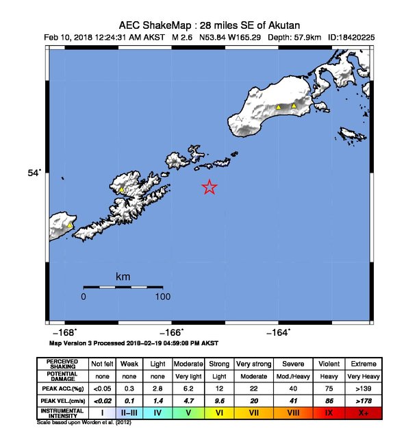
The USGS ShakeMap: shaking estimated from seismic stations and the quake’s size, on the Modified Mercalli intensity scale.
- Strongest estimated
- I, not felt shaking
- Map
- Automatic
Did you feel it?
No one has reported feeling this quake to the USGS.
Estimated impact
The USGS PAGER system estimates deaths and economic losses from the shaking and the population and buildings exposed to it.
- Alert level
- Green: little or no damage or loss of life expected
| Range | Chance |
|---|---|
| Under 1 | 69% |
| 1 to 10 | 29% |
| 10 to 100 | 2% |
| 100 to 1,000 | Under 1% |
| 1,000 to 10,000 | Under 1% |
| 10,000 to 100,000 | Under 1% |
| 100,000 to 10,000,000 | Under 1% |
| Range, million USD | Chance |
|---|---|
| Under 1 | 65% |
| 1 to 10 | 30% |
| 10 to 100 | 4% |
| 100 to 1,000 | Under 1% |
| 1,000 to 10,000 | Under 1% |
| 10,000 to 100,000 | Under 1% |
| 100,000 to 10,000,000 | Under 1% |
How well it is located
Reviewed by a seismologist.
- Location uncertainty
- About 5.8 km horizontally, 8.2 km in depth
- Stations used
- 31
Nearest places
Distance and direction from each place to the epicenter, with its forecast.
Nearby
Within 100 km, magnitude 1.5 and up: 89 in the 60 days after this one and 38 in the 30 days before it.
After
- 2.368 km SE of Unalaska, Alaska · 3155 days ago · 37 km deep · 65 km away
- 3.372 km SE of Unalaska, Alaska · 3153 days ago · 32 km deep · 65 km away
- 1.770 km SE of Unalaska, Alaska · 3153 days ago · 49 km deep · 49 km away
- 2.271 km SE of Unalaska, Alaska · 3153 days ago · 29 km deep · 63 km away
- 2.192 km SE of Unalaska, Alaska · 3153 days ago · 23 km deep · 70 km away
- 2.4115 km ESE of Akutan, Alaska · 3153 days ago · 54 km deep · 78 km away
- 2.2110 km ESE of Akutan, Alaska · 3152 days ago · 41 km deep · 67 km away
- 2.591 km SSW of False Pass, Alaska · 3151 days ago · 30 km deep · 88 km away
- 2.187 km SE of Unalaska, Alaska · 3149 days ago · 23 km deep · 73 km away
- 2.137 km S of Akutan, Alaska · 3148 days ago · 47 km deep · 28 km away
- 4.696 km SE of Akutan, Alaska · 3145 days ago · 34 km deep · 50 km away
- 2.095 km SE of Akutan, Alaska · 3145 days ago · 43 km deep · 50 km away
- 2.5131 km ESE of Akutan, Alaska · 3145 days ago · 2 km deep · 89 km away
- 2.897 km SE of Akutan, Alaska · 3145 days ago · 22 km deep · 52 km away
- 1.86 km ESE of Unalaska, Alaska · 3144 days ago · 11 km deep · 75 km away
- 2.539 km S of Akutan, Alaska · 3142 days ago · 37 km deep · 40 km away
- 2.7113 km SSW of False Pass, Alaska · 3142 days ago · 22 km deep · 86 km away
- 2.086 km ENE of Akutan, Alaska · 3142 days ago · 3 km deep · 89 km away
- 1.885 km ENE of Akutan, Alaska · 3142 days ago · -1 km deep · 88 km away
- 2.169 km SE of Akutan, Alaska · 3140 days ago · 38 km deep · 24 km away
- 2.045 km SSE of Unalaska, Alaska · 3139 days ago · 60 km deep · 81 km away
- 4.8134 km SE of Akutan, Alaska · 3138 days ago · 9 km deep · 89 km away
- 3.4135 km SE of Akutan, Alaska · 3138 days ago · 15 km deep · 90 km away
- 1.73 km E of Unalaska, Alaska · 3134 days ago · 10 km deep · 78 km away
- 1.777 km SE of Unalaska, Alaska · 3134 days ago · 12 km deep · 51 km away
- 1.979 km SSE of Akutan, Alaska · 3133 days ago · 1 km deep · 35 km away
- 2.0100 km SE of Akutan, Alaska · 3132 days ago · 58 km deep · 56 km away
- 1.776 km SSE of Unalaska, Alaska · 3132 days ago · 36 km deep · 80 km away
- 3.442 km ESE of Unalaska, Alaska · 3132 days ago · 67 km deep · 49 km away
- 1.883 km SSE of Akutan, Alaska · 3131 days ago · 50 km deep · 40 km away
- 3.433 km E of Akutan, Alaska · 3131 days ago · 85 km deep · 29 km away
- 2.256 km SSE of Akutan, Alaska · 3130 days ago · 65 km deep · 13 km away
- 1.67 km NW of Dutch Harbor, Alaska · 3129 days ago · 14 km deep · 87 km away
- 2.039 km SSE of Unalaska, Alaska · 3126 days ago · 91 km deep · 75 km away
- 3.6144 km SE of Akutan, Alaska · 3126 days ago · 10 km deep · 99 km away
- 2.072 km ESE of Akutan, Alaska · 3126 days ago · 65 km deep · 44 km away
- 2.376 km SE of Akutan, Alaska · 3125 days ago · 48 km deep · 31 km away
- 1.651 km SSE of Akutan, Alaska · 3123 days ago · 33 km deep · 20 km away
- 2.067 km ESE of Akutan, Alaska · 3123 days ago · 60 km deep · 29 km away
- 1.919 km SE of Akutan, Alaska · 3123 days ago · 106 km deep · 26 km away
- 1.927 km SSW of Unalaska, Alaska · 3121 days ago · 82 km deep · 98 km away
- 1.829 km SSW of Unalaska, Alaska · 3120 days ago · 77 km deep · 99 km away
- 3.126 km SE of Unalaska, Alaska · 3119 days ago · 16 km deep · 63 km away
- 3.425 km SE of Unalaska, Alaska · 3119 days ago · 12 km deep · 65 km away
- 1.6Fox Islands, Aleutian Islands, Alaska · 3119 days ago · 7 km deep · 65 km away
- 3.553 km SE of Unalaska, Alaska · 3118 days ago · 66 km deep · 53 km away
- 2.4111 km ESE of Akutan, Alaska · 3117 days ago · 31 km deep · 70 km away
- 2.1119 km SSW of False Pass, Alaska · 3117 days ago · 26 km deep · 88 km away
- 2.973 km SW of False Pass, Alaska · 3116 days ago · 75 km deep · 95 km away
- 2.093 km SSW of False Pass, Alaska · 3116 days ago · 26 km deep · 79 km away
- 2.094 km SE of Akutan, Alaska · 3116 days ago · 52 km deep · 49 km away
- 1.951 km SE of Akutan, Alaska · 3115 days ago · 44 km deep · 8 km away
- 1.943 km ESE of Unalaska, Alaska · 3114 days ago · 34 km deep · 48 km away
- 1.775 km SSE of Akutan, Alaska · 3113 days ago · 19 km deep · 37 km away
- 2.041 km SE of Akutan, Alaska · 3111 days ago · 64 km deep · 6 km away
- 1.79 km WSW of Akutan, Alaska · 3111 days ago · 8 km deep · 51 km away
- 2.8140 km SE of Akutan, Alaska · 3110 days ago · 24 km deep · 94 km away
- 2.888 km E of Akutan, Alaska · 3110 days ago · 10 km deep · 73 km away
- 2.550 km ESE of Akutan, Alaska · 3110 days ago · 71 km deep · 27 km away
- 1.856 km SSE of Unalaska, Alaska · 3109 days ago · 44 km deep · 69 km away
The first 60 of 89.
Before
- 2.960 km ESE of Akutan, Alaska · 3155 days ago · 72 km deep · 32 km away
- 3.681 km SE of Unalaska, Alaska · 3156 days ago · 35 km deep · 69 km away
- 2.774 km S of Akutan, Alaska · 3156 days ago · 52 km deep · 44 km away
- 2.057 km SSE of Unalaska, Alaska · 3157 days ago · 40 km deep · 73 km away
- 2.06 km NNW of Dutch Harbor, Alaska · 3161 days ago · 5 km deep · 85 km away
- 1.77 km NNW of Dutch Harbor, Alaska · 3161 days ago · 8 km deep · 85 km away
- 2.7140 km SSE of Akutan, Alaska · 3161 days ago · 10 km deep · 95 km away
- 2.716 km SSW of Akutan, Alaska · 3161 days ago · 115 km deep · 40 km away
- 2.177 km ESE of Akutan, Alaska · 3162 days ago · 37 km deep · 46 km away
- 2.494 km SSW of False Pass, Alaska · 3166 days ago · 21 km deep · 81 km away
- 2.173 km SSE of Akutan, Alaska · 3167 days ago · 23 km deep · 38 km away
- 2.131 km W of Akutan, Alaska · 3167 days ago · 110 km deep · 73 km away
- 2.143 km S of Unalaska, Alaska · 3168 days ago · 64 km deep · 94 km away
- 2.1109 km SE of Unalaska, Alaska · 3171 days ago · 19 km deep · 86 km away
- 1.954 km SSE of Unalaska, Alaska · 3175 days ago · 44 km deep · 78 km away
- 2.183 km E of Akutan, Alaska · 3176 days ago · 33 km deep · 55 km away
- 2.225 km ESE of Unalaska, Alaska · 3176 days ago · 74 km deep · 57 km away
- 1.823 km ESE of Akutan, Alaska · 3176 days ago · 70 km deep · 26 km away
- 3.672 km ESE of Akutan, Alaska · 3177 days ago · 59 km deep · 33 km away
- 2.190 km SE of Akutan, Alaska · 3177 days ago · 23 km deep · 45 km away
Earthquakes todayAlaska earthquakesLive radar here
Sources
From the USGS Earthquake Hazards Program and its partner networks, event us2000d09r (also filed as ak0181vyjca7, ak18420225). Read Thu, Oct 1, 2026, 3:26 AM UTC.